- Pennsylvania Route 412
-
PA Route 412 Route information Maintained by PennDOT Length: 17.75 mi[1] (29 km) Existed: 1928 – present Major junctions South end:  PA 611 in Nockamixon Township.
 I-78 in Hellertown
North end:  PA 378 in Bethlehem
Location Counties: Bucks, Northampton Highway system Roads in Pennsylvania
Interstate • US • State • Legislative←  PA 410
PA 413  →
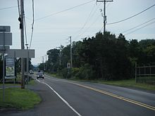
→Pennsylvania Route 412 is a 17.75-mile (28.57 km) long north–south state route located in Northampton and Bucks counties in southeastern Pennsylvania. Its southern terminus is at Pennsylvania Route 611 in the Nockamixon Township community of Harrow. Its northern terminus is at Pennsylvania Route 378 (Wyandotte Street) in Bethlehem.
In the Springtown, Springfield Township area, PA 412 runs concurrent with PA Route 212 for about two miles (3 km). The two routes split south of Springtown. By following PA 212 west, travelers can reach Quakertown, where the route intersects with PA Route 313. Alternatively, PA 212 east leads to Riegelsville, where it intersects with PA Route 611.
Contents
Route description
Route 412 begins at an intersection with PA Route 611 in the hamlet of Harrow, a part of Nockamixon Township. The route traverses Nockamixon Township as Durham Road with a northwest and southeast alignment. About 2,795 feet[1] north to the southern terminus, Route 412 intersects PA Route 563. After crossing PA 563, Route 412 continues northward, passing the rural land of Bucks County. In the township of Springfield, Route 412 runs concurrent with PA Route 212 for 1.9 miles (3.1 km). The direction of the concurrency is east and west. At milepost 8.84, Route 412 splits from PA 212 and travels to the north.
Route 412 enters Northampton County from the south as Leithsville Road. Upon entering the borough of Hellertown, Route 412 is named Main Street, the principal north and south street of Hellertown. Route 412 interchanges exit 67 of Interstate 78, at the boundary of Hellertown and the city of Bethlehem. Outside of Hellertown, Route 412 is called Hellertown Road, passing the southeastern sections of Historic Bethlehem. Route 412 crosses the Saucon Creek at the junction with Shimersville Road, while turning to the west. This section is now East 4th Street.
The route runs directly through what is still left of this former steel manufacturer — Bethlehem Steel. The route turns to the northwest and is named Daly Avenue, then intersects Stefko Boulevard; a crossing of the Lehigh River via the Minsi Trail Bridge. West of Stefko Blvd., Route 412 intersects and becomes East Third Street. After becoming 3rd Street, the route intersects New Street; another crossing of the Lehigh River via the Fahy Bridge. Briefly west of New Street, Route 412 turns southward to become Broadhead Avenue and turns again to the southwest to become Broadway. Upon becoming Broadway, the route terminates at an intersection with PA Route 378 at an intersection known locally as Five Points.
History
Signed in 1928 as a spur route of PA 12, which ran on the current PA 378 alignment.[2]
Major intersections
County Location Mile[1] Destinations Notes Bucks Nockamixon Township 0.00  PA 611
0.53  PA 563
Northern terminus of PA 563 Springfield Township 6.94  PA 212
Eastern terminus of PA 212 concurrency 8.84  PA 212
Western terminus of PA 212 concurrency Northampton Hellertown 14.19  I-78
I-78Exit 67 on I-78 Bethlehem 17.75  PA 378
1.000 mi = 1.609 km; 1.000 km = 0.621 mi References
- ^ a b c Calculated using DeLorme Street Atlas USA 2007
- ^ Pennsylvania Department of Highways (1929). Bethlehem Highway Map (Map). http://www.broermapsonline.org/members/NorthAmerica/UnitedStates/Midatlantic/Pennsylvania/bluebook1929_003.html. Retrieved 2007-12-28.
External links
 Media related to Pennsylvania Route 412 at Wikimedia Commons
Road transportation infrastructure of the metro Philadelphia area Interstates U.S. Routes Pennsylvania Routes New Jersey Routes Delaware Routes Named roads/streets Benjamin Franklin Parkway · Broad Street · City Avenue · Front Street · Girard Avenue · Market Street · Roosevelt Boulevard · South Street · Chestnut Street · Walnut Street
Pennsylvania Turnpike · New Jersey Turnpike · Delaware Turnpike · Atlantic City Expressway · Schuylkill Expressway · Delaware Expressway · Blue Route · Vine St Expressway · North South Freeway · Lancaster Avenue · Bethlehem Pike · Baltimore Pike · Black Horse PikeBridges Delaware Memorial Bridge · Commodore Barry Bridge · Walt Whitman Bridge · Ben Franklin Bridge · Betsy Ross Bridge · Tacony–Palmyra Bridge · Burlington–Bristol Bridge · Delaware River – Turnpike Toll BridgeTransportation infrastructure of the Lehigh Valley Interstates U.S. Routes Pennsylvania Routes New Jersey Routes County Routes Named roads/streets Bridges Albertus L. Meyers Bridge · Hill to Hill Bridge · Philip J. Fahy Memorial Bridge · Minsi Trail Bridge · Easton–Phillipsburg Toll Bridge · Northampton Street Bridge · Interstate 78 Toll Bridge
Tunnels Public transportation Lehigh and Northampton Transportation Authority (Bethlehem Loop) · Trans-Bridge Lines · NJ Transit
Airports Waterways Rail Categories:- State highways in Pennsylvania
Wikimedia Foundation. 2010.


