- Bradford County, Pennsylvania
-
Bradford County, Pennsylvania 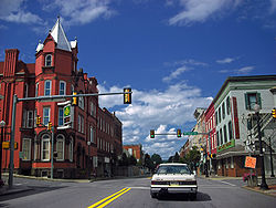 Towanda is the county seat
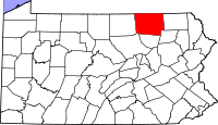
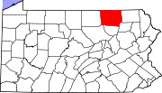
Location in the state of Pennsylvania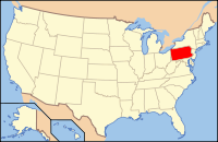
Pennsylvania's location in the U.S.Founded February 21, 1810 Seat Towanda Largest city borough of Sayre Area
- Total
- Land
- Water
1,161 sq mi (3,007 km²)
1,151 sq mi (2,981 km²)
10 sq mi (26 km²), 0.89%Population
- (2010)
- Density
62,622
54/sq mi (21/km²)Website www.bradfordcountypa.org Bradford County is a county located in the U.S. state of Pennsylvania. As of 2010, the population was 62,622. The county was created on February 21, 1810, from parts of Lycoming and Luzerne Counties. Originally called Ontario County, it was reorganized and separated from Lycoming County on October 13, 1812, and renamed Bradford County for William Bradford, who had been a chief justice of the Pennsylvania Supreme Court and United States Attorney General.[1][2] Its county seat is Towanda[3]. The county is not to be confused with the city of Bradford, which is in McKean County, 141 miles to the west via U.S. Route 6.
Contents
Law and government
County commissioners
- Doug McLinko, Chairman, Republican
- Daryl Miller, Republican
- Mark W. Smith, Democrat
Other county officials
- Clerk of Courts and Prothonotary, Sally Vaughn, Republican
- Coroner, Thomas Carman, Republican
- District Attorney, Daniel Barrett, Republican
- Register of Wills and Recorder of Deeds, Shirley Rockefeller, Republican
- Sheriff, Steven Evans, Republican
- Treasurer, Becky Clark, Republican
- Jury Commissioners, Bill Dell, Republican and Edward Barrett, Democrat
Pennsylvania State Senate
- Gene Yaw, Republican, Pennsylvania's 23rd Senatorial District
Pennsylvania House of Representatives
- Matthew E. Baker, Republican, Pennsylvania's 68th Representative District
- Tina Pickett, Republican, Pennsylvania's 110th Representative District
United States House of Representatives
- Tom Marino, Republican, Pennsylvania's 10th congressional district
United States Senate
Geography
According to the U.S. Census Bureau, the county has a total area of 1,161 square miles (3,007.0 km2), of which 1,151 square miles (2,981.1 km2) is land and 10 square miles (25.9 km2) (0.89%) is water.
Adjacent Counties
- Chemung County, New York (north)
- Tioga County, New York (north)
- Susquehanna County (east)
- Wyoming County (southeast)
- Sullivan County (south)
- Lycoming County (southwest)
- Tioga County (west)

Chemung County, New York and Tioga County, New York Tioga County 
Susquehanna County  Bradford County, Pennsylvania

Lycoming County Sullivan County Wyoming County Demographics
Historical populations Census Pop. %± 1820 11,554 — 1830 19,746 70.9% 1840 32,769 66.0% 1850 42,831 30.7% 1860 48,734 13.8% 1870 53,204 9.2% 1880 58,541 10.0% 1890 59,233 1.2% 1900 59,403 0.3% 1910 54,526 −8.2% 1920 53,166 −2.5% 1930 49,039 −7.8% 1940 50,615 3.2% 1950 51,722 2.2% 1960 54,925 6.2% 1970 57,962 5.5% 1980 62,919 8.6% 1990 60,967 −3.1% 2000 62,761 2.9% 2010 62,622 −0.2% [4][5] As of the census[6] of 2000, there were 62,761 people, 24,453 households, and 17,312 families residing in the county. The population density was 54 people per square mile (21/km²). There were 28,664 housing units at an average density of 25 per square mile (10/km²). The racial makeup of the county was 97.94% White, 0.40% Black or African American, 0.31% Native American, 0.45% Asian, 0.01% Pacific Islander, 0.19% from other races, and 0.69% from two or more races. 0.63% of the population were Hispanic or Latino of any race. 19.0% were of German, 16.3% English, 16.1% American, 12.6% Irish and 6.4% Italian ancestry according to Census 2000.
There were 24,453 households out of which 31.80% had children under the age of 18 living with them, 57.40% were married couples living together, 8.90% had a female householder with no husband present, and 29.20% were non-families. 24.70% of all households were made up of individuals and 11.50% had someone living alone who was 65 years of age or older. The average household size was 2.52 and the average family size was 2.99.
In the county, the population was spread out with 25.50% under the age of 18, 6.80% from 18 to 24, 27.20% from 25 to 44, 24.70% from 45 to 64, and 15.70% who were 65 years of age or older. The median age was 39 years. For every 100 females there were 95.10 males. For every 100 females age 18 and over, there were 92.10 males.
Economy
Major employers are the natural gas industry, DuPont, Global-Tungsten and Powders (former Sylvania), Masonite, and Cargill Regional Beef, Wyalusing.
Municipalities
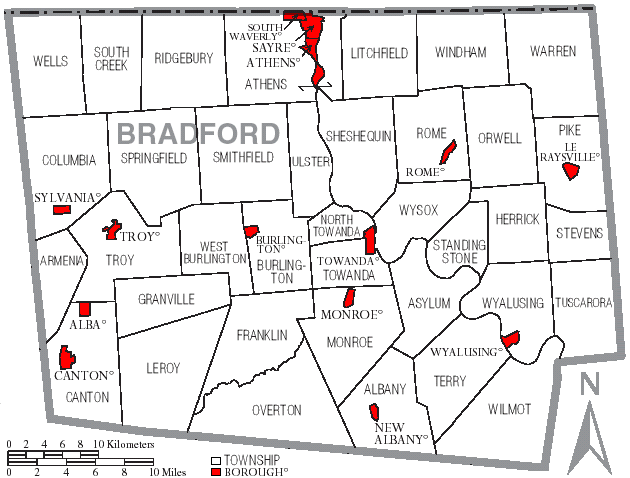
 Map of Bradford County, Pennsylvania with Municipal Labels showing Boroughs (red) and Townships (white).
Under Pennsylvania law, there are four types of incorporated municipalities: cities, boroughs, townships, and, in only one case (Bloomsburg, Columbia County), towns. The following boroughs and townships are located in Bradford County:
Boroughs
Townships
Unincorporated Communities
- Berrytown
- Browntown
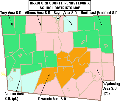
 Map of Bradford County, Pennsylvania School Districts
Education
Public School Districts
- Athens Area School District
- Canton Area School District (also in Lycoming and Tioga Counties)
- Northeast Bradford School District
- Sayre Area School District
- Towanda Area School District
- Troy Area School District
- Wyalusing Area School District (also in Wyoming County)
- There are 11 public cyber charter schools in Pennsylvania that are available for free statewide, to children K-12. See: Education in Pennsylvania.
Non-Public Schools
North Rome Christian School
Epiphany School (Catholic) K-8Transportation
Public transportation is provided by Endless Mountains Transportation Authority.
Recreation
There is one Pennsylvania state park in Bradford County.
See also
- List of municipal authorities in Bradford County, Pennsylvania
- National Register of Historic Places listings in Bradford County, Pennsylvania
References
- ^ An outline history of Tioga and Bradford counties in Pennsylvania, Chemung, Steuben, Tioga, Tompkins and Schuyler in New York: by townships, villages, boro's and cities, John L. Sexton. The Gazette Company, 1885, p67. http://books.google.com/books?id=kWlCAAAAYAAJ&pg=PA67&dq=bradford+county,+pa.+sexton#v=onepage&q&f=false. Retrieved 2010-09-17.
- ^ Bradford County History, Bradford County, Pennsylvania. Accessed August 21, 2007
- ^ "Find a County". National Association of Counties. http://www.naco.org/Counties/Pages/FindACounty.aspx. Retrieved 2011-06-07.
- ^ http://factfinder2.census.gov
- ^ http://mapserver.lib.virginia.edu/
- ^ "American FactFinder". United States Census Bureau. http://factfinder.census.gov. Retrieved 2008-01-31.
External links
- Official Bradford County Government Website
- Bradford County Historical Society
- Bradford County Tourist and Visitor Guide
- Pennsylvania Department of Transportation, Bureau of Planning and Research, Geographic Information Division, "2005 General Highway Map of Bradford County". Note: shows boroughs, townships, roads, villages, some streams. URL accessed on April 6, 2006.
Municipalities and communities of Bradford County, Pennsylvania Boroughs Alba | Athens | Burlington | Canton | Le Raysville | Monroe | New Albany | Rome | Sayre | South Waverly | Sylvania | Towanda | Troy | Wyalusing
Townships Albany | Armenia | Asylum | Athens | Burlington | Canton | Columbia | Franklin | Granville | Herrick | Leroy | Litchfield | Monroe | North Towanda | Orwell | Overton | Pike | Ridgebury | Rome | Sheshequin | Smithfield | South Creek | Springfield | Standing Stone | Stevens | Terry | Towanda | Troy | Tuscarora | Ulster | Warren | Wells | West Burlington | Wilmot | Windham | Wyalusing | Wysox
Unincorporated
communitiesBerrytown | Browntown
Categories:- Pennsylvania counties
- Bradford County, Pennsylvania
- 1810 establishments in the United States
- Populated places established in 1810


Wikimedia Foundation. 2010.