- Clearfield County, Pennsylvania
-
Clearfield County, Pennsylvania 
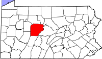
Location in the state of Pennsylvania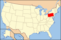
Pennsylvania's location in the U.S.Founded March 26, 1804 Seat Clearfield Largest city DuBois Area
- Total
- Land
- Water
1,154 sq mi (2,989 km²)
1,147 sq mi (2,971 km²)
, 0.56%Population
- (2010)
- Density
81,642
71/sq mi (27.4/km²)Website www.clearfieldco.org Clearfield County is a county located in the U.S. state of Pennsylvania. As of 2010, the population was 81,642.
Clearfield County was created on March 26, 1804, from parts of Huntingdon and Lycoming Counties but was administered as part of Centre County until 1812. Its county seat is Clearfield[1].
Contents
Law and Government
As of November 2008, there are 51,471 registered voters in Clearfield County.[2]
- Democratic: 23,462 (45.58%)
- Republican: 23,055 (44.79%)
- Other parties: 4,954 (9.62%)
While the county registration tends to be evenly matched between Democrats and Republicans, the county trends Republican in statewide elections. In 2006, Democrat Bob Casey Jr. received 55% of its vote when he unseated incumbent Republican US Senator Rick Santorum and Ed Rendell received 50.2% of the vote against Lynn Swann. Each of the three row-office statewide winners carried Clearfield in 2008.
County commissioners
- John Sobel, Republican
- Joan McMillen, Republican
- Mark McCracken, Democrat
Other county offices
- Clerk of Courts and Prothonotary, William A. Shaw, Democrat
- Controller, Antonio Scotto, Republican
- District Attorney, William A. Shaw Jr., Democrat
- Register of Wills and Recorder of Deeds, Maurene Inlow, Republican
- Sheriff, Chester Hawkins, Republican
- Treasurer, Carol Fox, Democrat
Pennsylvania State Senate
District Senator Party 25 Joseph B. Scarnati Republican 35 John N. Wozniak Democrat 41 Donald C. White Republican Pennsylvania House of Representatives
District Representative Party 74 Camille "Bud" George Democrat 75 Matt Gabler Republican United States House of Representatives
District Representative Party 5 Glenn "G.T." Thompson Republican 9 Bill Shuster Republican United States Senate
Senator Party Pat Toomey Republican Bob Casey Democrat Geography
According to the U.S. Census Bureau, the county has a total area of 2,988 square kilometers (1,154 sq mi). 2,972 km2 (1,147 sq mi) of it is land and 17 km2 (7 sq mi) of it (0.56%) is water.
The mountainous terrain of the county made traffic difficult for early settlers. Various Native American paths and trails crossing the area were used intermittently by settlers, invading armies, and escaped slaves travelling north along the Underground Railroad. A major feature located in Bloom Township, Pennsylvania within the county is known as Bilger's rocks and exhibits fine examples of exposed sandstone bedrock that was created during the formation of the Appalachian Mountains.
Adjacent counties
- Elk County (north)
- Cameron County (north)
- Clinton County (northeast)
- Centre County (east)
- Blair County (southeast)
- Cambria County (south)
- Indiana County (west)
- Jefferson County (west)
Demographics
Historical populations Census Pop. %± 1810 875 — 1820 2,342 167.7% 1830 4,803 105.1% 1840 7,834 63.1% 1850 12,586 60.7% 1860 18,759 49.0% 1870 25,741 37.2% 1880 43,408 68.6% 1890 69,565 60.3% 1900 80,614 15.9% 1910 93,768 16.3% 1920 103,236 10.1% 1930 86,727 −16.0% 1940 92,094 6.2% 1950 85,957 −6.7% 1960 81,534 −5.1% 1970 74,619 −8.5% 1980 83,578 12.0% 1990 78,097 −6.6% 2000 83,380 6.8% 2010 81,642 −2.1% [3][4] As of the census[5] of 2000, there were 83,382 people, 32,785 households, and 22,916 families residing in the county. The population density was 73 people per square mile (28/km2). There were 37,855 housing units at an average density of 33 per square mile (13/km2). The racial makeup of the county was 97.40% White, 1.49% Black or African American, 0.12% Native American, 0.26% Asian, 0.01% Pacific Islander, 0.26% from other races, and 0.46% from two or more races. 0.56% of the population were Hispanic or Latino of any race. 22.9% were of German, 13.6% American, 10.2% English, 9.9% Irish, 9.1% Italian and 6.0% Polish ancestry according to Census 2000.
There were 32,785 households out of which 29.70% had children under the age of 18 living with them, 56.60% were married couples living together, 9.30% had a female householder with no husband present, and 30.10% were non-families. 26.30% of all households were made up of individuals and 13.10% had someone living alone who was 65 years of age or older. The average household size was 2.44 and the average family size was 2.94.
In the county, the population was spread out with 22.70% under the age of 18, 7.70% from 18 to 24, 28.80% from 25 to 44, 23.90% from 45 to 64, and 16.90% who were 65 years of age or older. The median age was 39 years. For every 100 females there were 99.50 males. For every 100 females age 18 and over, there were 97.50 males.
Municipalities
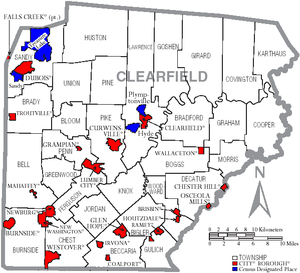 Map of Clearfield County, Pennsylvania with Municipal Labels, showing Cities and Boroughs (red), Townships (white), and Census-designated places (blue).
Under Pennsylvania law, there are four types of incorporated municipalities: cities, boroughs, townships, and, in at most two cases, towns. The following cities, boroughs and townships are located in Clearfield County:
Cities
Boroughs
Townships
- Beccaria Township
- Bell Township
- Bigler Township
- Bloom Township
- Boggs Township
- Bradford Township
- Brady Township
- Burnside Township
- Chest Township
- Cooper Township
- Covington Township
- Decatur Township
- Ferguson Township
- Girard Township
- Goshen Township
- Graham Township
- Greenwood Township
- Gulich Township
- Huston Township
- Jordan Township
- Karthaus Township
- Knox Township
- Lawrence Township
- Morris Township
- Penn Township
- Pike Township
- Pine Township
- Sandy Township
- Union Township
- Woodward Township
Census-designated places
Census-designated places are geographical areas designated by the U.S. Census Bureau for the purposes of compiling demographic data. They are not actual jurisdictions under Pennsylvania law. Other unincorporated communities, such as villages, may be listed here as well.
Recreation
There are two Pennsylvania state parks in Clearfield County.
Clearfield County is also home to the largest wild area in Pennsylvania, the Quehanna Wild Area. A culturally and historically significant natural formation of massive sandstone megaliths can be found at Bilger's rocks.
Education
Colleges and universities
- Lock Haven University of Pennsylvania at Clearfield, Pennsylvania
- Pennsylvania State University at DuBois, Pennsylvania
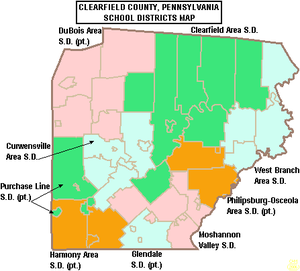 Map of Clearfield County, Pennsylvania Public School Districts
Community, Junior and Technical Colleges
- Clearfield County Career and Technology Center
- Dubois Business College
- Triangle Tech
Public School Districts
- Clearfield Area School District
- Curwensville Area School District
- DuBois Area School District
- Glendale School District
- Harmony Area School District
- Moshannon Valley School District
- Philipsburg-Osceola Area School District
- Purchase Line School District
- West Branch Area School District (also in Clinton County)
See also
- List of municipal authorities in Clearfield County, Pennsylvania
- Interstate 80 in Pennsylvania#Highest Point on 80
- Indian old field
- National Register of Historic Places listings in Clearfield County, Pennsylvania
References
- ^ "Find a County". National Association of Counties. http://www.naco.org/Counties/Pages/FindACounty.aspx. Retrieved 2011-06-07.
- ^ http://www.dos.state.pa.us/elections/lib/elections/055_voter_registration_statistics/currentstats/currentvotestats.xls
- ^ http://factfinder2.census.gov
- ^ http://mapserver.lib.virginia.edu/
- ^ "American FactFinder". United States Census Bureau. http://factfinder.census.gov. Retrieved 2008-01-31.
External links
Municipalities and communities of Clearfield County, Pennsylvania County seat: Clearfield City 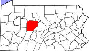
Boroughs Brisbin | Burnside | Chester Hill | Clearfield | Coalport | Curwensville | Falls Creek‡ | Glen Hope | Grampian | Houtzdale | Irvona | Lumber City | Mahaffey | New Washington | Newburg | Osceola Mills | Ramey | Troutville | Wallaceton | Westover
Townships CDPs Hyde | Plymptonville | Sandy | Treasure Lake
Other
communitiesHelvetia | Sylvan Grove | West Decatur
Footnotes ‡This populated place also has portions in an adjacent county or counties
Categories:- Pennsylvania counties
- Clearfield County, Pennsylvania
- 1804 establishments in the United States
- Populated places established in 1804


Wikimedia Foundation. 2010.