- Mercer County, Pennsylvania
-
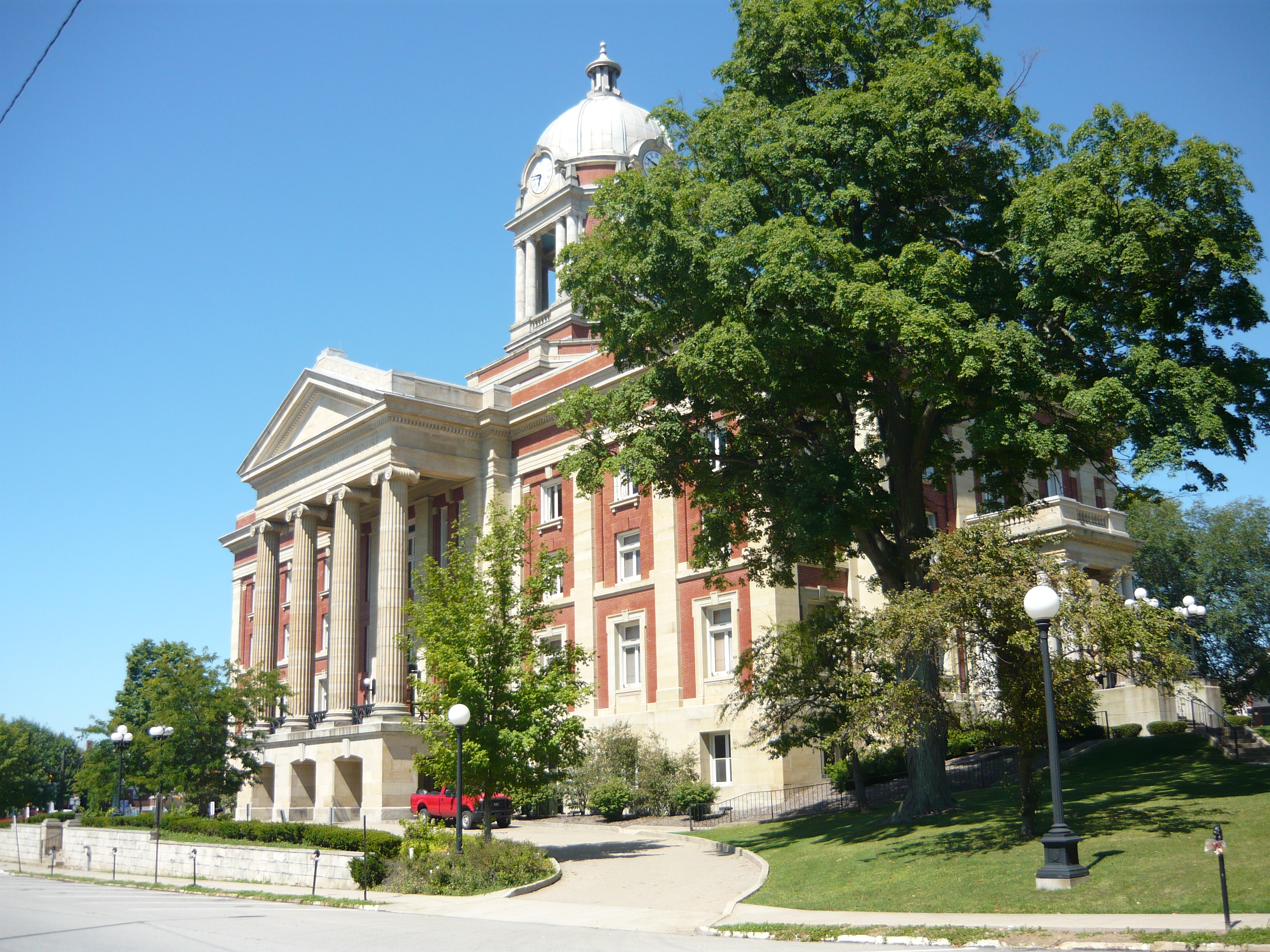
Mercer County, Pennsylvania  Mercer County Courthouse (1909)
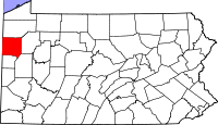
Location in the state of Pennsylvania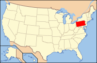
Pennsylvania's location in the U.S.Founded March 12, 1800 Seat Mercer Largest city Hermitage Area
- Total
- Land
- Water
683 sq mi (1,769 km²)
672 sq mi (1,740 km²)
11 sq mi (28 km²), 1.58%Population
- (2010)
- Density
116,638
174/sq mi (67/km²)Website www.mcc.co.mercer.pa.us Mercer County is a county located in the U.S. state of Pennsylvania. As of 2010, the population was 116,638. Its county seat is Mercer;[1] Sharon is its largest city.
Mercer County was part of the Sharon MSA as designated by the U.S. Census Bureau until the 2000 census, when it was appended to the Youngstown-Warren-Boardman, OH-PA MSA.
Contents
Geography
According to the U.S. Census Bureau, the county has a total area of 683 square miles (1,768 km²), of which 672 square miles (1,740 km²) is land and 11 square miles (28 km²) (1.58%) is water.
Adjacent counties
- Crawford County (north)
- Venango County (east)
- Butler County (southeast)
- Lawrence County (south)
- Mahoning County, Ohio (southwest)
- Trumbull County, Ohio (west)
Demographics
Historical populations Census Pop. %± 1800 3,228 — 1810 8,277 156.4% 1820 11,681 41.1% 1830 19,729 68.9% 1840 32,873 66.6% 1850 33,172 0.9% 1860 36,856 11.1% 1870 49,977 35.6% 1880 56,161 12.4% 1890 55,744 −0.7% 1900 57,387 2.9% 1910 77,699 35.4% 1920 93,788 20.7% 1930 99,246 5.8% 1940 101,039 1.8% 1950 111,954 10.8% 1960 127,519 13.9% 1970 127,175 −0.3% 1980 128,299 0.9% 1990 121,003 −5.7% 2000 120,307 −0.6% 2010 116,638 −3.0% [2][3] As of the census[4] of 2000, there were 120,293 people, 46,712 households, and 32,371 families residing in the county. The population density was 179 people per square mile (69/km²). There were 49,859 housing units at an average density of 74 per square mile (29/km²). The racial makeup of the county was 93.13% White, 5.25% Black or African American, 0.11% Native American, 0.40% Asian, 0.02% Pacific Islander, 0.17% from other races, and 0.91% from two or more races. 0.67% of the population were Hispanic or Latino of any race. 24.5% were of German, 12.0% Italian, 10.5% Irish, 9.3% English and 6.8% American ancestry according to Census 2000.
There were 46,712 households out of which 29.30% had children under the age of 18 living with them, 54.80% were married couples living together, 10.90% had a female householder with no husband present, and 30.70% were non-families. 27.00% of all households were made up of individuals and 13.20% had someone living alone who was 65 years of age or older. The average household size was 2.44 and the average family size was 2.96.
In the county, the population was spread out with 23.40% under the age of 18, 8.90% from 18 to 24, 26.10% from 25 to 44, 23.50% from 45 to 64, and 18.10% who were 65 years of age or older. The median age was 40 years. For every 100 females there were 94.70 males. For every 100 females age 18 and over, there were 90.80 males.
Government and politics
As of November 2008, there are 80,917 registered voters in Mercer County.[5]
- Democratic: 39,956 (49.38%)
- Republican: 32,103 (39.67%)
- Other Parties: 8,858 (10.95%)
Political bellwether
Mercer County was previously considered a political bellwether for the state of Pennsylvania since its demographics, urban/rural ratio, and party affiliation once closely mirrored the state as a whole. In 2000 Al Gore carried it against George W. Bush. This trend failed to hold true during the most recent 2004 Presidential election and 2008 Presidential election, in which Mercer County voted more conservatively than the rest of the state. In 2004 George W. Bush won Mercer County with 51% of the vote. That year John Kerry won the state as a whole with 51% of the popular vote. In 2008 John McCain won Mercer County by fewer than 200 votes with John McCain and Barack Obama each receiving roughly 49% of the popular vote. Barack Obama won the state of Pennsylvania as a whole with 55% of the popular vote. Each of the three state row office winners also carried Mercer in 2008.
County commissioners
- Matt McConnell, Chairman, Republican
- Brian Beader, Democrat
- John Lechner, Republican
Other county offices
- District Attorney, Robert G. Kochems, Democrat
- Prothonotary, Elizabeth F. Fair, Democrat
- Recorder of Deeds, Deedee Zickar, Republican
- Sheriff, William H. Romine, Jr., Democrat
- Treasurer, Virginia Richardson, Republican
State Representative
- Mark Longietti, Democrat, 7th district
- Dick Stevenson, Republican, 8th district
- Michele Brooks, Republican, 17th district
State Senator
- Robert D. Robbins, Republican, 50th district
US Representatives
- Mike Kelly (Pennsylvania), Republican, 3rd district
- Jason Altmire, Democrat, 4th district
Municipalities
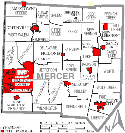
 Map of Mercer County, Pennsylvania with Municipal Labels showing Cities and Boroughs (red) and Townships (white).
Under Pennsylvania law, there are four types of incorporated municipalities: cities, boroughs, townships, and, in one case, towns. The following cities, boroughs and townships are located in Mercer County:
Cities
Boroughs
Townships
- Coolspring Township
- Deer Creek Township
- Delaware Township
- East Lackawannock Township
- Fairview Township
- Findley Township
- French Creek Township
- Greene Township
- Hempfield Township
- Jackson Township
- Jefferson Township
- Lackawannock Township
- Lake Township
- Liberty Township
- Mill Creek Township
- New Vernon Township
- Otter Creek Township
- Perry Township
- Pine Township
- Pymatuning Township
- Salem Township
- Sandy Creek Township
- Sandy Lake Township
- Shenango Township
- South Pymatuning Township
- Springfield Township
- Sugar Grove Township
- West Salem Township
- Wilmington Township
- Wolf Creek Township
- Worth Township
Education
Higher Education
- Grove City College (Grove City)
- Thiel College (Greenville)
- Pennsylvania State University, Shenango Campus (Sharon)
Career-Based Education
- Business Institute of Pennsylvania, Sharon
- Mercer County Career and Technical Center, Mercer
- Penn State Cosmetology Academy, Hermitage
- Sharon Regional Health System Schools of Nursing and Radiology, Sharon
- Winner Institute of Arts and Sciences, Transfer
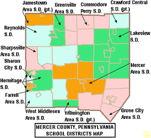 Map of Mercer County, Pennsylvania Public School Districts
Public School Districts
- Crawford Central School District
- Commodore Perry School District
- Farrell Area School District
- Greenville Area School District
- Grove City Area School District
- Hermitage School District
- Jamestown Area School District
- Lakeview School District
- Mercer Area School District
- Reynolds School District
- Sharon City School District
- Sharpsville Area School District
- West Middlesex Area School District
- Wilmington Area School District
Charter Schools
- Keystone Education Center Charter School [6], Greenville, PA. 256 pupils grades 7-12 Report Card 2010.[7]
Recreation and tourism
There is one Pennsylvania state park in Mercer County. Maurice K. Goddard State Park, named for Maurice K. Goddard, former Secretary of the Pennsylvania Department of Environmental Resources, is just off exit 130 of Interstate 79 on Pennsylvania Route 358 near Stoneboro.
The Wendell August Forge, the last remaining working forge in the state, was open to the public for tours, but it burned down on March 6, 2010.[8]
See also
- List of municipal authorities in Mercer County, Pennsylvania
- National Register of Historic Places listings in Mercer County, Pennsylvania
References
- ^ "Find a County". National Association of Counties. http://www.naco.org/Counties/Pages/FindACounty.aspx. Retrieved 2011-06-07.
- ^ http://factfinder2.census.gov
- ^ http://mapserver.lib.virginia.edu/
- ^ "American FactFinder". United States Census Bureau. http://factfinder.census.gov. Retrieved 2008-01-31.
- ^ http://www.dos.state.pa.us/elections/lib/elections/055_voter_registration_statistics/currentstats/currentvotestats.xls
- ^ Pennsylvania Department of Education (2011). "Charter Schools". http://www.portal.state.pa.us/portal/server.pt/community/charter_schools/7356.
- ^ http://paayp.emetric.net/Content/reportcards/RC10S104432830000007506.PDF
- ^ "Landmark metal forge burns in Mercer County." Pittsburgh Post-Gazette. Online. March 06, 2010.
External links
Municipalities and communities of Mercer County, Pennsylvania Cities 
Boroughs Clark | Fredonia | Greenville | Grove City | Jackson Center | Jamestown | Mercer | New Lebanon | Sandy Lake | Sharpsville | Sheakleyville | Stoneboro | West Middlesex | Wheatland
Townships Coolspring | Deer Creek | Delaware | East Lackawannock | Fairview | Findley | French Creek | Greene | Hempfield | Jackson | Jefferson | Lackawannock | Lake | Liberty | Mill Creek | New Vernon | Otter Creek | Perry | Pine | Pymatuning | Salem | Sandy Creek | Sandy Lake | Shenango | South Pymatuning | Springfield | Sugar Grove | West Salem | Wilmington | Wolf Creek | Worth
Categories:- Pennsylvania counties
- Mercer County, Pennsylvania
- 1800 establishments in the United States
- Youngstown metropolitan area
- Populated places established in 1800


Wikimedia Foundation. 2010.