- National Register of Historic Places listings in Mercer County, Pennsylvania
-
 Location of Mercer County in Pennsylvania
This is a list of the National Register of Historic Places listings in Mercer County, Pennsylvania.
This is intended to be a complete list of the properties and districts on the National Register of Historic Places in Mercer County, Pennsylvania, United States. The locations of National Register properties and districts for which the latitude and longitude coordinates are included below, may be seen in a Google map.[1]
There are 15 properties and districts listed on the National Register in the county.
-
- This National Park Service list is complete through NPS recent listings posted November 10, 2011.[2]
Current listings
[3] Landmark name[4] Image Date listed Location City or Town Summary 1 Wendell August Forge November 7, 1996 620 Madison Street
41°9′57″N 80°3′51″W / 41.16583°N 80.06417°WGrove City 2 Big Bend Historical Area April 21, 1975 6 miles (9.7 km) northwest of Mercer on the Shenango River
41°17′33″N 80°19′36″W / 41.2925°N 80.32667°WMercer 3 Bridge in French Creek Township 
June 22, 1988 Legislative Route 43074 over French Creek
41°28′17″N 80°1′7″W / 41.47139°N 80.01861°WCarlton 4 Frank H. Buhl Mansion December 2, 1977 422 East State Street
41°13′56″N 80°29′58″W / 41.23222°N 80.49944°WSharon 5 First Universalist Church of Sharpsville May 29, 2003 131 North Mercer Avenue
41°15′59″N 80°28′33″W / 41.26639°N 80.47583°WSharpsville 6 Gibson House December 1, 1978 210 Liberty Street
41°29′5″N 80°26′24″W / 41.48472°N 80.44°WJamestown 7 Greenville Commercial Historic District August 10, 2000 Centered on Main, Canal, and Clinton Streets
41°24′26″N 80°23′20″W / 41.40722°N 80.38889°WGreenville 8 Johnston's Tavern March 24, 1972 6 miles (9.7 km) south of Mercer on U.S. Route 19
41°8′59″N 80°13′22″W / 41.14972°N 80.22278°WMercer 9 Kidd's Mills Covered Bridge Historic District 
December 2, 1974 5 miles (8.0 km) south of Greenville off Pennsylvania Route 58
41°21′15″N 80°23′48″W / 41.35417°N 80.39667°WGreenville 10 Christiana Lindsey House January 15, 1998 313 East Butler Street
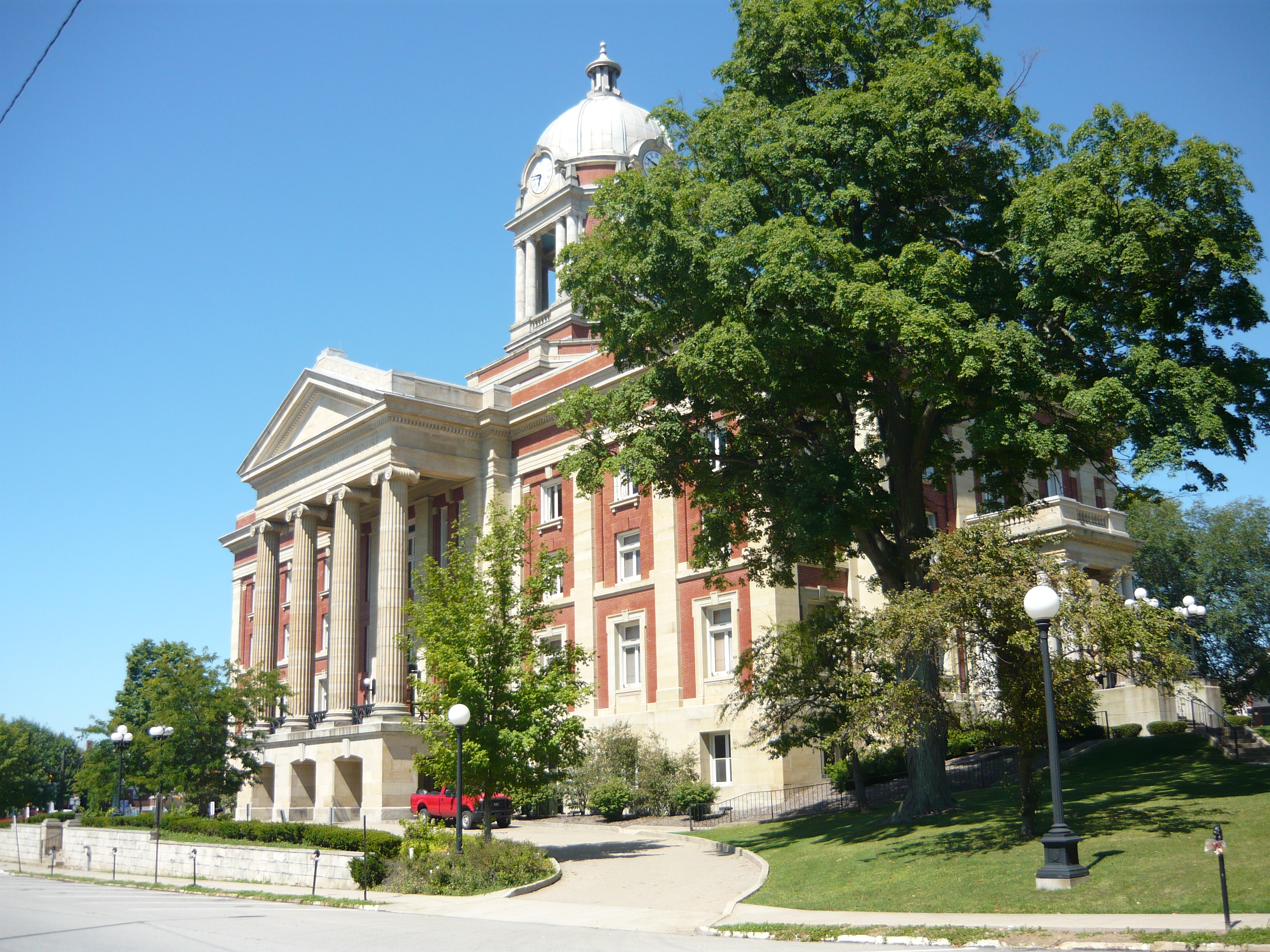
41°13′31″N 80°14′7″W / 41.22528°N 80.23528°WMercer 11 Mercer County Court House 
November 12, 1998 Roughly along Diamond, Erie and Pitt Streets
41°13′36″N 80°12′49″W / 41.22667°N 80.21361°WMercer 12 New Hamburg Historical Area December 2, 1974 7 miles south of Greenville off Pennsylvania Route 58
41°19′14″N 80°20′17″W / 41.32056°N 80.33806°WGreenville 13 Jonas J. Pierce House October 24, 1996 18 East Shenango Street
41°15′57″N 80°28′12″W / 41.26583°N 80.47°WSharpsville 14 Quaker Bridge 
June 22, 1988 Legislative Route 43135 over the Little Shenango River
41°25′33″N 80°22′22″W / 41.42583°N 80.37278°WGreenville 15 Alexander P. and James South Waugh House April 23, 1998 23 West Main Street
41°24′8″N 80°19′31″W / 41.40222°N 80.32528°WGreenville See also
- List of National Historic Landmarks in Pennsylvania
- National Register of Historic Places listings in Pennsylvania
- List of Pennsylvania state historical markers in Mercer County
References
- ^ The latitude and longitude information provided in this table was derived originally from the National Register Information System, which has been found to be fairly accurate for about 99% of listings. For about 1% of NRIS original coordinates, experience has shown that one or both coordinates are typos or otherwise extremely far off; some corrections may have been made. A more subtle problem causes many locations to be off by up to 150 yards, depending on location in the country: most NRIS coordinates were derived from tracing out latitude and longitudes off of USGS topographical quadrant maps created under North American Datum of 1927, which differs from the current, highly accurate GPS system used by Google maps. Chicago is about right, but NRIS longitudes in Washington are higher by about 4.5 seconds, and are lower by about 2.0 seconds in Maine. Latitudes differ by about 1.0 second in Florida. Some locations in this table may have been corrected to current GPS standards.
- ^ "National Register of Historic Places: Weekly List Actions". National Park Service, United States Department of the Interior. Retrieved on November 10, 2011.
- ^ Numbers represent an ordering by significant words. Various colorings, defined here, differentiate National Historic Landmark sites and National Register of Historic Places Districts from other NRHP buildings, structures, sites or objects.
- ^ "NPS Focus". National Register of Historic Places. National Park Service. http://nrhp.focus.nps.gov. Retrieved November 20, 2009.
Municipalities and communities of Mercer County, Pennsylvania County seat: Mercer Cities 
Boroughs Clark | Fredonia | Greenville | Grove City | Jackson Center | Jamestown | Mercer | New Lebanon | Sandy Lake | Sharpsville | Sheakleyville | Stoneboro | West Middlesex | Wheatland
Townships Coolspring | Deer Creek | Delaware | East Lackawannock | Fairview | Findley | French Creek | Greene | Hempfield | Jackson | Jefferson | Lackawannock | Lake | Liberty | Mill Creek | New Vernon | Otter Creek | Perry | Pine | Pymatuning | Salem | Sandy Creek | Sandy Lake | Shenango | South Pymatuning | Springfield | Sugar Grove | West Salem | Wilmington | Wolf Creek | Worth
Categories:- Mercer County, Pennsylvania
- National Register of Historic Places in Pennsylvania by county
-


Wikimedia Foundation. 2010.