- National Register of Historic Places listings in Northeast Philadelphia
-
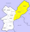
 Location of Northeast Philadelphia in Philadelphia
This is a list of the National Register of Historic Places listings in Northeast Philadelphia.
This is intended to be a complete list of the properties and districts on the National Register of Historic Places in Northeast Philadelphia, Pennsylvania, United States. The locations of National Register properties and districts for which the latitude and longitude coordinates are included below, may be seen in a Google map.[1]
There are 532 properties and districts listed on the National Register in Philadelphia, including 67 National Historic Landmarks. Northeast Philadelphia includes 52 of these properties and districts, including 1 National Historic Landmark; the city's remaining properties and districts are listed elsewhere. One site is split between Northeast Philadelphia and other parts of the city, and is thus included on multiple lists.
Current listings
[2] Landmark name[3] Image Date listed Location Neighborhood[4] Summary 1 26th District Police and Patrol Station 
July 12, 1984 2136–2142 East Dauphin Street
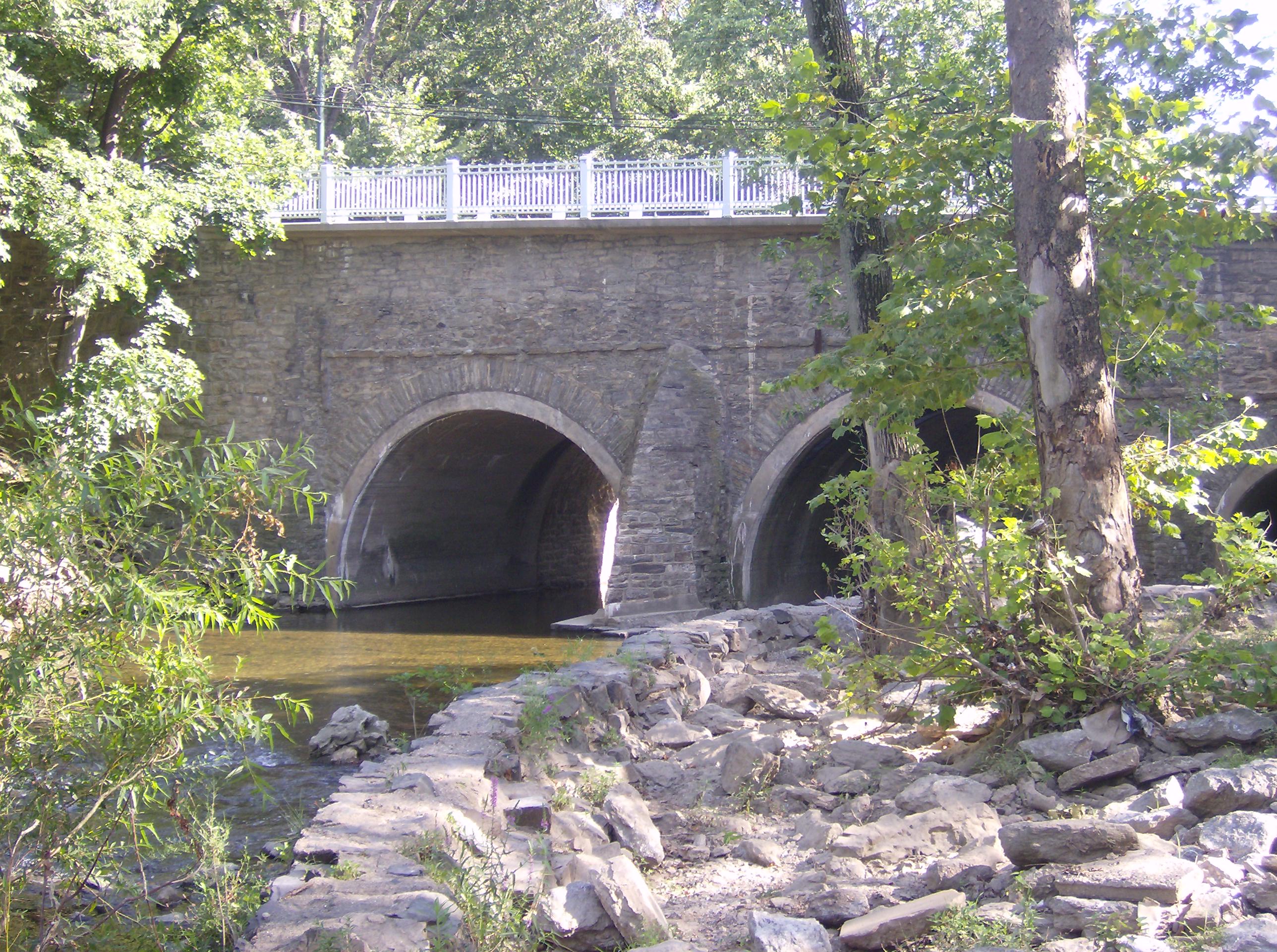
39°58′51.5″N 75°7′44.5″W / 39.980972°N 75.129028°WKensington 2 Adams Avenue Bridge in Philadelphia 
June 22, 1988 Adams Avenue over Tacony Creek
40°2′31″N 75°6′48″W / 40.04194°N 75.11333°WOlney Extends into North Philadelphia 3 Ethan Allen School 
November 18, 1988 3001 Robbins Avenue
40°1′47″N 75°3′44″W / 40.02972°N 75.06222°WMayfair 4 William W. Axe School 
November 18, 1988 1709–1733 Kinsey Street
40°0′44″N 75°5′2″W / 40.01222°N 75.08389°WFrankford 5 Beatty's Mills Factory Building 
August 18, 2004 2446–2468 Coral Street
39°59′4″N 75°7′43″W / 39.98444°N 75.12861°WKensington 6 Bridesburg School 
April 10, 1989 2624 Haworth Street
40°0′10″N 75°4′5″W / 40.00278°N 75.06806°WBridesburg 7 Joseph H. Brown School 
November 18, 1988 8118–8120 Frankford Avenue
40°2′36″N 75°1′29″W / 40.04333°N 75.02472°WHolmesburg 8 H.W. Butterworth and Sons Company Building 
June 28, 2010 2410 East York St.
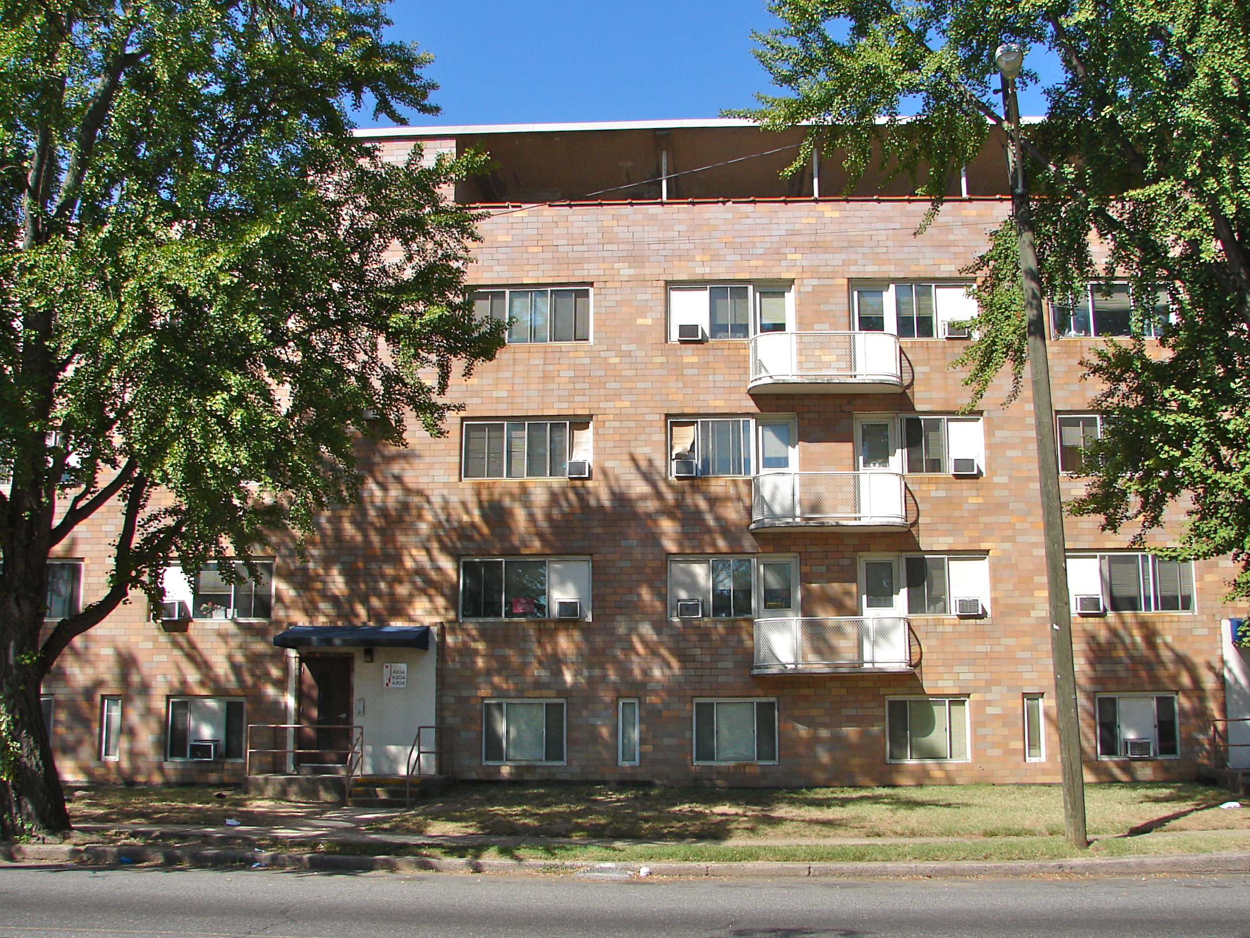
39°58′39″N 75°7′29″W / 39.9775°N 75.12472°WKensington 9 Carl Mackley Houses 
May 6, 1998 1401 East Bristol Street
40°0′44″N 75°5′55″W / 40.01222°N 75.09861°WJuniata 10 Laura H. Carnell School 
November 18, 1988 6101 Summerdale Avenue
40°2′20″N 75°5′3″W / 40.03889°N 75.08417°WOxford Circle 11 Watson Comly School 
November 18, 1988 13250 Trevose Road
40°7′36″N 75°0′46″W / 40.12667°N 75.01278°WSomerton 12 Russell H. Conwell School 
November 18, 1988 1829–1951 East Clearfield Street
39°59′39″N 75°6′54″W / 39.99417°N 75.115°WPort Richmond 13 Thomas Creighton School 
November 18, 1988 5401 Tabor Road
40°2′4″N 75°6′19″W / 40.03444°N 75.10528°WCrescentville 14 Kennedy Crossan School 
November 18, 1988 7341 Palmetto Street
40°3′43″N 75°4′54″W / 40.06194°N 75.08167°WBurholme 15 Hamilton Disston School 
November 18, 1988 6801 Cottage Street
40°1′42″N 75°2′50″W / 40.02833°N 75.04722°WTacony 16 Mary Disston School 
November 18, 1988 4521 Longshore Avenue
40°1′42″N 75°2′40″W / 40.02833°N 75.04444°WTacony 17 Henry R. Edmunds School 
November 18, 1988 1101–1197 Haworth Street
40°1′30″N 75°5′12″W / 40.025°N 75.08667°WNorthwood 18 Fayette School 
December 4, 1986 Old Bustleton and Welsh Roads
40°4′56″N 75°2′20″W / 40.08222°N 75.03889°WBustleton 19 Edwin Forrest School 
November 18, 1988 4300 Bleigh Street
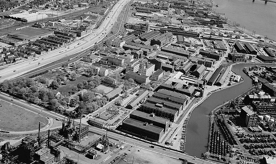
40°2′4″N 75°2′9.5″W / 40.03444°N 75.035972°WMayfair 20 Frankford Arsenal 
March 16, 1972 Tacony and Bridge Streets
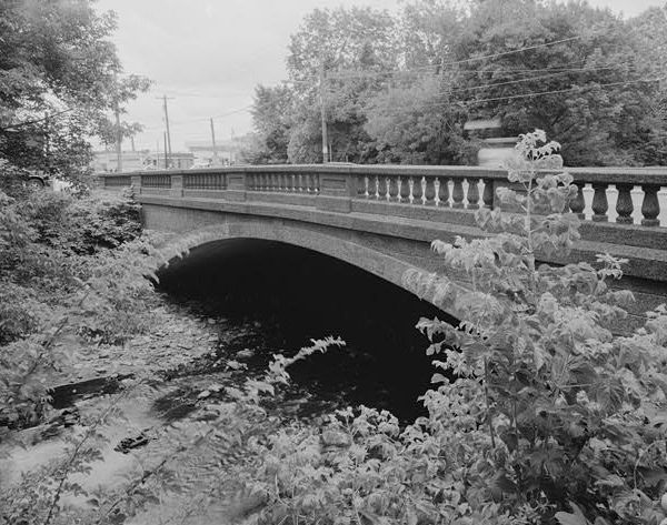
40°0′28″N 75°4′0″W / 40.00778°N 75.066667°WFrankford 21 Frankford Avenue Bridge 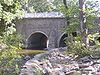
June 22, 1988 Frankford Avenue over the Pennypack Creek
40°2′36.8″N 75°1′13.9″W / 40.043556°N 75.020528°WHolmesburg 22 Frankford Avenue Bridge 
June 22, 1988 Frankford Avenue over Poquessing Creek
40°3′52.5″N 74°58′53″W / 40.064583°N 74.98139°WTorresdale Extends into Bucks County 23 Benjamin Franklin School 
November 18, 1988 5737–5741 Rising Sun Avenue
40°2′33″N 75°6′15″W / 40.0425°N 75.10417°WCrescentville 24 Friends Hospital 
January 20, 1999 4641 Roosevelt Boulevard
40°1′36″N 75°6′7″W / 40.02667°N 75.10194°WNorthwood 25 Glen Foerd at Torresdale 
November 20, 1979 5001 Grant Avenue
40°3′5″N 74°58′44″W / 40.05139°N 74.97889°WTorresdale 26 Greenbelt Knoll Historic District 
December 14, 2010 1–19 Longford St., roughly bounded by Holme Ave. and Pennypack Park Greenway
40°3′23″N 75°1′20″W / 40.05639°N 75.02222°WPennypack 27 Green Tree Tavern 
June 27, 1980 260–262 East Girard Avenue
39°58′10.5″N 75°7′54.5″W / 39.969583°N 75.131806°WFishtown 28 Warren G. Harding Junior High School 
November 18, 1988 2000 Wakeling Street
40°0′47″N 75°4′28″W / 40.01306°N 75.07444°WFrankford 29 Holme Avenue Bridge 
June 22, 1988 Holme Avenue over Wooden Bridge Run
40°3′23.5″N 75°1′27.5″W / 40.056528°N 75.024306°WPennypack 30 Francis Hopkinson School 
November 18, 1988 1301–1331 East Luzerne Avenue
40°0′30″N 75°6′8.5″W / 40.00833°N 75.102361°WJuniata 31 George L. Horn School 
December 4, 1986 Frankford and Castor Avenues
39°59′58″N 75°5′54.5″W / 39.99944°N 75.098472°WPort Richmond 32 John Paul Jones Junior High School 
November 18, 1988 2922 Memphis Street
39°59′10″N 75°6′46″W / 39.98611°N 75.11278°WPort Richmond 33 Kensington High School for Girls 
November 18, 1988 2075 East Cumberland Street
39°59′3″N 75°7′35″W / 39.98417°N 75.12639°WKensington 34 Knowlton 
October 1, 1974 8001 Verree Road
40°4′23.5″N 75°4′28″W / 40.073194°N 75.07444°WFox Chase 35 Lawndale School 
November 18, 1988 600 Hellerman Street
40°2′58.5″N 75°5′31″W / 40.049583°N 75.09194°WLawndale 36 Henry Longfellow School 
November 18, 1988 5004–5098 Tacony Street
40°0′30.5″N 75°4′17″W / 40.008472°N 75.07139°WFrankford 37 John Marshall School 
November 18, 1988 1501–1527 Sellers Street
40°0′52.5″N 75°5′15″W / 40.014583°N 75.0875°WFrankford 38 James Martin School 
November 18, 1988 3340 Richmond Street
39°59′8″N 75°5′49.5″W / 39.98556°N 75.097083°WPort Richmond 39 Mechanicsville School 
December 1, 1986 Mechanicsville Road
40°6′26.5″N 74°58′1.5″W / 40.107361°N 74.967083°WParkwood 40 Penn Treaty Junior High School 
November 18, 1988 600 East Thompson Street
39°58′22″N 75°7′38″W / 39.97278°N 75.12722°WFishtown 41 Thomas Powers School 
December 4, 1986 Frankford Avenue and Somerset Street
39°59′19.5″N 75°7′11″W / 39.98875°N 75.11972°WPort Richmond 42 Richmond School 
November 18, 1988 2942 Belgrade Street
39°59′0″N 75°6′38″W / 39.983333°N 75.11056°WPort Richmond 43 John Ruan House 
October 31, 1985 4278–4280 Griscom Street
40°0′40″N 75°5′25″W / 40.01111°N 75.09028°WFrankford 44 Ryerss Mansion 
November 21, 1976 Central and Cottman Avenues
40°4′7″N 75°5′19″W / 40.06861°N 75.08861°WFox Chase 45 Philip H. Sheridan School 
November 18, 1988 800–818 East Ontario Street
39°59′58.5″N 75°6′51″W / 39.999583°N 75.11417°WKensington 46 Franklin Smedley School 
November 18, 1988 5199 Mulberry Street
40°1′11″N 75°4′26″W / 40.01972°N 75.07389°WFrankford 47 Stanley 
May 10, 2005 8500 Pine Road
40°5′25″N 75°4′29″W / 40.09028°N 75.07472°WFox Chase Extends into Montgomery County 48 James J. Sullivan School 
November 18, 1988 5300 Ditman Street
40°0′57.5″N 75°4′0″W / 40.015972°N 75.066667°WFrankford 49 Tacony Music Hall 
March 9, 1990 4815–4819 Longshore Avenue
40°1′28.5″N 75°2′31.5″W / 40.024583°N 75.042083°WTacony 50 Francis E. Willard School 
December 4, 1986 Emerald and Orleans Streets
39°59′30″N 75°7′1″W / 39.99167°N 75.11694°WPort Richmond 51 David Wilmot School 
November 18, 1988 1734 Meadow Street
40°0′49.6″N 75°4′51″W / 40.013778°N 75.08083°WFrankford 52 Woodrow Wilson Junior High School 
December 4, 1986 Cottman Avenue and Loretto Street
40°3′8.5″N 75°4′8.5″W / 40.052361°N 75.069028°WCastor Gardens[5] See also
- List of National Historic Landmarks in Philadelphia
- National Register of Historic Places listings in Philadelphia, Pennsylvania
References
- ^ The latitude and longitude information provided in this table was derived originally from the National Register Information System, which has been found to be fairly accurate for about 99% of listings. For about 1% of NRIS original coordinates, experience has shown that one or both coordinates are typos or otherwise extremely far off; some corrections may have been made. A more subtle problem causes many locations to be off by up to 150 yards, depending on location in the country: most NRIS coordinates were derived from tracing out latitude and longitudes off of USGS topographical quadrant maps created under the North American Datum of 1927, which differs from the current, highly accurate WGS84 GPS system used by Google maps. Chicago is about right, but NRIS longitudes in Washington are higher by about 4.5 seconds, and are lower by about 2.0 seconds in Maine. Latitudes differ by about 1.0 second in Florida. Some locations in this table may have been corrected to current GPS standards.
- ^ Numbers represent an ordering by significant words. Various colorings, defined here, differentiate National Historic Landmark sites and National Register of Historic Places Districts from other NRHP buildings, structures, sites or objects.
- ^ "NPS Focus". National Register of Historic Places. National Park Service. http://nrhp.focus.nps.gov. Retrieved November 20, 2009.
- ^ "The Political and Community Service Boundaries of Philadelphia" (PDF). Philadelphia City Planning Commission. June 2004. http://www.philaplanning.org/data/boundaries.pdf.
- ^ McMullin, Robert J. (1975). The Neighborhoods of Philadelphia. Philadelphia, Pennsylvania: Office of the Deputy Managing Director for Housing. pp. 118. "Oxford Circle: Oxford Circle of Comly Street to Cottman Avenue, Roosevelt Boulevard to Oxford Avenue and Algon Avenue. ...the Castor Gardens section from about Magee to Cottman is generally more prestigious than the south end."
Neighborhoods of the Northeast section of Philadelphia, Pennsylvania Academy Gardens • Ashton-Woodenbridge • Bridesburg • Burholme • Bustleton • Byberry • Castor Gardens • Crescentville • Crestmont Farms • Fishtown • Fox Chase • Frankford • Harrowgate • Holme Circle • Holmesburg • Juniata • Kensington • Lawndale • Lexington Park • Mayfair • Millbrook • Modena Park • Morrell Park • Normandy • Oxford Circle • Parkwood • Pennypack • Port Richmond • Rhawnhurst • Ryers • Somerton • Tacony • Torresdale • Upper Holmesburg • Winchester Park • Wissinoming
 Categories:
- Buildings and structures in Philadelphia, Pennsylvania
- National Register of Historic Places in Philadelphia, Pennsylvania


Wikimedia Foundation. 2010.