Modena Park, Philadelphia, Pennsylvania

Modena Park, Philadelphia, Pennsylvania

Contents

Modena Park

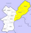
is a neighborhood in Northeast Philadelphia. It is located east of Northeast Philadelphia Airport at Morrell Avenue. [1]

The ground was owned by the estate of William Dudley in 1910. The neighborhood was built around 1960-1963, and features short blocks of two story rowhouses with basements. This neighborhood borders Morrell Park, Philadelphia, Pennsylvania to its south. Parkwood, Philadelphia, Pennsylvania to its north. Walton Run woods to the west, and Millbrook, Philadelphia, Pennsylvania, to its east.

Education

Public-

General Harry LaBrum Middle School 10858 Hawley Rd, Philadelphia, PA 19154

Philadelphia Archdiocese-

Archbishop Ryan High School 11260 Academy Rd, Philadelphia, PA, 19154

St. Marthas School 11452 Academy Rd, Philadelphia, PA,

Recreation

Picariello Playground 10811 Calera Rd, Philadelphia, PA 19154

Liberty Bell Youth Organization Red Lion & Calera Rds Road, Philadelphia, PA 19114

Philadelphia Soccer Club 10402 Decatur Road, Philadelphia, PA 19154

References

Coordinates: 40°04′42″N 74°59′17″W / 40.078444°N 74.987947°W / 40.078444; -74.987947


Wikimedia Foundation. 2010.

Игры ⚽ Нужно сделать НИР?

Look at other dictionaries:

  • Morrell Park, Philadelphia, Pennsylvania — Morrell Park is a neighborhood located in the Northeast section of Philadelphia, Pennsylvania, United States. It is located on the eastern side of the Far Northeast, north of Grant Avenue and east of Northeast Philadelphia Airport. Contents 1… …   Wikipedia

  • Oxford Circle, Philadelphia, Pennsylvania — Not to be confused with Oxford Circus. Oxford Circle is a neighborhood in the lower Northeast section of Philadelphia, Pennsylvania, United States. Its namesake is the much used traffic circle 40°01′53″N 75°05′04″W …   Wikipedia

  • Crestmont Farms, Philadelphia, Pennsylvania — Crestmont Farms is an affluent small residential neighborhood in the Northeast section of Philadelphia, Pennsylvania. It is located along the Bucks County line, at Poquessing Creek, east of Knights Road. The housing consists of single homes.… …   Wikipedia

  • Mayfair, Philadelphia, Pennsylvania — The intersection of Frankford and Cottman Avenues in Mayfair Mayfair is a neighborhood located in the Lower Northeast section of Philadelphia, Pennsylvania centered on the intersection of Cottman and Frankford Avenues.[1] It is bordered by Tacony …   Wikipedia

  • Millbrook, Philadelphia, Pennsylvania — Millbrook, also known as Chalfont, is a neighbourhood in the Northeast section of Philadelphia, Pennsylvania, United States. The neighborhood is adjacent to Franklin Mills.The neighborhood consists of row homes, twin and twin rancher homes and… …   Wikipedia

  • Lawncrest, Philadelphia, Pennsylvania — Lawncrest is a neighborhood in the Near (lower) Northeast Philadelphia, Pennsylvania. The name is an amalgram of Lawndale and Crescentville, the two primary communities that make up the neighborhood. The community can trace its roots back to the… …   Wikipedia

  • Normandy, Philadelphia, Pennsylvania — Normandy is a neighborhood in Northeast Philadelphia. It is located east of Roosevelt Boulevard, in the vicinity of Woodhaven and Byberry Roads, built in 1955 1956. All of the streets in this neighborhood begin with the letter N. The neighborhood …   Wikipedia

  • Crescentville, Philadelphia, Pennsylvania — Crescentville is a neighborhood in Northeast Philadelphia. It is located in the vicinity of Adams, Rising Sun, and Tabor Avenues.[1] Crescentville is referred to as the area bound by Tookany Creek to the South and West of Adams Avenue, up to the… …   Wikipedia

  • List of Pennsylvania locations by per capita income — Pennsylvania locations by per capita income is a list of all incorporated areas and census designated places in Pennsylvania ranked from highest capita income to lowest per capita income. There are many communities not on the list because they… …   Wikipedia

  • Northeast Philadelphia — Map of Philadelphia County with Northeast highlighted. Click for larger image …   Wikipedia

Share the article and excerpts

Direct link
Do a right-click on the link above
and select “Copy Link”