Normandy, Philadelphia, Pennsylvania
- Normandy, Philadelphia, Pennsylvania
-
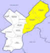
Normandy is a neighborhood in Northeast Philadelphia. It is located east of Roosevelt Boulevard, in the vicinity of Woodhaven and Byberry Roads, built in 1955- 1956. All of the streets in this neighborhood begin with the letter N. The neighborhood is made up of cape cod style single family homes, with frame construction. Most of the homes have received additions over the years. The original landowners were Joseph Buckman, who owned 73 acres (300,000 m2) and John Rieger, who owned 18 acres (73,000 m2). Kraft Foods currently operates the old Nabisco plant at the southwest corner of Roosevelt Boulevard and Byberry Road. Devon self-storage occupies what used to be Best products, also what was the original Normandy Square market.[1]
The Northeast Village was a wartime military housing project just south of the present Normandy Village.
References
Categories:
- Philadelphia, Pennsylvania stubs
- Neighborhoods in Philadelphia, Pennsylvania
Wikimedia Foundation.
2010.
Look at other dictionaries:
Mayfair, Philadelphia, Pennsylvania — The intersection of Frankford and Cottman Avenues in Mayfair Mayfair is a neighborhood located in the Lower Northeast section of Philadelphia, Pennsylvania centered on the intersection of Cottman and Frankford Avenues.[1] It is bordered by Tacony … Wikipedia
Millbrook, Philadelphia, Pennsylvania — Millbrook, also known as Chalfont, is a neighbourhood in the Northeast section of Philadelphia, Pennsylvania, United States. The neighborhood is adjacent to Franklin Mills.The neighborhood consists of row homes, twin and twin rancher homes and… … Wikipedia
Lawncrest, Philadelphia, Pennsylvania — Lawncrest is a neighborhood in the Near (lower) Northeast Philadelphia, Pennsylvania. The name is an amalgram of Lawndale and Crescentville, the two primary communities that make up the neighborhood. The community can trace its roots back to the… … Wikipedia
Crescentville, Philadelphia, Pennsylvania — Crescentville is a neighborhood in Northeast Philadelphia. It is located in the vicinity of Adams, Rising Sun, and Tabor Avenues.[1] Crescentville is referred to as the area bound by Tookany Creek to the South and West of Adams Avenue, up to the… … Wikipedia
Somerton, Philadelphia, Pennsylvania — Somerton is located in the Far Northeast section of Philadelphia, Pennsylvania, United States. The neighborhood is generally bound by Tomlinson Road to the south, Roosevelt Boulevard to the east, East County Line Road and Poquessing Creek to the… … Wikipedia
Oxford Circle, Philadelphia, Pennsylvania — Not to be confused with Oxford Circus. Oxford Circle is a neighborhood in the lower Northeast section of Philadelphia, Pennsylvania, United States. Its namesake is the much used traffic circle 40°01′53″N 75°05′04″W … Wikipedia
Modena Park, Philadelphia, Pennsylvania — Contents 1 Modena Park 2 Education 3 Recreation 4 References Modena Park is a neighborhood in Northeast Philadelphia. It is lo … Wikipedia
Morrell Park, Philadelphia, Pennsylvania — Morrell Park is a neighborhood located in the Northeast section of Philadelphia, Pennsylvania, United States. It is located on the eastern side of the Far Northeast, north of Grant Avenue and east of Northeast Philadelphia Airport. Contents 1… … Wikipedia
Crestmont Farms, Philadelphia, Pennsylvania — Crestmont Farms is an affluent small residential neighborhood in the Northeast section of Philadelphia, Pennsylvania. It is located along the Bucks County line, at Poquessing Creek, east of Knights Road. The housing consists of single homes.… … Wikipedia
Northeast Village, Philadelphia, Pennsylvania — The Northeast Village was a wartime military housing project just south of the present Normandy Village, between Red Lion Rd. to the south, Decatur Rd. to the east, Comly Rd. to the north, and the Roosevelt Boulevard to the west. The land was… … Wikipedia
 Categories: