- National Register of Historic Places listings in Lehigh County, Pennsylvania
-
 Location of Lehigh County in Pennsylvania
This is a list of the National Register of Historic Places listings in Lehigh County, Pennsylvania.
This is intended to be a complete list of the properties and districts on National Register of Historic Places in Lehigh County, Pennsylvania. The locations of National Register properties and districts for which the latitude and longitude coordinates are included below, may be seen in a Google map.[1]
There are 53 properties and districts listed on the National Register in the county. One site is further designated as a National Historic Landmark. Another property was once listed but has been removed.
-
- This National Park Service list is complete through NPS recent listings posted November 10, 2011.[2]
Current listings
[3] Landmark name[4] Image Date listed Location City or Town Summary 1 Allentown Masonic Temple 
May 5, 2004 1524 West Linden Street
40°35′55″N 75°29′25″W / 40.59861°N 75.49028°WAllentown 2 Allentown National Bank 
December 28, 2005 13–17 N. 7th Street
40°36′17″N 75°28′17″W / 40.60472°N 75.47139°WAllentown 3 Americus Hotel 
August 23, 1984 541 Hamilton Street
40°36′10″N 75°28′12″W / 40.60278°N 75.47°WAllentown 4 Bethlehem Armory November 14, 1991 301 Prospect Street
40°37′9″N 75°23′16″W / 40.61917°N 75.38778°WBethlehem 5 Biery's Port Historic District August 9, 1984 Roughly bounded by Pineapple, Front, Race, and Mulberry Streets
40°38′57″N 75°28′4″W / 40.64917°N 75.46778°WCatasauqua 6 Bogert Covered Bridge December 1, 1980 South of Allentown on Legislative Route 39016 in Little Lehigh Park
40°34′8″N 75°30′17″W / 40.56889°N 75.50472°WAllentown 7 Bridge in Heidelberg Township June 22, 1988 Legislative Route 39110 over a branch of Jordan Creek
40°42′3″N 75°42′37″W / 40.70083°N 75.71028°WHeidelberg Township 8 Burnside Plantation May 2, 1990 Schoenersville Road 2 miles (3.2 km) southeast of its junction with Easton Avenue
40°37′51″N 75°23′22″W / 40.63083°N 75.38944°WBethlehem 9 Catasauqua Residential Historic District May 10, 1984 Roughly bounded by Howertown Road, Railroad Avenue, Oak and Bridge Streets
40°39′19″N 75°28′25″W / 40.65528°N 75.47361°WCatasauqua 10 Centennial Bridge 
June 22, 1988 Station Avenue over Saucon Creek
40°31′43″N 75°23′31″W / 40.52861°N 75.39194°WCenter Valley 11 Central Bethlehem Historic District 
May 5, 1972 Bounded by Main, Nevada, and East Broad Streets, and the river
40°37′6″N 75°22′56″W / 40.61833°N 75.38222°WBethlehem Extends into Northampton County 12 Cold Spring Bridge June 22, 1988 2nd Street over Spring Creek
40°42′3″N 75°31′1″W / 40.70083°N 75.51694°WNorth Whitehall and Whitehall Townships 13 Coopersburg Historic District April 26, 1982 Main Street and Pennsylvania Route 309
40°30′32″N 75°23′23″W / 40.50889°N 75.38972°WCoopersburg 14 Coplay Cement Company Kilns 
September 2, 1980 North 2nd Street
40°40′34″N 75°29′42″W / 40.67611°N 75.495°WCoplay 15 Dent Hardware Company Factory Complex August 21, 1986 1101 3rd Street
40°38′24″N 75°28′30″W / 40.64°N 75.475°WWhitehall Township 16 Dillingersville Union School and Church October 25, 1979 East of Zionsville on Zionsville Road
40°28′26″N 75°29′17″W / 40.47389°N 75.48806°WLower Milford Township 17 Dime Savings and Trust Company 
January 3, 1985 12 North 7th Street
40°36′8″N 75°28′22″W / 40.60222°N 75.47278°WAllentown 18 Dorneyville Crossroad Settlement December 7, 1977 South of Allentown at the junction of U.S. Route 222 and Pennsylvania Route 29
40°34′48″N 75°31′19″W / 40.58°N 75.52194°WAllentown 19 Jacob Jr. Ehrenhardt House November 7, 2003 55 South Keystone Avenue
40°32′23″N 75°29′11″W / 40.53972°N 75.48639°WEmmaus 20 Fireman's Drinking Fountain November 9, 1981 Main Street
40°45′6″N 75°36′48″W / 40.75167°N 75.61333°WSlatington 21 Fountain Hill Historic District April 21, 1988 Roughly bounded by Brighton, Wyandotte, W. 4th, and Seminole Streets, and Delaware Avenue
40°36′40″N 75°23′10″W / 40.61111°N 75.38611°WBethlehem Extends into Northampton County 22 Frantz's Bridge June 22, 1988 Legislative Route 39060 over Jordan Creek
40°39′3″N 75°39′2″W / 40.65083°N 75.65056°WLowhill Township 23 Gauff-Roth House 
September 5, 1985 427–443 Auburn Street
40°35′46″N 75°27′52″W / 40.59611°N 75.46444°WAllentown 24 Geiger Covered Bridge 
December 1, 1980 Southeast of Schencksville on Township 681
40°38′46″N 75°37′0″W / 40.64611°N 75.616667°WNorth Whitehall Township 25 Haines Mill September 11, 1981 Walnut Street and Main Boulevard
40°35′6″N 75°31′56″W / 40.585°N 75.53222°WAllentown 26 Helfrich's Springs Grist Mill October 14, 1977 West of Fullerton on Mickley Road
40°37′31″N 75°29′29″W / 40.62528°N 75.49139°WFullerton 27 High German Evangelical Reformed Church 
July 28, 1983 620 Hamilton Street
40°36′8″N 75°27′31″W / 40.60222°N 75.45861°WAllentown 28 Hotel Sterling 
May 3, 1984 343–345 Hamilton Street
40°36′19″N 75°27′43″W / 40.60528°N 75.46194°WAllentown 29 Kemmerer House September 14, 1977 3 Iroquois Street
40°32′55″N 75°30′3″W / 40.54861°N 75.50083°WEmmaus 30 Frederick and Catherine Leaser Farm January 14, 2004 7654 Leaser Road
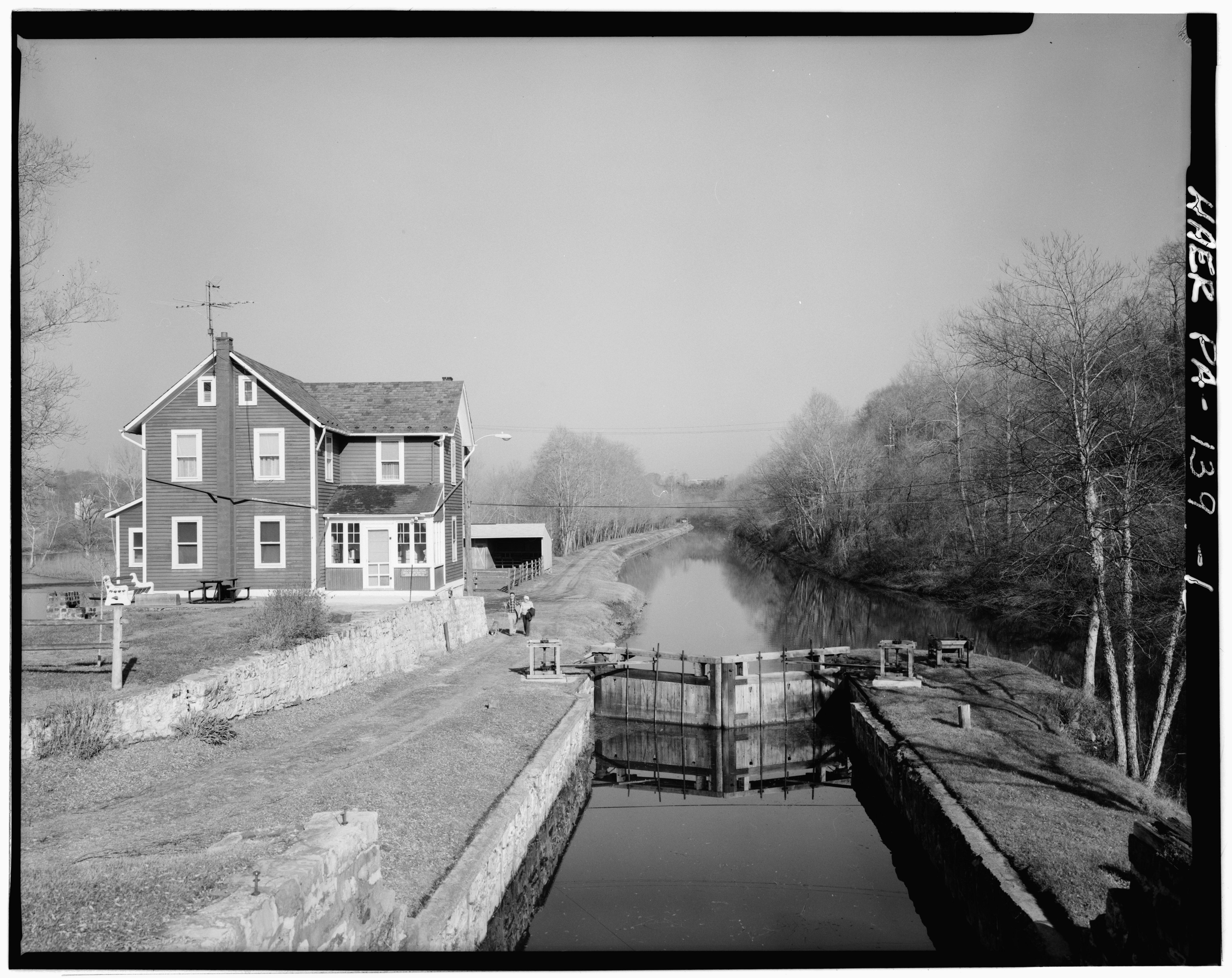
40°40′32″N 75°50′47″W / 40.67556°N 75.84639°WLynn Township 31 Lehigh Canal 
August 15, 1980 Walnutport to Allentown Section
40°42′8″N 75°31′52″W / 40.70222°N 75.53111°WAllentown Extends into Northampton County 32 Lehigh Canal; Allentown to Hopeville Section 
December 17, 1979 Along the Lehigh River
40°36′55″N 75°24′52″W / 40.61528°N 75.41444°WAllentown 33 Linden Grove Pavilion November 30, 1979 Linden and South Main Streets
40°30′18″N 75°23′35″W / 40.505°N 75.39306°WCoopersburg 34 Lock Ridge Furnace Complex September 11, 1981 Franklin and Church Streets
40°30′32″N 75°35′39″W / 40.50889°N 75.59417°WAlburtis 35 Manasses Guth Covered Bridge December 1, 1980 West of Greenawalds on Township 602
40°37′42″N 75°33′13″W / 40.62833°N 75.55361°WSouth Whitehall Township 36 Martin Tower June 28, 2010 1170 8th Ave.
40°37′54″N 75°23′40″W / 40.63167°N 75.39444°WBethlehem 37 Albertus L. Meyers Bridge 
June 22, 1988 8th Street over Little Lehigh and Railroad Streets
40°35′45″N 75°28′16″W / 40.59583°N 75.47111°WAllentown 38 Mount Airy Historic District May 9, 1988 Roughly Prospect Avenue between 15th and 8th Avenues
40°37′12″N 75°24′9″W / 40.62°N 75.4025°WBethlehem 39 Neuweiler Brewery 
June 27, 1980 401 North Front Street
40°36′40″N 75°27′29″W / 40.61111°N 75.45806°WAllentown 40 Old Lehigh County Courthouse 
September 11, 1981 5th and Hamilton Streets
40°36′13″N 75°28′4″W / 40.60361°N 75.46778°WAllentown 41 Rex Covered Bridge December 1, 1980 South of Schencksville on Township 593
40°38′5″N 75°36′47″W / 40.63472°N 75.61306°WNorth Whitehall Township 42 Rodale Organic Gardening Experimental Farm May 12, 1999 2056 Minesite Road
40°33′17″N 75°31′20″W / 40.55472°N 75.52222°WLower Macungie Township 43 Schlicher Covered Bridge December 1, 1980 Legislative Route 39058 near Allentown
40°39′42″N 75°37′38″W / 40.66167°N 75.62722°WNorth Whitehall Township 44 George F. Schlicher Hotel May 7, 1992 105–107 South Main Street
40°30′43″N 75°36′12″W / 40.51194°N 75.60333°WAlburtis 45 Shelter House February 17, 1978 South 4th Street
40°31′50″N 75°29′6″W / 40.53056°N 75.485°WEmmaus 46 Slatington Historic District August 11, 2004 Roughly bounded by Ridge Alley, Chesnut Street, Railroad Street, Kern Street, Hill Alley, 5th Street, and Dowell
40°44′54″N 75°36′43″W / 40.74833°N 75.61194°WSlatington 47 George Taylor House 
July 17, 1971 Front Street
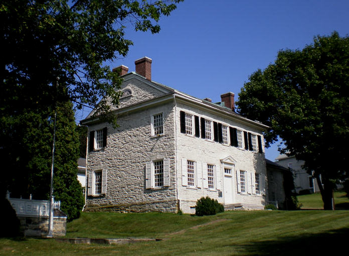
40°38′52″N 75°27′59″W / 40.64778°N 75.46639°WCatasauqua 48 Trout Hall 
November 14, 1978 414 Walnut Street
40°36′9″N 75°27′50″W / 40.6025°N 75.46389°WAllentown 49 Troxell-Steckel House 
June 27, 1980 4229 Reliance Street
40°40′32″N 75°32′8″W / 40.67556°N 75.53556°WEgypt 50 Vigilant Fire Company Firemen's Monument August 11, 2004 Union Cemetery, west side of Pennsylvania Route 873, approximately 1⁄3 miles (0.5 km) south of Slatington
40°44′23″N 75°36′49″W / 40.73972°N 75.61361°WWashington Township 51 Valentine Weaver House June 28, 1984 146 South Church Street
40°30′40″N 75°33′21″W / 40.51111°N 75.55583°WMacungie 52 Wehr Covered Bridge December 1, 1980 West of Greenawald on Township 597
40°34′8″N 75°30′17″W / 40.56889°N 75.50472°WSouth Whitehall Township 53 Zollinger-Harned Company Building 
December 17, 1979 605–613 Hamilton Mall and 14016 North 6th Street
40°36′10″N 75°28′14″W / 40.60278°N 75.47056°WAllentown Former listings
[3] Landmark name[4] Image Date delisted Location City or Town Summary 1 Bridge in Lynn Township 
March 21, 2003 Legislative Route 39112 over Ontelaunee Creek Steinsville See also
- List of National Historic Landmarks in Pennsylvania
- National Register of Historic Places listings in Pennsylvania
- List of Pennsylvania state historical markers in Lehigh County
References
- ^ The latitude and longitude information provided in this table was derived originally from the National Register Information System, which has been found to be fairly accurate for about 99% of listings. For about 1% of NRIS original coordinates, experience has shown that one or both coordinates are typos or otherwise extremely far off; some corrections may have been made. A more subtle problem causes many locations to be off by up to 150 yards, depending on location in the country: most NRIS coordinates were derived from tracing out latitude and longitudes off of USGS topographical quadrant maps created under the North American Datum of 1927, which differs from the current, highly accurate WGS84 GPS system used by Google maps. Chicago is about right, but NRIS longitudes in Washington are higher by about 4.5 seconds, and are lower by about 2.0 seconds in Maine. Latitudes differ by about 1.0 second in Florida. Some locations in this table may have been corrected to current GPS standards.
- ^ "National Register of Historic Places: Weekly List Actions". National Park Service, United States Department of the Interior. Retrieved on November 10, 2011.
- ^ a b Numbers represent an ordering by significant words. Various colorings, defined here, differentiate National Historic Landmark sites and National Register of Historic Places Districts from other NRHP buildings, structures, sites or objects.
- ^ a b "NPS Focus". National Register of Historic Places. National Park Service. http://nrhp.focus.nps.gov. Retrieved November 20, 2009.
Municipalities and communities of Lehigh County, Pennsylvania Cities 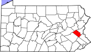
Boroughs Alburtis | Catasauqua | Coopersburg | Coplay | Emmaus | Fountain Hill | Macungie | Slatington
Townships Hanover | Heidelberg | Lower Macungie | Lower Milford | Lowhill | Lynn | North Whitehall | Salisbury | South Whitehall | Upper Macungie | Upper Milford | Upper Saucon | Washington | Weisenberg | Whitehall
CDPs Unincorporated
communitiesBreinigsville | Cementon | Center Valley | Cetronia | Colesville‡ | Dorneyville | East Texas | Egypt | Fogelsville | Hensingersville‡ | Hosensack | Ironton | Kuhnsville | Lanark | Laurys Station | Lehigh Gap‡ | Limeport | Lynnport | Neffs | New Tripoli | New Smithville | Newtown | Old Zionsville | Orefield | Pleasant Corners | Powder Valley | Schoenersville‡ | Shimerville | Slatedale | Summit Lawn | Trexlertown | Vera Cruz | Wescosville | West Catasauqua | Zionsville
Footnotes ‡This populated place also has portions in an adjacent county or counties
Categories:- Lehigh County, Pennsylvania
- National Register of Historic Places in Pennsylvania by county
-


Wikimedia Foundation. 2010.