- U.S. Route 19
Infobox U.S. Route
article_route=19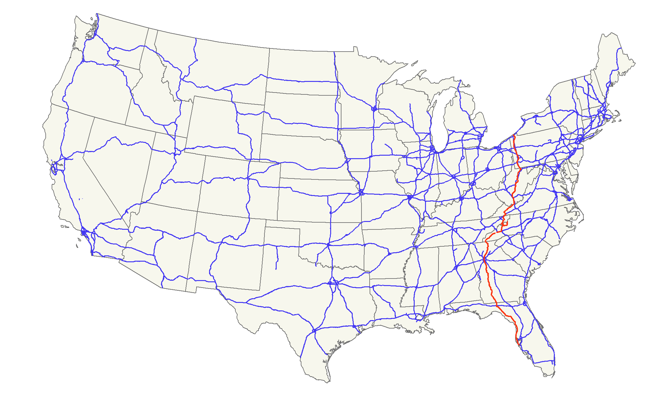
length_mi=1,406
length_ref= [http://www.us-highways.com/us1830.htm US Highways from US 1 to US 830] Robert V. Droz]
length_km=2,262
yrcom=1926
direction_a=South
direction_b=North
from=jct|state=FL|US|41 nearBradenton, FL
junction= jct|state=FL|I|10 nearMonticello, FL
Jct|state=GA|I|20|I|75|I|85 inAtlanta, GA
Jct|state=NC|I|26|I|40 inAsheville, NC
jct|state=VA|I|81 inBristol, VA
Jct|state=WV|I|64|I|77 nearBeckley, WV
Jct|state=WV|I|79 "(numerous locations)"
jct|state=PA|I|70 inWashington, PA
jct|state=PA|I|76 inWarrendale, PA
jct|state=PA|I|80 nearMercer, PA
jct|state=PA|I|90 nearErie, PA
to=jct|state=PA|US|20 inErie, PA U.S. Route 19 is a north-south
U.S. Highway . Despite encroachingInterstate Highway s, the route has remained a long-haul route, connectingLake Erie with theGulf of Mexico .The highway's northern terminus is in
Erie, Pennsylvania , at an intersection withU.S. Route 20 about a mile from the shores ofLake Erie . Its southern terminus is atMemphis, Florida , just north ofBradenton ,Florida at an intersection withU.S. Route 41 . [http://www.geocities.com/usend1019/End019/end019.htm Endpoints of US highways] ]Route description
Florida
According to a "
Dateline NBC " study, part of US 19 inFlorida is the most dangerous road in theUnited States . AFlorida Highway Patrol test period beginning in1998 and ending in2003 , as mandated by theNational Highway Traffic Safety Administration , showed the stretch of US 19 from Pasco County to Pinellas County to average approximately 52 deaths a year, or 262 deaths in the 5 year duration of the study. 100 of these deaths were pedestrian related making US 19 the #1 worst road to walk on in these two counties.cite web | url=http://msnbc.msn.com/id/7844269/|title=MSNBC report on America's deadliest roads | publisher=MSNBC | accessdate=2007-04-21 | date=June 7, 2005] Multiple efforts to improve US 19 have been suggested to the FDOT, among them, an overpass strictly for left-turn lanes. [ [Suncoast News; Taking the High Road by Carl Orth; August 4, 2001] ]US 19 remains independent of I-75, even as the routes converge on Tampa and
St. Petersburg, Florida . The route is co-signed with US 27 between Capps and Perry, Alternate US 27 between Perry and Chiefland, US 98 between Perry and Chassahowitzka, and Interstate 275 over theSunshine Skyway Bridge , acable-stayed bridge over the mouth ofTampa Bay .US 19 also has a bannered alternate route which is located on the original path of US 19. It begins in Holiday approximately one mile north of the Pinellas County line, enters the county in Tarpon Springs, runs along the
Intracoastal Waterway through Dunedin, Clearwater, and Largo, heads due south into Seminole, and turns east to meet up with its parent in St. Petersburg. State Road 595 also follows this path, but extends past US 19 into downtown St. Petersburg.US Alt 19 has been permanently rerouted as of the week of
January 27 ,2007 in Clearwater and Largo. When approaching from Dunedin, Alt 19 now travels down Myrtle St instead of continuing down Ft. Harrison and overlaps SR 60 on Court/Chestnut St. and heads East to Missouri Ave. Alt. US 19 and SR 60 overlap from Myrtle Ave to Missouri Ave. Alt 19 then travels down Missouri Ave to Largo to meet at W.Bay/E. Bay Drive to meet its former configuration. Currently, signage has been reflected to this change from north to south but the city of Largo has not updated the changed path of Alt. 19 as of February 2007. New mileage will have to be slightly recalcuated to reflect the new mileage of US Alt 19 in Pinellas County.The secret designation for US 19 in Florida, beteween Perry and Memphis, is State Road 55. Between Perry and Capps, it follows State Road 20, and between Capps and the Georgia border, it follows State Road 57.
Currently, US 19 between Clearwater and Pinellas Park is getting a freeway-style upgrade ( [http://www.southeastroads.com/us-019_fl.html] [http://www.myus19.com] ), due to the cancellation of an extension of Interstate 375 in the late 1970s.
Major intersections
Georgia
US 19 pursues an independent path in Georgia, with
Interstate 75 as much as 50 miles (80 km) away. It is concurrent withU.S. Route 41 in downtown Atlanta continuing south throughClayton County, GA where it joinsGeorgia State Route 3 and is known asTara Boulevard through the western tip ofHenry County, GA andHampton, GA passingAtlanta Motor Speedway where it is known asBear Creek Boulevard and splitting away from US 41 InGriffin, GA . It continues its southern route passing through Albany before exiting Georgia from Thomas County. Between downtown Atlanta and I-285, it overlaps State Route 9 (Roswell Road). BetweenInterstate 285 andDahlonega, Georgia , it has a concurrency with State Route 400.North Carolina
The split routes join together and are co-signed or closely parallel
Interstate 26 andInterstate 40 until I-40 veers north, leaving US 19 to head into theGreat Smoky Mountains as theGreat Smoky Mountains Expressway . US 19 passes through the Eastern Cherokee Indian Reservation.Tennessee
As of
2004 , US 19 splits into US 19E and US 19W inBluff City, Tennessee . The routes rejoin in ruralYancey County, North Carolina . While US 19W heads directly forInterstate 26 inJohnson City, Tennessee , US 19E takes a 70-mile (113 km) path through theGreat Smoky Mountains . US 19W doesn't completely avoid the mountains, however. It breaks off of I-26 shortly before theTennessee -North Carolina border, and takes a tortuous path through the mountains of Yancey County, North Carolina.US 19 breaks away from the interstate, but alternate route US 19W is co-signed with
Interstate 26 for much of its Tennessee length. US 19E in Tennessee is the same highway as State Route 37.Virginia
It is paralleled by
Interstate 81 , 10-20 miles (16-32 km) distant across a mountain ridge.West Virginia
US 19 enters
West Virginia as a four lane highway near Bluefield, where it narrows to a two-lane as it winds northward. It later parallelsInterstate 77 and 64 until it reaches Beckley, where it becomes the four-laneCorridor L . It crosses theNew River Gorge Bridge at Fayetteville and passes through Summersville, and Birch River before arriving atInterstate 79 , five miles (8 km) south of Sutton. From there, it runs concurrent withInterstate 79 from exit 57 to exit 67 atFlatwoods, West Virginia . Then, it exits and reverts a two lane highway, more or less following the route ofInterstate 79 as it passes through Weston, Clarksburg, Fairmont, and Morgantown before crossing intoPennsylvania .Route 19 through
Summersville, West Virginia has been dubbed the "World's Largest Speed Trap." [cite news|url=http://www.post-gazette.com/pg/05324/608879.stm|title=Speed trap or safety measure? Summersville, W. Va., police wrote 10,000 tickets in 2004|work=Pittsburgh Post-Gazette |author=Anya Sostek|date=2005-11-20 |accessdate=2008-01-10]Pennsylvania
It is closely paralleled by
Interstate 79 for its entire length. Its northern terminus runs through the city of Erie crossing its downtown and suburban areas before heading towardsInterstate 79 . It runs close to the heart ofPittsburgh and traverses theWest End Bridge with a great view of Downtown Pittsburgh'sGolden Triangle ,Point State Park , andHeinz Field .In northern Washington County, U.S. Route 19 was modernized after the trolley service operated the former Pittsburgh Railways Company (PRCo) was discontinued in August 1953. Initially Route 19 ran parallel to the trolley line, and later expanded over the tracks through part of Mt. Lebanon in souther Allegheny County.
U.S. 19 then proceeds north through Pittsburgh's Northside,
West View , Perrysville and Ross Township, McCandless Township and Wexford, where it is referred to as Perry Highway. In Cranberry Township, it connects with I-79, thePennsylvania Turnpike , and PA 228. A popular destination along the route isBaldinger's Market outside Zelienople. Continuing through Mercer and Crawford counties, the route terminates in the city of Erie.A Truck 19 designation exists in
Pittsburgh , running fromWexford, Pennsylvania toMt. Lebanon, Pennsylvania . Interestingly enough, while both of that route's termini are with the regular U.S. 19, the two routes actually intersect near theFort Pitt Tunnel on Pittsburgh's West End.History
Prior to US Highway Numbering System, US 19 was
West Virginia Route 4 .The planned St. Petersburg-Clearwater Expressway, or Pinellas Beltway, would have followed the current alignment of "Alt 19" from I-275 to
Clearwater, Florida . The intersection of Seminole Boulevard and Bay Pines Boulevard is a remnant of this proposed road. The beltway road was proposed in 1974, but dead by 1980. [http://www.southeastroads.com/us-019_fl.html Pinellas Beltway/St. Petersburg Clearwater Expressway reference] ]See also
*
List of U.S. Routes Related U.S. Routes
*
U.S. Route 119
*U.S. Route 219
*U.S. Route 319 Bannered and suffexed routes
*
U.S. Route 19E
*U.S. Route 19W
*U.S. Route 19 Business inDahlonega, Georgia
*U.S. Route 19 Truck inPittsburgh, Pennsylvania References
pa browse|previous_type=PA|previous_route=18|route=PA
next_type=US|next_route=20
###@@@KEYEND@@@###
Wikimedia Foundation. 2010.