- Thomas County, Georgia
Infobox U.S. County
county = Thomas County
state = Georgia
seallink =
map size = 225
founded year = 1825
founded date = December 24
seat = Thomasville
largest city = Thomasville
area_total_sq_mi = 552
area_total_km2 = 1430
area_land_sq_mi = 548
area_land_km2 = 1420
area_water_sq_mi = 4
area_water_km2 = 10
area percentage =
census yr = 2000
pop = 42737
density_sq_mi = 78
density_km2 = 30
time zone = Eastern
UTC offset = -5
DST offset = -4
footnotes =
web = http://www.thomascountyboc.org/
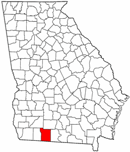
named for =Jett Thomas |Thomas County is a
county located in theU.S. state of Georgia. As of 2000, the population was 42,737. The county's growth is evident with a population of 45,237 according to the 2007 U.S. Census Estimate [http://www.census.gov/popest/counties/tables/CO-EST2007-01-13.xls] . Thecounty seat is Thomasville, GeorgiaGR|6.History
Thomas County was created by an act of the
Georgia General Assembly onDecember 24 ,1825 , from portions of Decatur and Irwin counties. Colquitt (1856), Brooks (1858), and Grady (1905) Counties all were formed partially from lands within Thomas County's original borders.The County is named for
Jett Thomas , officer in theWar of 1812 who is also known for overseeing the construction of the first building at theUniversity of Georgia (originally referred to as Franklin College and known today as Old College) as well as the state capitol at Milledgeville.Geography
According to the
U.S. Census Bureau , the county has a total area of 552square mile s (1,430km² ), of which, 548 square miles (1,420 km²) of it is land and 4 square miles (10 km²) of it (0.68%) is water.Major highways
*
*
*
*
*
*Adjacent counties
*Colquitt County, Georgia - northeast
*Brooks County, Georgia - east
*Jefferson County,Florida - south
*Leon County,Florida - southwest
*Grady County, Georgia - west
*Mitchell County, Georgia - northwestDemographics
As of the
census GR|2 of 2000, there were 42,737 people, 16,309 households, and 11,465 families residing in the county. Thepopulation density was 78 people per square mile (30/km²). There were 18,285 housing units at an average density of 33 per square mile (13/km²). The racial makeup of the county was 58.98% White, 38.86% Black or African American, 0.29% Native American, 0.41% Asian, 0.06% Pacific Islander, 0.54% from other races, and 0.85% from two or more races. 1.72% of the population were Hispanic or Latino of any race.There were 16,309 households out of which 32.70% had children under the age of 18 living with them, 47.90% were married couples living together, 18.40% had a female householder with no husband present, and 29.70% were non-families. 25.80% of all households were made up of individuals and 10.60% had someone living alone who was 65 years of age or older. The average household size was 2.55 and the average family size was 3.06.
In the county the population was spread out with 27.10% under the age of 18, 8.10% from 18 to 24, 28.20% from 25 to 44, 22.90% from 45 to 64, and 13.70% who were 65 years of age or older. The median age was 36 years. For every 100 females there were 88.90 males. For every 100 females age 18 and over, there were 84.80 males.
The median income for a household in the county was $31,115, and the median income for a family was $39,239. Males had a median income of $28,395 versus $21,344 for females. The
per capita income for the county was $16,211. About 13.60% of families and 17.40% of the population were below thepoverty line , including 21.90% of those under age 18 and 19.30% of those age 65 or over.Cities and towns
*Barwick
*Boston
*Coolidge
*Meigs
*Ochlocknee
*Pavo
*ThomasvilleUnincorporated cities
Education
*
Thomas University
*Southwest Georgia Technical College External links
* [http://www.thomascountyboc.org/ Thomas County's Website]
* [http://www.thomascountyextension.com/ University of Georgia Thomas County Cooperative Extension Website]
* [http://www.thomasvillelandmarks.org/ Thomasville Landmarks - Historic preservation organization]References
* [http://www.dca.state.ga.us/snapshots/PDF/Thomas.pdf Georgia Snapshots - Thomas County]
* [http://www.cviog.uga.edu/Projects/gainfo/courthouses/thomasCH.htm GeorgiaInfo Thomas County Courthouse history]
* [http://www.athensclarkecounty.com/~planningdept/document/DowntownDesigRepFINAL.pdf "Local Historic Property Designation Report", Historic Preservation Commission, Planning Department, Unified Government of Athens-Clarke County, Georgia, p,47]
Wikimedia Foundation. 2010.