- Pennsylvania Route 58
-
PA Route 58
Route information Maintained by PennDOT Length: 71.2 mi[1] (115 km) Existed: 1927 – present Major junctions West end:  SR 5 near Jamestown
East end:  PA 68 in Sligo
Location Counties: Mercer, Butler, Armstrong, Clarion Highway system Roads in Pennsylvania
Interstate • US • State • Legislative←  PA 56
PA 56PA 59  →
→Pennsylvania Route 58 is located in Western Pennsylvania, running 71.2 miles from the Ohio state line 3 miles (4.8 km) west of Jamestown in Mercer County to Sligo in Clarion County.
Contents
Route description
Mercer County
Route 58 travels eastward from the Ohio state line in northwestern Mercer County just over 4 miles (6.4 km) to the borough of Jamestown, where it intersects with US 322. The two routes join together and continue eastward nearly 0.3 miles (0.48 km) where US 322 leaves northward. Route 58 continues eastward, then turns southeasterly, and about 6 miles (9.7 km) later, joins PA Route 18 just north of the Greenville borough line. The concurrency continues 0.4 miles (0.64 km) into the borough to its junction with PA Route 358. The three routes form a concurrency and head westward – this segment is what is known as a “reverse concurrency,” because Route 58 is signed east at the same time that Route 358 is signed west. The concurrency lasts only a quarter mile, and then Route 58 leaves the concurrency, heading south-southeast nearly 15 miles (24 km) to the borough of Mercer. Here, the route first meets the US 19/US 62 concurrency. The three routes form a concurrency south 0.2 miles (0.32 km) to the intersection of PA Route 258. At this complex intersection, the concurrency ends, US 62 continues westward, concurrent with Route 258, US 19 continues south, and Routes 58 and 258 join to the east. Also at this point, the Route 58/Route 258 concurrency is split – eastbound follows S. Diamond St., and westbound follows N. Diamond St. in the middle of town. At the east end of the “square,” the concurrency ends as Route 258 heads southward and Route 58 continues east, then later turns southeast. It crosses both I-80 and I-79 near the interchange of the two interstates, just over 4 miles (6.4 km) from Mercer, and enters the borough of Grove City about 4.5 miles (7.2 km) later. In Grove City, the route intersects with the southern terminus of the PA Route 173/PA Route 208 concurrency, and overlaps with Route 173, continuing southeast. About 0.3 miles (0.48 km) later, the concurrency ends; Route 173 continues south, and Route 58 continues southeast just over 3 miles (4.8 km) to the Butler county line after spending 39 miles in Mercer County.
Butler County
A mile after entering Butler County, Route 58 intersects with PA Route 8 in the borough of Harrisville. The route then travels nearly 7 miles (11 km) to intersect with PA Route 308. The next major intersection is about 4.6 miles (7.4 km) later at PA Route 38 in the borough of Eau Claire. The route then travels nearly 6 miles (9.7 km) before crossing the next county line. The road spends about 18.5 miles in Butler County.
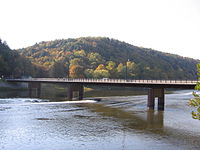 The Foxburg Bridge carries Route 58 over the Allegheny River between Armstrong and Clarion County.
Armstrong County
Route 58 has a very short stay in Armstrong County, passing through its extreme northwestern tip. Just 0.4 miles (0.64 km) from the county line, the route intersects with PA Route 268, it then crosses Allegheny River on the Foxburg Bridge, leaving the county just about 0.2 miles (0.32 km) later.
Clarion County
Turning northeasterly, the route passes through the borough of Foxburg upon entering Clarion County, and then heads northeast to enter the borough of St. Petersburg a little over 2 miles (3.2 km) later. Here, Route 58 intersects with the southern terminus of PA Route 478, and then about 1.9 miles (3.1 km) later, it intersects with the southern terminus of PA Route 338 at the village of Alum Rock. The route then winds southeastward 5.3 miles (8.5 km) to intersect with the eastern terminus of PA Route 368 just east of the borough of Callensburg. Route 58 then travels east-southeast nearly 3.5 miles (5.6 km) to its terminus at PA Route 68 in the borough of Sligo The road spends 13 miles in Clarion County.
Major intersections
County Location Mile Destinations Notes Mercer Greene Township 0.0 SR 5 (Street Road)Continuation into Ohio Jamestown 4.4  US 322 west (Gibson Street)
West end of US 322 concurrency 4.7 US 322 east (Depot Street)East end of US 322 concurrency Hempfield Township 10.8  PA 18 north (Packard Avenue)
West end of PA 18 concurrency Greenville 11.2  PA 358 east (Main Street)
West end of PA 358 concurrency 11.5 PA 18 south / PA 358 west (Main Street)East end of PA 18/358 concurrencies Mercer 26.1 
 US 19 north / US 62 north (Franklin Street)
West end of US 19/62 concurrencies 26.3  US 19 south / US 62 south / PA 258 north (Erie Street)
East end of US 19/62 concurrencies,
West end of PA 258 concurrency26.5 PA 258 south (Pitt Street)East end of PA 258 concurrency Grove City 35.7 
 PA 173 north / PA 208 (Center Street)
West end of PA 173 concurrency 36.0 PA 173 north (Liberty Street)East end of PA 173 concurrency Butler Harrisville 40.2  PA 8 (Main Street)
Marion Township 47.0  PA 308 (Sunbury Road)
Eau Claire 51.6  PA 38 (Washington Street)
Armstrong Hovey Township 58.0  PA 268
Clarion St. Petersburg 60.5  PA 478 (Salem Avenue)
Southern terminus of PA 478 Richland Township 62.4  PA 338
Southern terminus of PA 338 Licking Township 67.7  PA 368 (Main Street)
Eastern terminus of PA 368 Sligo 71.2 PA 68 (Front Street, Colleran Street)1.000 mi = 1.609 km; 1.000 km = 0.621 mi Attractions
History
- 1927 – Originally signed from New Wilmington to Greenville on the current PA 18 alignment.[2]
- 1928 – Moved to the Mercer-to-Greenville alignment.[2]
- 1946 – Western terminus moved from Jamestown to the Ohio state line.[2]
- 1967 – Eastern terminus moved from PA 8 in Harrisville to its current location.[2]
See also
Spur routes
- Pennsylvania Route 158, from south of New Wilmington to Mercer (does not intersect with parent route)
- Pennsylvania Route 258, from Clark to Slippery Rock
- Pennsylvania Route 358, from west of Greenville to Sandy Lake
References
External links
Categories:- State highways in Pennsylvania

Wikimedia Foundation. 2010.