- Maurice K. Goddard State Park
-
Maurice K. Goddard State Park Pennsylvania State Park Natural Monument (IUCN III) 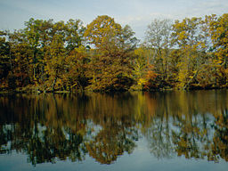 Fall foliage reflected in Lake Wilhelm in the park
Country United States State Pennsylvania County Mercer Townships Deer Creek, Mill Creek, New Vernon, Sandy Lake Location [1] - coordinates 41°25′44″N 80°08′41″W / 41.42889°N 80.14472°WCoordinates: 41°25′44″N 80°08′41″W / 41.42889°N 80.14472°W - elevation 1,270 ft (387 m) [1] Area 2,856 acres (1,156 ha) Founded 1972 Managed by Pennsylvania Department of Conservation and Natural Resources Visitation over 200,000 (in 2008) [2] 
 Location of Maurice K. Goddard State Park in Pennsylvania
Website : Maurice K. Goddard State Park Maurice K. Goddard State Park is a 2,856-acre (1,156 ha) Pennsylvania state park in Deer Creek, Mill Creek, New Vernon and Sandy Lake Townships, Mercer County, Pennsylvania in the United States. It features natural beauty, wildlife, waterways and public recreational facilities. Lake Wilhelm shares its shorelines with Maurice K. Goddard State Park and State Game Land No. 270. The dam, constructed in 1971, creates a 1,860-acre (750 ha) lake providing a resource for people and wildlife. Many species of fish and amphibians make Lake Wilhelm their home. A variety of outdoor activities are available in and around the Park vicinity. The addition of the Goddard Classroom, at the Marina facility, provides the opportunity to present programs about nature, wildlife and ecology. Special events and programs are held throughout the summer months. Maurice K. Goddard State Park is just off exit 130 of Interstate 79 on Pennsylvania Route 358.
Contents
History
Sandy Creek, the stream that was dammed to create Lake Wilhelm, was noted in reports made by George Washington during his 1753 trip to Fort LeBoeuf during the French and Indian War. Sandy Creek had a recurring history of flooding. This led to a study by the U.S. Army Corps of Engineers. The study began in 1939. Plans were delayed by the start of World War II but the citizens of Mercer County could see the benefit of building a flood control dam on Sandy Creek. The state, county, township and municipal authorities of the surrounding area worked together to push forward the idea of building the dam and recreational facilities in Mercer County. The land was acquired in the late 1960s. Construction on the dam began soon after and was completed in 1971. Maurice K. Goddard State Park was opened to the public in 1972.[3]
Maurice K. Goddard State park is named for Maurice K. Goddard. Goddard was a graduate of the University of Maine and the University of California at Berkeley. After reaching the rank of Lieutenant Colonel during World War II, Goddard came to Pennsylvania where he took a job at Mont Alto Forestry School and later at Penn State Main Campus before he was appointed Secretary of the Pennsylvania Bureau of Forests and Waters, a forerunner of the Pennsylvania Department of Conservation and Natural Resources. Upon taking his position with the state, Goddard set about completing his goal of having a state park within 25 miles (40 km) of every resident of Pennsylvania. When Goddard retired in 1979, after 24 years working for the state parks, he had helped to add 45 state parks and over 130,000 acres (52,600 ha) of state park land to the Pennsylvania State Park system.[4]
Recreation
Bird watching
A wide variety of habitats at Maurice K. Goddard State Park attracts a wide variety of birds. Bald Eagles and osprey can be seen flying over Lake Wilhelm as they scan the waters for fish. The old fields and forests are home to woodcocks, nighthawks, snipes, and a variety of warblers. Migrating waterfowl like the loon, common teal, goldeneye, merganser, and bufflehead stop by Lake Wilhelm in the spring and fall. Woodpeckers including the Pileated Woodpecker live in the woods of the park. Bluebirds and purple martins make their homes in the old fields and meadows of Maurice K. Goddard State Park.[4][5]
Lake Wilhelm
Lake Wilhelm is a warm water fishery it lies partly within Maurice K. Goddard State Park and partly within the adjoining game lands. The common game fish found in the lake are largemouth and smallmouth bass, perch, crappie, bluegill, catfish, walleye, northern pike and muskellunge. All fishermen are expected to follow the rules and regulations of the Pennsylvania Fish and Boat Commission.[4] Five natural gas wells have been drilled around Lake Wilhelm as of May 2009, with up to 15 more to follow. The state does not own the mineral rights under much of the park, but did work with the driller to minimize the impact of the wells on recreational uses of the park.[2]
The portions of Lake Wilhelm that are within Maurice K. Goddard State Park are open to watercraft up to 20 horsepower (15 kW). There is a 241 space marina and a 48 space dry land mooring area that is open from May 1 to October 31. The marina has an ample parking lot for cars and trucks with trailers. There are four boat launches, a marina building and a fueling station. Rowboats, peddle boats, canoes and kayaks are available to rent. Only non-powered boats are permitted in the portions of the lake that are within the state game land boundaries. All vessels must have a current registration from any state or a launch permit from the Pennsylvania Fish and Boat Commission.[4]
Hunting
There are over 1,155 acres (467 ha) that open to hunting at Maurice K. Goddard State Park. Hunters are expected to follow the rules and regulations of the Pennsylvania Game Commission. The common game species are waterfowl and White-tailed Deer. The hunting of Groundhogs is prohibited. Hunters may gain access to the nearby state game lands by entering through the park.[4]
Winter activities
Maurice K. Goddard State Park is open during the winter months for ice fishing, ice boating, ice skating, sledding and tobogganing, cross-country skiing and snowmobiling.[4]
Friends Of Goddard
The Friends of Goddard State Park partner with Goddard State Park to help conserve the natural beauty of the areas within and around Goddard State Park by educating and introducing people to the immense world of nature and the facilities available to them.[4]
Friends of Goddard State Park also known as "FroG" is a sub-chapter of the Pennsylvania Parks and Forest Foundation and a non-profit 501(3)c organization.[4]
Nearby state parks
The following state parks are within 30 miles (48 km) of Maurice K. Goddard State Park:[6][7][8][9]
- Jennings Environmental Education Center (Butler County)
- Oil Creek State Park (Venango County)
- Pymatuning State Park (Pennsylvania) (Crawford County)
- Pymatuning State Park (Ohio) (Ashtabula County)
References
- ^ a b "Maurice K. Goddard State Park". Geographic Names Information System. United States Geological Survey. August 30, 1990. http://geonames.usgs.gov/pls/gnispublic/f?p=gnispq:3:::NO::P3_FID:1198260. Retrieved 2008-06-11.
- ^ a b Hopey, Don (May 3, 2009). "Goddard State Park's gas wells may be first of hundreds: Where mineral rights are privately owned, Pennsylvania officials can't prevent drilling". Pittsburgh Post-Gazette. http://www.post-gazette.com/pg/09123/967360-113.stm. Retrieved May 6, 2009.
- ^ "Maurice K. Goddard State Park - History". Pennsylvania Department of Conservation and Natural Resources. Archived from the original on 2006-08-28. http://web.archive.org/web/20060828233442/http://www.dcnr.state.pa.us/stateparks/parks/mauricekgoddard_history.aspx. Retrieved 2007-01-16.
- ^ a b c d e f g h "Maurice K. Goddard State Park". Pennsylvania Department of Conservation and Natural Resources. http://www.dcnr.state.pa.us/stateparks/parks/mauricekgoddard.aspx. Retrieved 2007-01-16.
- ^ "Maurice K. Goddard State Park - Wildlife". Pennsylvania Department of Conservation and Natural Resources. Archived from the original on 2007-02-12. http://web.archive.org/web/20070212213307/http://www.dcnr.state.pa.us/stateparks/parks/mauricekgoddard_wildlife.aspx. Retrieved 2007-01-16.
- ^ "Find a Park by Region (interactive map)". Pennsylvania Department of Conservation and Natural Resources. http://www.dcnr.state.pa.us/stateparks/findapark/where/index.htm. Retrieved November 18, 2011.
- ^ Michels, Chris (1997). "Latitude/Longitude Distance Calculation". Northern Arizona University. http://www2.nau.edu/~cvm/latlongdist.html. Retrieved 2008-04-23.
- ^ Pennsylvania Department of Transportation, Bureau of Planning and Research, Geographic Information Division (PDF). "2007 General Highway Map Mercer County Pennsylvania" (Map). 1:65,000. ftp://ftp.dot.state.pa.us/public/pdf/BPR_pdf_files/Maps/GHS/Roadnames/mercer_GHSN.PDF. Retrieved 2007-07-28. Note: shows Maurice K. Goddard State Park
- ^ "Find a Park PA Great Lakes Region". Pennsylvania Department of Conservation and Natural Resources. http://www.dcnr.state.pa.us/stateparks/parks/region_greatlakes.aspx. Retrieved 2007-01-16.
External links
- Maurice K. Goddard State Park Official mapPDF (903 KB)
- Goddard State Park's gas wells may be first of hundreds
- Friends of Goddard website
Categories:- Pennsylvania state parks
- Protected areas established in 1972
- Parks in Mercer County, Pennsylvania


Wikimedia Foundation. 2010.