- Colonel Denning State Park
-
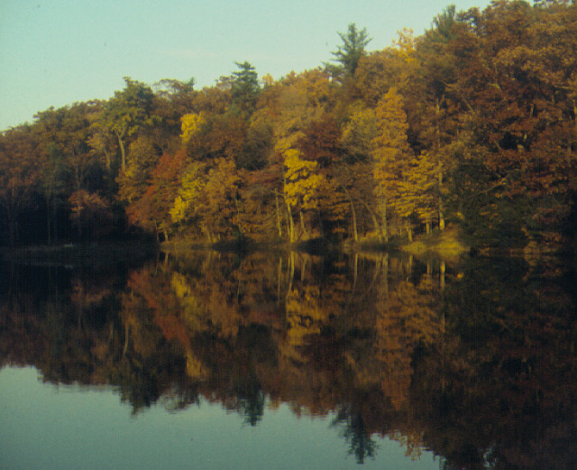
Colonel Denning State Park Pennsylvania State Park Natural Monument (IUCN III)  Doubling Gap Lake
Named for: William Denning Country United States State Pennsylvania County Cumberland Township Lower Mifflin Location [1] - coordinates 40°16′24″N 77°24′59″W / 40.27333°N 77.41639°WCoordinates: 40°16′24″N 77°24′59″W / 40.27333°N 77.41639°W - elevation 1,132 ft (345 m) [1] Area 273 acres (110 ha) [2] Founded 1936 [2] Managed by Pennsylvania Department of Conservation and Natural Resources 
 Location of Colonel Denning State Park in Pennsylvania
Website : Colonel Denning State Park Colonel Denning State Park is a 273-acre (110 ha) Pennsylvania state park in Lower Mifflin Township, Cumberland County, Pennsylvania in the United States. The park is in the Doubling Gap of Blue Mountain on Pennsylvania Route 233 between Newville and Landisburg. Doubling Gap Lake is a man-made lake covering 3.5 acres (1.4 ha). Colonel Denning State Park is surrounded by Tuscarora State Forest.
Contents
History
Colonel Denning State Park is named in honor of William Denning who was, oddly, never a colonel. He was a veteran of the American Revolutionary War and a manufacturer of wrought iron cannons. Denning was a sergeant in the Continental Army from March 1778 until April 1780. He was stationed near Carlisle at Washingtonburg Forge, now the Carlisle Barracks. While stationed there, Denning explored and mastered the technique of creating lighter and easier to transport cannons. He did this by welding strips of wrought iron together in layers and building the cannon with the layers. Denning lived out his life following the Revolution near Newville. His grave can be found in the cemetery of Big Spring Presbyterian Church in Newville.[2]
Many of the facilities at Colonel Denning State Park were constructed during the Great Depression in the 1930s by the Civilian Conservation Corps. It was formally opened in 1936.[2]
Recreation
Colonel Denning State Park is open to hunting. Hunters are expected to follow the rules and regulations of the Pennsylvania Game Commission. The common game species are squirrels, white-tailed deer, and turkeys. The hunting of groundhogs is prohibited. Hunting is also permitted in the nearby Tuscarora State Forest. Doubling Gap Lake is open for trout fishing during the trout season established by the Pennsylvania Fish and Boat Commission.[2]
There are 18 miles (29 km) of hiking trails at Colonel Denning State Park and the park serves as a trailhead for the Tuscarora Trail (105 miles (169 km)). Visitors are permitted to swim at their own risk in Doubling Gap Lake; lifeguards are not provided. There are over 200 picnic tables available at Colonel Denning State Park.[2]Flat Rock trail is a 4-mile (6.4 km) out-and-back hike reaching a peak elevation of 1,987 feet (606 m) at Flat Rock. At the rock, a cool breeze is welcome to hikers in the summertime. Occasionally, black bears are seen along the trail.
The camping season at Colonel Denning State Park begins with the start of trout season and ends at the conclusion of deer season. There are 52 tent and trailer sites. Each site is equipped with a fire ring and picnic table. Outhouses are available at the campsite.[2] On Flat Rock Trail 1.1 miles (1.8 km) up the mountain, a camping shelter was built as an Eagle Scout project in 2000. A picnic table and fire pit accommodate the shelter along with an outhouse located a few hundred feet away.
Nearby state parks
The following state parks are within 30 miles (48 km) of Colonel Denning State Park:[3][4][5]
- Big Spring State Park (Perry County)
- Caledonia State Park (Adams and Franklin Counties)
- Fowlers Hollow State Park (Perry County)
- Kings Gap Environmental Education and Training Center (Cumberland County)
- Little Buffalo State Park (Perry County)
- Mont Alto State Park (Franklin County)
- Pine Grove Furnace State Park (Cumberland County)
References
- ^ a b "Colonel Denning State Park". Geographic Names Information System. United States Geological Survey. August 30, 1990. http://geonames.usgs.gov/pls/gnispublic/f?p=gnispq:3:::NO::P3_FID:1196527. Retrieved 2008-02-10.
- ^ a b c d e f g "Colonel Denning State Park". Pennsylvania Department of Conservation and Natural Resources. http://www.dcnr.state.pa.us/stateparks/findapark/coloneldenning/index.htm. Retrieved 2006-11-07.
- ^ "Find a Park by Region (interactive map)". Pennsylvania Department of Conservation and Natural Resources. http://www.dcnr.state.pa.us/stateparks/findapark/where/index.htm. Retrieved November 18, 2011.
- ^ Pennsylvania Department of Transportation, Bureau of Planning and Research, Geographic Information Division. 2007 General Highway Map Cumberland County Pennsylvania (Map). 1:65,000. ftp://ftp.dot.state.pa.us/public/pdf/BPR_pdf_files/Maps/GHS/Roadnames/cumberland_GHSN.PDF. Retrieved 2007-07-27. Note: shows Colonel Denning State Park
- ^ Michels, Chris (1997). "Latitude/Longitude Distance Calculation". Northern Arizona University. http://www2.nau.edu/~cvm/latlongdist.html. Retrieved 2008-04-20.
External links
- Colonel Denning State Park official mapPDF (109 KB)
Categories:- Protected areas established in 1936
- Pennsylvania state parks
- Civilian Conservation Corps in Pennsylvania
- Parks in Cumberland County, Pennsylvania

Wikimedia Foundation. 2010.