- Buchanan State Forest
Geobox Protected Area
name = Buchanan State Forest
native_name =
other_name =
other_name1 =
category_local = Pennsylvania State Forest
category_iucn = Managed Resource Protected Area (IUCN VI)
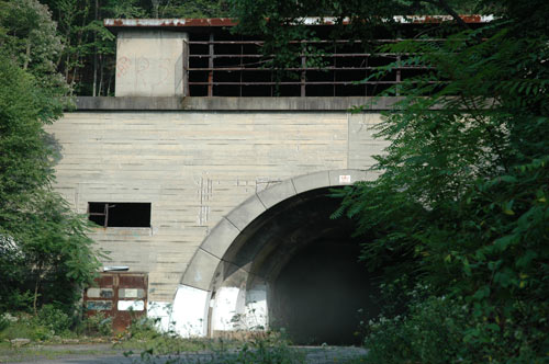
image_caption = Sideling Hill Tunnel is now surrounded by Buchanan State Forest
etymology_type = Named for
etymology =James Buchanan
country = United States
state = Pennsylvania
region_type = Counties
region = Bedford
region1 = Franklin
region2 = Fulton
district_type =
district =
city =
city1 =
location =
lat_d = 39
lat_m = 49
lat_s = 55
lat_NS = N
long_d = 78
long_m = 32
long_s = 54
long_EW = W
elevation_imperial = 2493
elevation_round = 1
area_unit = acre
area_imperial = 75000
area_round = 1
area1_imperial =
area1_type =
length_imperial =
length_orientation =
width_imperial =
width_orientation =
highest =
highest location =
highest_lat_d =
highest_lat_m =
highest_lat_s =
highest_lat_NS =
highest_long_d =
highest_long_m =
highest_long_s =
highest_long_EW =
highest_elevation_imperial =
lowest =
lowest_location =
lowest_lat_d =
lowest_lat_m =
lowest_lat_s =
lowest_lat_NS =
lowest_long_d =
lowest_long_m =
lowest_long_s =
lowest_long_EW =
lowest_elevation_imperial =
biome =
biome_share =
biome1 =
biome1_share =
geology =
geology1 =
plant =
plant1 =
animal =
animal1 =
established_type =
established =
established1_type =
established1 =
management_body = Pennsylvania Department of Conservation and Natural Resources
management_location =
management_lat_d =
management_lat_m =
management_lat_s =
management_lat_NS =
management_long_d =
management_long_m =
management_long_s =
management_long_EW =
management_elevation =
visitation =
visitation_year =
free_type = Nearest city
free =Chambersburg, Pennsylvania
free1_type =
free1 =
map_caption = Buchanan State Forest
map1 = Pennsylvania Locator Map.png
map1_locator = Pennsylvania
map_first =
website = [http://www.dcnr.state.pa.us/forestry/stateforests/Buchanan.aspx Buchanan State Forest]Buchanan State Forest is a Pennsylvania State Forest in Pennsylvania Bureau of Forestry District #2. The main office is located in McConnellsburg in Fulton County,
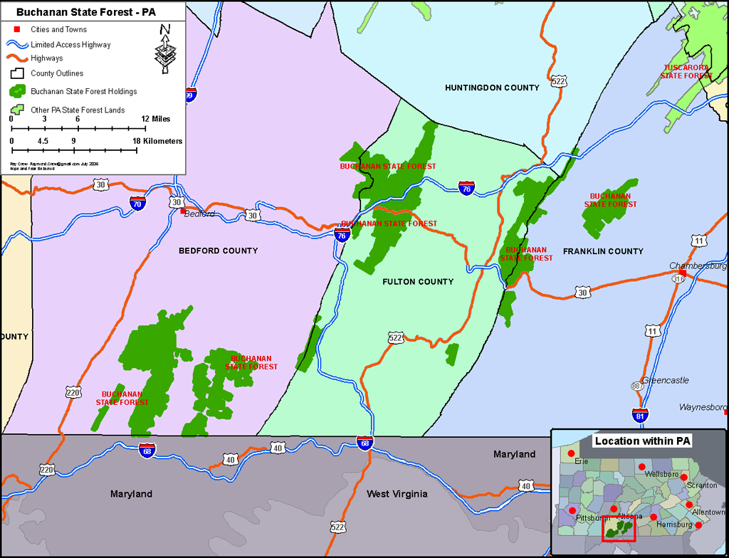
Pennsylvania , in theUnited States . It is named forJames Buchanan of Pennsylvania, the fifteenthPresident of the United States .The forest is found in the Allegheny Mountains of south-central Pennsylvania and comprises 75,000 acres (303.51 km²) divided into several units located in Bedford, Fulton, and Franklin Counties.
History
Buchanan State Forest was formed as a direct result of the depletion of the forests of Pennsylvania that took place during the mid to late 1800s. Conservationists like Dr.
Joseph Rothrock became concerned that the forests would not regrow if they were not managed properly. Lumber and Iron companies had harvested theold growth forest s for various reasons. The clear cut the forests and left behind nothing but dried tree tops and rotting stumps. The sparks of passingsteam locomotives ignitedwildfire s that prevented the formation ofsecond growth forest s. The conservationists feared that the forest would never regrow if there was not a change in the philosophy of forest management. They called for the state to purchase land from the lumber and iron companies and the lumber and iron companies were more than willing to sell their land since that had depleted the natural resources of the forests. cite web |url = http://www.dcnr.state.pa.us/forestry/stateforests/valleyforgehistory.aspx |title = History of the William Penn State Forest |accessdate = 2007-08-29 |publisher =Pennsylvania Department of Conservation and Natural Resources ] The changes began to take place in 1895 when Dr. Rothrock was appointed the first commissioner of the Pennsylvania Department of Forests and Waters, the forerunner of today'sPennsylvania Department of Conservation and Natural Resources . ThePennsylvania General Assembly passed a piece of legislation in 1897 that authorized the purchase of "unseated lands for forest reservations." This was the beginning of the State Forest system.There are several areas of historical significance in and around Buchanan State Forest. The Forbes Road built during the
French and Indian War by John Forbes passed through was is now Buchanan State Forest. Forbes built his road from Carlisle to Pittsburgh as a supply line for the British soldiers that were trying to captureFort Duquesne . Remnants of the road are still visible in the state forest and are used by visiting hunters, hikers and mountain bikers.Cowans Gap State Park is located in an area that was one of the first to be settled in this part of Pennsylvania. British Major John Cowan and his wife Mary who migrated to the area just after the American Revolution.Buchanan's Birthplace State Park the location of President James Buchanan's birth and his boyhood home. cite web |url = http://www.dcnr.state.pa.us/forestry/stateforests/buchananhistory.aspx |title = History of the Buchanan State Forest |accessdate = 2007-06-12 |publisher =Pennsylvania Department of Conservation and Natural Resources ]Buchanan State Forest was acquired by the Commonwealth of Pennsylvania following the lumber era that swept through most of Pennsylvania during the mid to late 1800s. Vast stands of
old growth forest s were harvested by various lumber companies. These lumber companies left behind a "barren wasteland" of stumps and drying treetops that were vulnerable to fire. cite web |url = http://www.dcnr.state.pa.us/stateparks/parks/laurelmountain.aspx |title = Laurel Mountain State Park |accessdate = 2007-06-12 |publisher =Pennsylvania Department of Conservation and Natural Resources ] The sparks cast off by passingsteam train s set off massive forest fires. These fires slowed the development of thesecond growth forest that now covers Buchanan State Forest. The forests have largely regrown with the hemlock and white pine trees being replaced with thriving populations of varioushardwood trees, thanks in large part to the efforts of the young men of theCivilian Conservation Corps during theGreat Depression .CCC Camp No. S-52 was built in 1933 on
Sideling Hill near Oregon Creek. The young men of the CCC cleared the forest and stream beds of dried underbrush and built many of the forest roads and trails that are in Buchanan State Forest. This camp is now known as Oregon Ranger Station. It also served as quarters forconscientious objector s duringWorld War II and was later turned into aPrisoner of War camp for German prisoners in 1944.An abandoned
aqueduct is hidden in Woodrige Hollow in Buchanan State Forest. It was constructed by several hundredstone mason s who were brought to Pennsylvania fromSicily by a railroad company in the 1880s. The aqueduct was completed in 1884 or 1885. It was constructed of nativesandstone and measures 15 feet high, 10 feet wide and is 199 feet in length. It was meant to carry water fromWoodridge Run beneath theSouth Penn Railroad that was being built across the northern portions of Fulton County through tunnels in Sideling andRays Hill s. The project was never completed, but much of the land cleared and the tunnels built by the railroad company was later used by the Pennsylvania Turnpike.Sideling Hill Tunnel is one of three originalPennsylvania Turnpike tunnel s which were abandoned (this one in1968 ) after two massive realignment projects. It is now surrounded by Buchanan State Forest. Sideling Hill Tunnel is 6782 feet (2067 meters) long. It was the longest of the original tunnels onPennsylvania Turnpike . Alongside theRays Hill Tunnel , the Sideling Hill Tunnel is now part of the Pike2Bike Trail. Together, the two tunnels as well as the roadway are commonly known as theAbandoned Pennsylvania Turnpike .weet Root Natural Area
Sweet Root Natural Area is a section of the Buchanan State Forest, located near
Chaneysville, Pennsylvania . As a state-designated Natural Area, Sweet Root is protected from almost all development, including roads and power transmission lines. The reserve protects the upper reaches of Sweet Root Run and thewater gap it has carved throughTussey Mountain . A grove ofold-growth hemlock is located in the gap, as well as the remains of an early mill and asaltpetre cave from the Revolutionary War. The saltpetre was used in the production ofgunpowder . Current reserve size is convert|1400|acre|km2.Nearby state parks and special areas
*
Cowans Gap State Park is located in Fulton and Franklin Counties within Buchanan State Forest.Special areas in Buchanan State Forest include Sweet Root Natural Area, Pine Ridge Natural Area, Martin Hill Wild Area, Redbud Valley (known for bird watching), and four
picnic areas.There are three other state parks in District #2:
*Buchanan's Birthplace State Park (Franklin County)
*Shawnee State Park (Bedford County)
*Warriors Path State Park (Bedford County)Neighboring State Forest Districts
The
U.S. state ofMaryland is to the south
*Rothrock State Forest (north)
*Tuscarora State Forest (northeast)
*Michaux State Forest (east)
*Forbes State Forest (west)
*Gallitzin State Forest (northwest)References
*cite web
url = http://www.dcnr.state.pa.us/forestry/stateforests/buchanan.aspx
title = Buchanan State Forest
accessdate = 2006-07-12
publisher =Pennsylvania Department of Conservation and Natural Resources
*cite web
url = http://www.dcnr.state.pa.us/forestry/images/district_realignment.gif
title = State Forest Districts
accessdate = 2006-07-12
publisher = Pennsylvania Department of Conservation and Natural Resources "Note: Map showing districts after the July 1, 2005 realignment"
Wikimedia Foundation. 2010.