- Montour Trail
-
Montour Trail 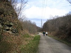
The Montour Trail between miles 3 and 4,
photo taken March 2006Length 59.3 mi (95.4 km) Location Allegheny County, Pennsylvania, USA Trailheads Coraopolis, Pennsylvania 40°30′17″N 80°08′42″W / 40.504794°N 80.144985°W to Clairton, Pennsylvania 40°18′18″N 79°53′02″W / 40.305091°N 79.883759°W Use Multi-use Trail difficulty Easy Season Year-round Sights see Points of Interest below The Montour Trail is a multi-use recreational rail trail near Pittsburgh, Pennsylvania.
It has a crushed limestone surface, appropriate for bicycling, walking, running, and cross-country skiing. Eventually, this trail segment will extend 47 miles (76 km) from Coraopolis, Pennsylvania to Clairton, Pennsylvania.
The trail is part of a 204-mile (328 km) rails to trails project between Pittsburgh and Cumberland, Maryland. When completed, it will be part of a 400-mile (640 km) trail system between Pittsburgh and Washington, D.C, known as the Great Allegheny Passage.
Contents
Upcoming Connecting Trails
- Panhandle Trail- the Montour Trail crosses over the Panhandle Trail on the McDonald Trestle. The Montour-Panhandle connector trail is approximately 1.1 miles (1.8 km) long and connects the two trails. The Panhandle stretches 29 miles (47 km) between Carnegie, PA, and Weirton, WV. The last unfinished section between Joffre and Burgettstown was finished in August 2008 and the trail is now complete.
- Great Allegheny Passage - an ambitious project set to link Cumberland, Maryland, and Point State Park in Pittsburgh. Another branch will extend to the Pittsburgh International Airport. The Great Allegheny Passage will, in turn, link to the historic Chesapeake and Ohio Canal, which runs from Cumberland to Washington, D.C.
- Ohio River Trail - A proposed trail that will connect the Montour Trail to the Great Ohio Lake-to-River Greenway in Ohio. When completed the trail will be an important link in a mega-trail system from the Great Lakes Region to Washington, D.C.
Points of interest
- McDonald Viaduct (Trestle) - formerly used by the Montour Railroad, the 960-foot (290 m) long trestle reopened in 2003. It spans over Noblestown Road, Robinson Run, the Panhandle Trail and John's Avenue in Washington County, PA.
- Enlow Tunnel - this Findlay Township tunnel was also formerly used by the Montour Railroad, until its incorporation into the trail. In 2000, Duquesne Light and Findlay Township installed lights inside the tunnel.
- National Tunnel - at 40°19′01″N 80°10′55″W / 40.317035°N 80.181838°WCoordinates: 40°19′01″N 80°10′55″W / 40.317035°N 80.181838°W, this Cecil Township tunnel was formerly used by the Montour Railroad and was abandoned with the railroad until it was acquired with the rail right-of-way in the 1980s by the Montour Trail Council (MTC). The tunnel is 623-foot (190 m) and is paved with asphalt pavement with reflectors for safe navigation.
- Library Trestle - this 506-foot (154 m) railroad trestle over Library Rd. (PA 88) in South Park was also formerly used by the Montour Railroad, until its incorporation into the trail. It is currently closed due to a lack of pavement and guardrails, with plans to renovate it for trail use in the near future.
- West Peters Trail Area - this approximately two mile section in Peters Township, PA of trail holds four amazing sites: the Greer Tunnel, two bridges directly adjacent to the tunnel, and the X-1 railroad service crane, a former working crane for the Montour Railroad. One of the bridges adjacent to the Greer Tunnel is the Chartiers Creek High Bridge, the highest bridge on the trail. A working railroad line also crosses directly under the trail in this area.
The Organization
The Montour Trail is managed and maintained by The Montour Trail Council (MTC). The MTC is a non-profit all-volunteer group which builds, operates, and maintains the trail. It is a registered 501(c)3 not-for-profit corporation, relying on corporate, foundation and government grants and private donations for funding.
External links
- Official Site
- Google Map of trail (including parts of Arrowhead Trail)
- Radio special on The Great Allegheny Passage, including a segment on The Montour Trail, by "The Allegheny Front"
- Montour Trail page at RailsToTrails.us
Hiking Trails in Pennsylvania 202 • Appalachian • Baker • Black Forest • Brandywine • Bucktail Path • Chester Valley • Chuck Keiper • Conestoga • Cresheim • Cross County • Darlington • Donut Hole • Evansburg • Forbes Road • GAP • GET • Glacier Ridge • Golden Eagle • Horse Shoe • John P. Saylor • Laurel Highlands • Liberty Bell • Lost Turkey • Lower • Loyalsock • Mason-Dixon • Mid State • Mill Creek • Montour • North Country • Old Loggers Path • Panhandle • Pennypack • Perkiomen • Pinchot • Potomac Heritage • Power Line • Quebec Run • Quehanna • Rachel Carson • Rock Run • Schuylkill East • Schuylkill River • Standing Stone • Struble • Susquehannock • Tanbark • Terrace Mountain • Thunder Swamp • Tuscarora • Valley Forge • Warrior • West County • West Rim • Wissahickon • Youghiogheny River

Rail Trails in Pennsylvania Abandoned Pennsylvania Turnpike • Beaver River • Cumberland Valley • East Coast Greenway • Ghost Town • Great Allegheny Passage • Great Shamokin • Indian Creek Valley • Lehigh Gorge • Liberty Bell • Lower • Montour • Ohio River • Panhandle • Perkiomen • Pine Creek • Schuylkill River • Struble • Switchback • Three Rivers Heritage • York County Heritage • Youghiogheny River
Categories:- Rail trails in Pennsylvania
- National Recreation Trails of the United States
- Protected areas of Allegheny County, Pennsylvania


Wikimedia Foundation. 2010.