- Cook Forest State Park
-
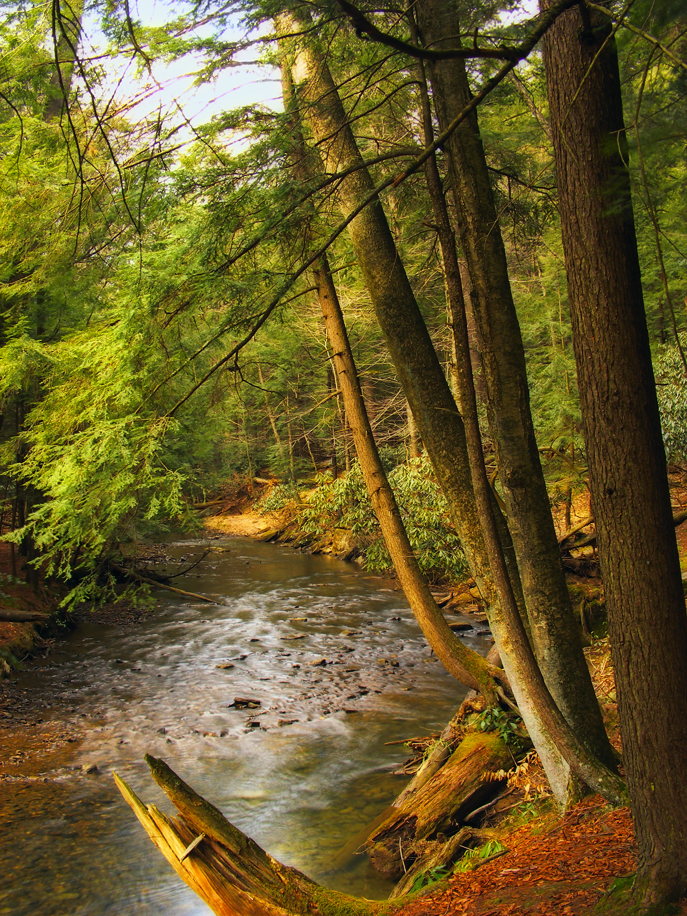
Cook Forest State Park Pennsylvania State Park Natural Monument (IUCN III) 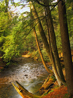 Tom's Run
Named for: John Cook Country United States State Pennsylvania Counties Clarion, Forest, Jefferson Townships Barnett, Barnett, Farmington Location [1] - coordinates 41°19′25″N 79°09′50″W / 41.32361°N 79.16389°WCoordinates: 41°19′25″N 79°09′50″W / 41.32361°N 79.16389°W - elevation 1,444 ft (440.1 m) [1] Area 8,500 acres (3,440 ha) Founded 1927 Managed by Pennsylvania Department of Conservation and Natural Resources Visitation 507,260 (in 2008) [2] 
 Location of Cook Forest State Park in Pennsylvania
Website : Cook Forest State Park Cook Forest State Park is a 8,500-acre (3,440 ha) Pennsylvania state park in Farmington Township, Clarion County, Barnett Township, Forest County and Barnett Township, Jefferson County, Pennsylvania in the United States. The park is a heavily wooded area of rolling hills and mountains along the Clarion River in northwestern Pennsylvania. Cook Forest State Park is known for some of America's finest virgin white pine and hemlock timber stands and was once called the "Black Forest" due to the preponderance of evergreen tree coverage.
Cook Forest is now a National Natural Landmark and was rated one of America's top 50 state parks by National Geographic Traveler magazine.[citation needed] It was chosen by the Pennsylvania Department of Conservation and Natural Resources (DCNR) and its Bureau of Parks as one of "Twenty Must-See Pennsylvania State Parks".[3]
Contents
History
When European-Americans reached this part of Pennsylvania it was inhabited by the Seneca Nation of the Iroquois Confederacy. They used this area as a hunting grounds; the land of Cook Forest was then purchased by the English. Seneca Rock is still named after the first inhabitants, and the Paramount Pictures' film "Unconquered" was shot here in 1946 by Cecil B. DeMille and starring Gary Cooper and Paulette Goddard.
John Cook was the first permanent American settler. He arrived in 1826 to determine the feasibility of building an east-to-west canal along the Clarion River for the Commonwealth of Pennsylvania. John purchased 765 acres (310 ha) and settled here with his wife and 10 children in 1828.[4]
At the mouth of Tom's Run, now adjacent to the park office, John built his one-story cabin and the first of many water-driven sawmills. He worked his mills, logged with oxen, rafted logs to Pittsburgh and also engaged in flatboat building through the years.[4]
John's son Andrew bought 36 acres (15 ha) from his father, then gained the rest of his land when his father died in 1858. Andrew's industry expanded, and he built the original Cook Forest Inn for his woodsmen's living quarters. Anthony erected three sawmills, one flouring mill, one planing mill, a boat scaffold, several dwellings and a store. Andrew also served as a judge and local bank president. About 1870, he built the Cook Homestead (now a bed and breakfast)at the intersection of Route 36 and River Road. Cook family descendants still inhabit many of the homes along River Road. After Andrew's death, the business was managed under A. Cook Sons Company.[4]
The Cook Forest Association formed in the 1920s to save the few areas of surviving old growth timber. Early pioneers in this effort were M. I. McCreight, Theo Wilson and John Nicholson. The Association, endorsed by national natural resource groups and Governor Gifford Pinchot, raised $200,000.[4]
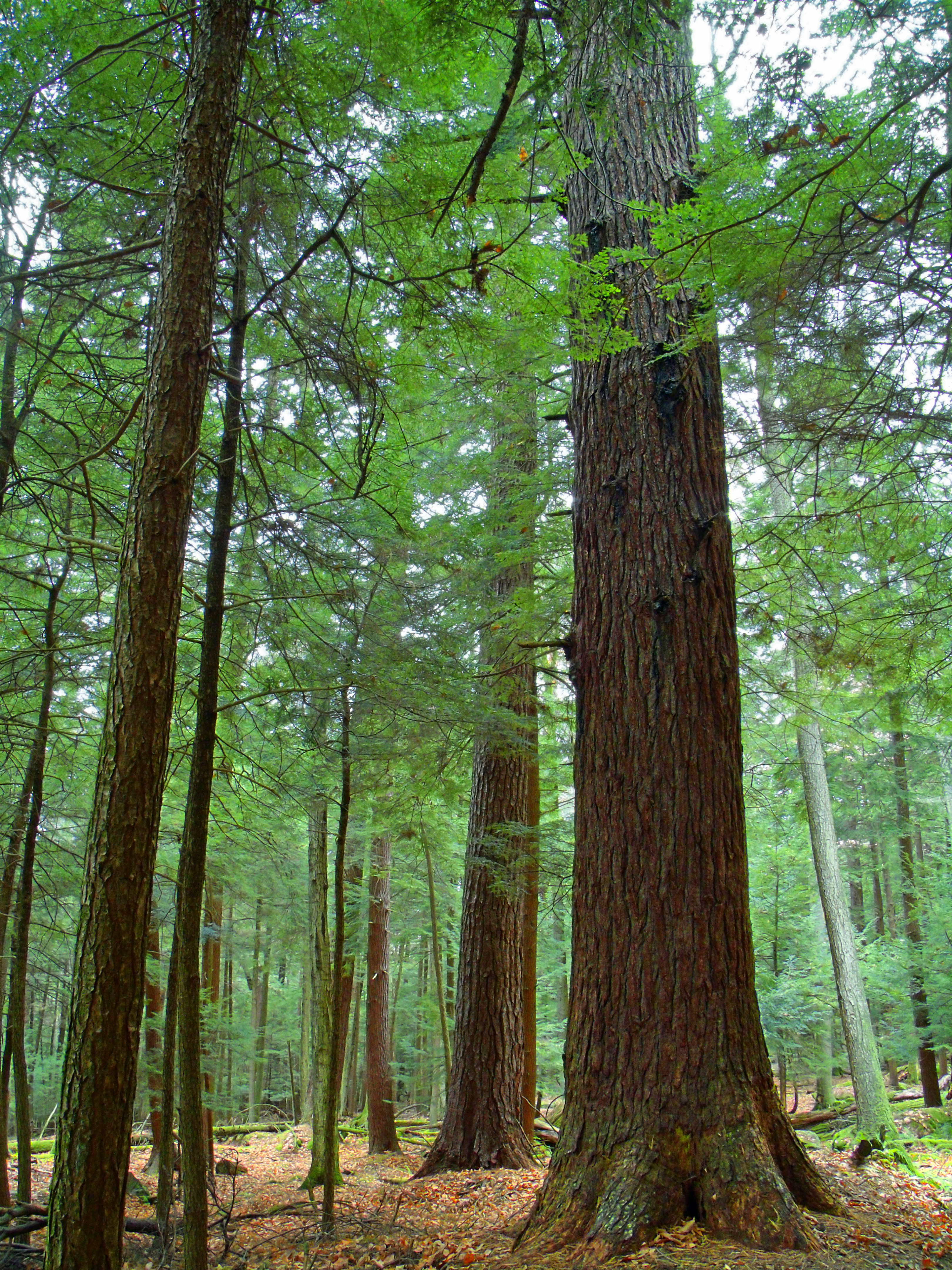
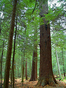 Old growth forest in the park
Money from the Association helped the Commonwealth purchase 6,055 acres (2,450 ha) from A. Cook Sons Company in 1927 for $640,000. Cook Forest became the first Pennsylvania State Park acquired to preserve a natural landmark.[4]
Built in 1929, a firetower was used to spot forest fires. It stands over 80 feet (24 m) tall. While no longer in use, the public can still climb to the top of the stairs. In addition, on rare occasions, the top spotting area will be opened by a guide to allow visitors a closer look.[4]
Ecology
See also: List of old growth forestsThe park is in the Allegheny Highlands forests ecoregion. It is famous for its spectacular stands of old-growth Eastern White Pine and Eastern Hemlock, with more white pine over 150 feet (46 m) in its Forest Cathedral than in any other site in the northeastern United States. Many of these ancient trees began growing after a drought and fire in 1644.[5] In total, there are some 1,500 acres (6.1 km2) to 2,000 acres (8.1 km2) of old-growth forests or old forests with old-growth characteristics in several stands throughout the park.[6] In addition to white pine and hemlock, old-growth Northern Red Oak, White Oak, Black Cherry, Red Maple, Sugar Maple, American Beech, White Ash, Yellow Birch, Black Birch, Cucumber Magnolia also grow throughout the park.[6]
Recreation
Cook Forest features 27 marked trails totaling some 29 miles (47 km) for hiking. The terrain is of rolling hills and cool valley streams. Special scenic areas are the old growth forest, Fire Tower/Seneca Point and the Clarion River. Among Cook Forest's primary attractions is the "Forest Cathedral" area of old growth white pine and hemlock, some trees of which top 180 feet (55 m). Part of the Baker Trail (140 miles (230 km)) and the North Country National Scenic Trail pass through Cook Forest. The Baker Trail runs from Freeport, in southern Armstrong County, to the Allegheny National Forest. The North Country Trail is under development and will connect the Missouri River in North Dakota with the Adirondack Mountains in New York.[4]
Bikes are permitted on all one-way dirt roads within the park. Biking on hiking trails is not permitted except on the part of the Heffern Run Trail that is part of the Bicycle Route. All children under 12 years of age are required to wear a helmet when biking. Bikes ridden at night must have a light on the bike. The Bicycle Route is 11.5 miles (18.5 km) long and follows lightly traveled roads within the park and Heffern Run Trail. The route is of moderate difficulty with long flat areas and rolling hills. Highlights of the route are a leisurely four-mile flat ride through scenic Tom's Run Valley, CCC-era red and white pine plantations along Forest Drive and a challenging descent along the Heffern Run Trail. A description of the Bicycle Route is available at the park office.[4]
The swimming pool is open daily from 11 a.m. to 7 p.m. from Memorial Day to Labor Day weekend, unless posted otherwise. Depths range from 2.5 feet (0.76 m) to 5 feet (1.5 m). A circular wading pool is adjacent to the large pool. Discounts are offered to campers. The pool area is accessible, and the pool is equipped with a lift. Vending machines have snacks and beverages. Visitors may swim in the Clarion River across from the ranger station or anywhere along public park land. Many local businesses provide canoeing and tubing along the relatively shallow and slow-moving river.[4]
Two designated bridle trails off Cemetery Road and portions of Brown's Run Trail comprise 4.5 miles (7.2 km) of trails for horseback riding. Several stables dot the area and are open to the public most of the year; these include Silver Stallion, Pine Crest, and the Cook Forest Scenic Trailride, Dude Ranch, and Campground.[4]
About 5,000 acres (2,000 ha) are open to hunting, trapping, and the training of dogs during established seasons. Common game species are deer, turkey, bear, and squirrel. Hunting woodchucks, also known as groundhogs, is prohibited. Dog training is only permitted from the day following Labor Day to March 31 in designated hunting areas. The Department of Conservation and Natural Resources and the Pennsylvania Game Commission rules and regulations apply. Contact the park office for accessible hunting information.[4]
The Clarion River flows along the park border and provides fishing for trout, warm-water game fish and panfish. Many visitors enjoy canoeing or kayaking down the river. There are also businesses that will rent you a canoe. About 2.5 miles (4.0 km) of Tom's Run is stocked with trout. A special fishing pond stocked with trout is by the park office and is available for use by children 12 and younger and people with a disability. A level grass bank at the edge of the pond provides easy access. For complete information on fishing rules and regulations in Pennsylvania, visit the Pennsylvania Fish and Boat Commission.[4]
Education
Programs for all ages are offered March to December. Through hands-on activities, guided walks and evening programs, participants gain appreciation, understanding and develop a sense of stewardship toward natural and cultural resources.[4]
Curriculum-based environmental education programs are available to schools and youth groups. Teacher workshops are available. Group programs must be scheduled in advance by calling the park office.[4]
A weekly interpretive schedule is available at the park office. The park has an environmental learning center in the Log Cabin Inn at the Main Picnic Area. The Historical Room displays logging and rafting tools, models and artifacts.[4]
The fire tower is always open for climbing during daylight hours, and the booth at its top is occasionally opened by a ranger for exhibition; check at the park office for a schedule.[4]
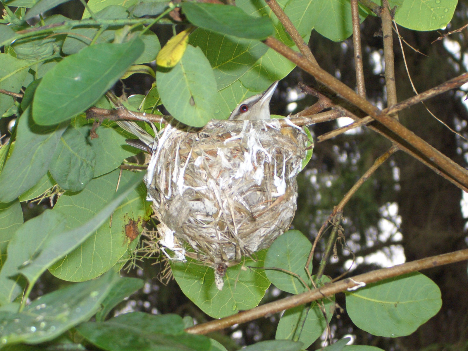
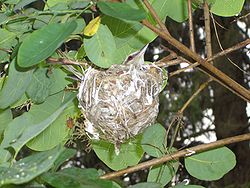 A Red-eyed vireo in its nest at Cook Forest State Park
A local, non-profit craft organization housed in the historic sawmill offers traditional crafts on display, a gift shop and classes. Demonstrations and classes on various crafts are presented throughout the summer and fall seasons for children and adults. The Verna Leith Sawmill Theater seats 180 people and presents plays, musicals and other entertainment throughout the summer season.[4]
Accommodations
The 24 rustic cabins rent from the second Friday in April to late December. All cabins are minimally furnished. Each cabin has beds, mattresses, gas stove, refrigerator, and tables and chairs. Occupants must provide their own bedding, cookware and tableware. Alcoholic beverages and pets are not permitted. There are two cabin areas at Cook Forest. The River Cabins are on a hillside overlooking the Clarion River. Two River Cabins have one room and sleep four people and the other 11 River Cabins have four rooms, a fireplace and sleep six or eight people. The Indian Cabins are along Tom's Run behind the park office. These smaller, one-room cabins sleep four people.[4][7]
Part of Ridge Campground is open year-round. Winter access is not guaranteed. Modern restrooms with showers are available late May through early October. The 226 tent and trailer campsites have a picnic table and fire ring, and six sites are ADA accessible. There is a sanitary dump station and coin-operated laundry facilities.[4]
Nearby state parks
The following state parks are within 30 miles (48 km) of Cook Forest State Park:[8][9][10][11][12]
- Chapman State Park (Warren County)
- Clear Creek State Park (Jefferson County)
- Oil Creek State Park (Venango County)
References
- ^ a b "Cook Forest State Park". Geographic Names Information System. United States Geological Survey. August 2, 1979. http://geonames.usgs.gov/pls/gnispublic/f?p=gnispq:3:::NO::P3_FID:1210157. Retrieved 2008-02-10.
- ^ Hopey, Dan. "Cutbacks put some state parks on shaky ground". Pittsburgh Post-Gazette. http://www.postgazette.com/pg/09144/972400-455.stm. Retrieved 2009-05-24.
- ^ "Twenty Must-See Pennsylvania State Parks". Pennsylvania Department of Conservation and Natural Resources. http://www.dcnr.state.pa.us/stateparks/twenty/20parks.aspx. Retrieved 2007-08-08. Note: Despite the title, there are twenty-one parks in the list, with Colton Point and Leonard Harrison State Parks treated as one.
- ^ a b c d e f g h i j k l m n o p q r s "Cook Forest State Park". Pennsylvania Department of Conservation and Natural Resources. http://www.dcnr.state.pa.us/stateparks/findapark/cookforest/index.htm. Retrieved 2006-11-28.
- ^ Mary Byrd Davis (23 January 2008). "Old Growth in the East: A Survey. Pennsylvania". http://www.primalnature.org/ogeast/pa.pdf.
- ^ a b Dale J. Luthringer, Environmental Education Specialist, Cook Forest State Park (2002-03-04). "Cook Forest old growth areas & big tree locations". Eastern Native Tree Society. http://www.nativetreesociety.org/fieldtrips/penna_cook_forest/cook_forest_old_growth02.htm. Retrieved 2009-01-25.
- ^ "Pennsylvania State Parks: The CCC Years". Pennsylvania Department of Conservation and Natural Resources. http://www.dcnr.state.pa.us/stateparks/history/historycccyears.aspx. Retrieved 2006-11-28.
- ^ Pennsylvania Department of Transportation, Bureau of Planning and Research, Geographic Information Division. 2007 General Highway Map Clarion County Pennsylvania (Map). 1:65,000. ftp://ftp.dot.state.pa.us/public/pdf/BPR_pdf_files/Maps/GHS/Roadnames/clarion_GHSN.pdf. Retrieved 2007-07-27. Note: shows Cook Forest State Park
- ^ Pennsylvania Department of Transportation, Bureau of Planning and Research, Geographic Information Division. 2007 General Highway Map Forest County Pennsylvania (Map). 1:65,000. ftp://ftp.dot.state.pa.us/public/pdf/BPR_pdf_files/Maps/GHS/Roadnames/forest_GHSN.pdf. Retrieved 2007-07-27. Note: shows Cook Forest State Park
- ^ Pennsylvania Department of Transportation, Bureau of Planning and Research, Geographic Information Division. 2007 General Highway Map Jefferson County Pennsylvania (Map). 1:65,000. ftp://ftp.dot.state.pa.us/public/pdf/BPR_pdf_files/Maps/GHS/Roadnames/jefferson_GHSN.pdf. Retrieved 2007-07-27. Note: shows Cook Forest State Park
- ^ Michels, Chris (1997). "Latitude/Longitude Distance Calculation". Northern Arizona University. http://www2.nau.edu/~cvm/latlongdist.html. Retrieved 2008-04-20.
- ^ "Find a Park by Region (interactive map)". Pennsylvania Department of Conservation and Natural Resources. http://www.dcnr.state.pa.us/stateparks/findapark/where/index.htm. Retrieved November 18, 2011.
External links
- Park website
- Cook Forest State Park official mapPDF (854 KB)
U.S. National Register of Historic Places Topics Lists by states Alabama • Alaska • Arizona • Arkansas • California • Colorado • Connecticut • Delaware • Florida • Georgia • Hawaii • Idaho • Illinois • Indiana • Iowa • Kansas • Kentucky • Louisiana • Maine • Maryland • Massachusetts • Michigan • Minnesota • Mississippi • Missouri • Montana • Nebraska • Nevada • New Hampshire • New Jersey • New Mexico • New York • North Carolina • North Dakota • Ohio • Oklahoma • Oregon • Pennsylvania • Rhode Island • South Carolina • South Dakota • Tennessee • Texas • Utah • Vermont • Virginia • Washington • West Virginia • Wisconsin • WyomingLists by territories Lists by associated states Other Categories:- Pennsylvania state parks
- National Natural Landmarks in Pennsylvania
- National Register of Historic Places in Pennsylvania
- Protected areas established in 1927
- Old growth forests
- Parks in Clarion County, Pennsylvania
- Parks in Forest County, Pennsylvania
- Parks in Jefferson County, Pennsylvania

Wikimedia Foundation. 2010.