- Ralph Stover State Park
Geobox Protected Area
name = Ralph Stover State Park
native_name =
other_name =
other_name1 =
category_local = Pennsylvania State Park
category_iucn = III
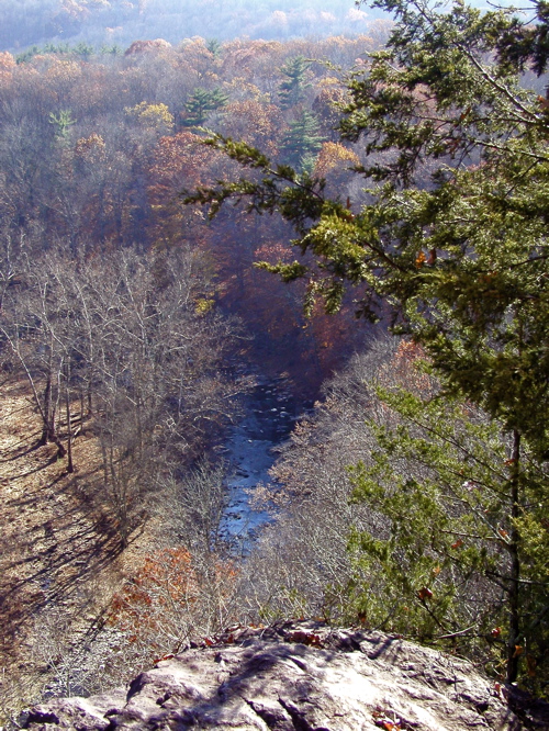
image_caption = The view of Tohickon Creek from the top of High Rocks during autumn.
etymology_type = Named for
etymology = Ralph Stover
country = United States
state = Pennsylvania
region_type = County
region = Bucks
district_type = Townships
district = Plumstead
district1 = Tinicum
city =
city1 =
location =
lat_d = 40
lat_m = 26
lat_s = 04
lat_NS = N
long_d = 75
long_m = 05
long_s = 55
long_EW = W
location_note = cite web | url=Gnis3|1184613 | title=Ralph Stover State Park | date =August 2 1979 | work=Geographic Names Information System | publisher=United States Geological Survey | accessdate=2007-12-22]
elevation_imperial = 256
elevation_round = 1
elevation_note =
area_unit = acre
area_imperial = 45
area_round = 1
area_note =
area1_imperial =
area1_type =
length_imperial =
length_orientation =
width_imperial =
width_orientation =
highest =
highest location =
highest_lat_d =
highest_lat_m =
highest_lat_s =
highest_lat_NS =
highest_long_d =
highest_long_m =
highest_long_s =
highest_long_EW =
highest_elevation_imperial =
lowest =
lowest_location =
lowest_lat_d =
lowest_lat_m =
lowest_lat_s =
lowest_lat_NS =
lowest_long_d =
lowest_long_m =
lowest_long_s =
lowest_long_EW =
lowest_elevation_imperial =
biome =
biome_share =
biome1 =
biome1_share =
geology =
geology1 =
plant =
plant1 =
animal =
animal1 =
established_type =
established = 1931
established_note =
established1_type =
established1 =
management_body = Pennsylvania Department of Conservation and Natural Resources
management_location =
management_lat_d =
management_lat_m =
management_lat_s =
management_lat_NS =
management_long_d =
management_long_m =
management_long_s =
management_long_EW =
management_elevation =
visitation =
visitation_year =
free_type = Nearest city
free =Doylestown, Pennsylvania
free1_type =
free1 =

map_caption = Location of Ralph Stover State Park in Pennsylvania
map_locator = Pennsylvania
map_first =
website = [http://www.dcnr.state.pa.us/stateparks/parks/ralphstover.aspx Ralph Stover State Park]Ralph Stover State Park is a Pennsylvania State Park on convert|45|acre|km2|2 in Plumstead and Tinicum Townships, Bucks County,
Pennsylvania in the United States. It is a very popular destination forwhitewater kayaking onTohickon Creek androck climbing on a geologic formation known as High Rocks. Ralph Stover State Park is two miles (3.22 km) north of Point Pleasant nearPennsylvania Route 32 .History
Tohickon Creek was named by the
Lenape some of the first inhabitants of the area. "To-Hick-Hanne" means "Deer-Bone-Creek". Ralph Stover State Park was the site of an 18th centurygristmill that was built on Tohickon Creek by the park's namesake,Ralph Stover . Remnants of the mill andmill race can still be seen near Tohickon Creek.The Stover family gave their land to the Commonwealth of Pennsylvania in 1931. The recreational facilities were built during the
Great Depression by the FederalWorks Progress Administration created by U.S. PresidentFranklin D. Roosevelt to provide work for the unemployed. AuthorJames A. Michener donated the High Rocks area to the park in 1956. Although "High Rocks State Park" is listed in theUnited States Geological Survey Geographic Names Information System and the coordinates given in USGS GNIS are located here, it was never an official name according to thePennsylvania Department of Conservation and Natural Resources or a separate park.Recreation
High Rocks is a convert|200|ft|m|0 sheer rock face that is a challenge to even the most experienced rock climbers. The climbing varieties include top rope, traditional, mixed, and boulder climbing. [cite web
url = http://www.climbingsource.com/LocalBeta/Pennsylvania/ralphstover.html
title = Rock Climbing at Ralph Stover State Park | accessdate = 2006-11-21 | publisher = Climbing Source ]Tohickon Creek offers whitewater conditions for kayaking in the spring with the winter snow melt and several times a year when water is released from
Lake Nockamixon . The creek is also a warm water fishery withsmallmouth bass , sunfish,carp andcatfish . ThePennsylvania Fish and Boat Commission also stocks the creek withtrout .cite web
url = http://www.dcnr.state.pa.us/stateparks/Parks/ralphstover.aspx
title = Ralph Stover State Park | accessdate = 2006-11-21 | publisher =Pennsylvania Department of Conservation and Natural Resources ]A hiking trail of convert|1|mi|km|1 passes the millrace. There is a shaded picnic area along Tohickon Creek and a scenic vista at the top of High Rocks.
Nearby state parks
The following state parks are within convert|30|mi|km|0 of Ralph Stover State Park: [cite web | url = http://www.dcnr.state.pa.us/stateparks/parks/region_philadelphia.aspx
title = Map Reference for Ralph Stover State Park | accessdate = 2006-11-21 | publisher =Pennsylvania Department of Conservation and Natural Resources ] cite web
last = Michels
first = Chris
year = 1997
url = http://www2.nau.edu/~cvm/latlongdist.html
title = Latitude/Longitude Distance Calculation
publisher =Northern Arizona University
accessdate = 2008-04-23] [cite map |scale = 1:65,000| publisher= Pennsylvania Department of Transportation, Bureau of Planning and Research, Geographic Information Division | url= ftp://ftp.dot.state.pa.us/public/pdf/BPR_pdf_files/Maps/GHS/Roadnames/bucks_GHSN.PDF | title= 2007 General Highway Map Bucks County Pennsylvania | accessdate= 2006-07-27 "Note: shows Ralph Stover State Park"]
*Benjamin Rush State Park (Philadelphia County)
*Bull's Island Recreation Area (New Jersey )
*Delaware and Raritan Canal State Park (New Jersey)
*Delaware Canal State Park (Bucks and Northampton Counties)
*Evansburg State Park (Montgomery County)
*Fort Washington State Park (Montgomery County)
*Hacklebarney State Park (New Jersey)
*Jacobsburg Environmental Education Center (Northampton County)
*Neshaminy State Park (Bucks County)
*Nockamixon State Park (Bucks County)
*Norristown Farm Park (Montgomery County)
*Spruce Run State Park (New Jersey)
*Round Valley State Park (New Jersey)
*Tyler State Park (Bucks County)
*Voorhees State Park (New Jersey)
*Washington Crossing State Park (New Jersey)References
External links
*
Wikimedia Foundation. 2010.