- Tyler State Park (Pennsylvania)
Geobox Protected Area
name = Tyler State Park
native_name =
other_name =
other_name1 =
category_local = Pennsylvania State Park
category_iucn = III
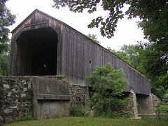
image_caption = Schofield Ford Covered Bridge
etymology_type = Named for
etymology = Mr. and Mrs. George F. Tyler
country = United States
state = Pennsylvania
region_type = County
region = Bucks
district_type = Townships
district = Newtown
district1 = Northhampton
city =
city1 =
location =
lat_d = 40
lat_m = 13
lat_s = 30
lat_NS = N
long_d = 74
long_m = 59
long_s = 00
long_EW = W
location_note = cite web
url=Gnis3|1198258
title="Tyler State Park"
date =August 30 1990
work=Geographic Names Information System
publisher=United States Geological Survey
accessdate=2007-12-13]
elevation_imperial = 236
elevation_round = 1
elevation_note =
area_unit = acre
area_imperial = 1711
area_round = 1
area1_imperial =
area1_type =
length_imperial =
length_orientation =
width_imperial =
width_orientation =
highest =
highest location =
highest_lat_d =
highest_lat_m =
highest_lat_s =
highest_lat_NS =
highest_long_d =
highest_long_m =
highest_long_s =
highest_long_EW =
highest_elevation_imperial =
lowest =
lowest_location =
lowest_lat_d =
lowest_lat_m =
lowest_lat_s =
lowest_lat_NS =
lowest_long_d =
lowest_long_m =
lowest_long_s =
lowest_long_EW =
lowest_elevation_imperial =
biome =
biome_share =
biome1 =
biome1_share =
geology =
geology1 =
plant =
plant1 =
animal =
animal1 =
established_type =
established = 1974
established1_type =
established1 =
management_body = Pennsylvania Department of Conservation and Natural Resources
management_location =
management_lat_d =
management_lat_m =
management_lat_s =
management_lat_NS =
management_long_d =
management_long_m =
management_long_s =
management_long_EW =
management_elevation =
visitation =
visitation_year =
free_type = Nearest city
free =Newtown, Pennsylvania
free1_type =
free1 =

map_caption = Location of Tyler State Park in Pennsylvania
map_locator = Pennsylvania
map_first =
website = [http://www.dcnr.state.pa.us/stateparks/parks/tyler.aspx Tyler State Park]Tyler State Park is a Pennsylvania state park on convert|1711|acre|km2|2 in Newtown and Northhampton Townships, Bucks County,
Pennsylvania in the United States. [cite web | url = http://www.dcnr.state.pa.us/StateParks/parks/tyler.aspx | title = Tyler State Park | accessdate = 2007-12-13 | publisher = PA DCNR]Park roads, trails, and facilities are carefully nestled within the original farm and woodland setting. The
Neshaminy Creek meanders through the park, dividing the land into several sections. Before becoming a state park, the land was owned by Mr. and Mrs. George F. Tyler who purchased the land between 1919 and 1928. Their first purchase was the Solly Farm, currently leased to Hostelling International at the north end of the park. The Solly House served as the Tyler’s country home until the mansion was constructed. The mansion is now the administration building of theBucks County Community College .The Tylers developed one of the finest Ayrshire dairy herds in the county. In addition, they raised poultry, sheep and pigs, and had a stable of about 25 fine riding horses. The productive croplands were mainly used to supply feed for the livestock.
Old original stone dwellings in the park stand as fine examples of early farm dwellings of rural Pennsylvania. Some structures date back to the early 1700s. A date stone (1775) can be found on a house located by the bicycle trail north of the pedestrian causeway in the center of the park. Ten original farm dwellings are currently being leased as private residences.
Tyler State Park contains a 27-hole
disc golf course.One of the main attractions in the park is the Schofield Ford Covered Bridge, originally built in 1874. The bridge burned down due to arson on
October 7 ,1991 , but was rebuilt with raised funds and reopened onSeptember 7 ,1997 . [cite news|title=Burned bridges meet different fates|last=Madsen|first=Kelly|url=http://www.phillyburbs.com/pb-dyn/news/.html|publisher=The Intelligencer|accessdate=]Nearby state parks
The following state parks are within convert|30|mi|km|0 of Tyler State Park: [cite map |scale = 1:65,000| publisher= Pennsylvania Department of Transportation, Bureau of Planning and Research, Geographic Information Division
url= ftp://ftp.dot.state.pa.us/public/pdf/BPR_pdf_files/Maps/GHS/Roadnames/bucks_GHSN.PDF
title= 2007 General Highway Map Bucks County Pennsylvania
accessdate= "Note: shows Tyler State Park"] cite web
last = Michels
first = Chris
year = 1997
url = http://www2.nau.edu/~cvm/latlongdist.html
title = "Latitude/Longitude Distance Calculation"
publisher =Northern Arizona University
accessdate = 2008-04-23]
*Benjamin Rush State Park (Philadelphia County)
*Bull's Island Recreation Area (Hunterdon County, New Jersey )
*Delaware and Raritan Canal State Park (Somerset County, New Jersey )
*Delaware Canal State Park (Bucks and Northampton Counties)
*Evansburg State Park (Montgomery County)
*Fort Washington State Park (Montgomery County)
*Neshaminy State Park (Bucks County)
*Nockamixon State Park (Bucks County)
*Norristown Farm Park (Montgomery County)
*Ralph Stover State Park (Bucks County)
*Rancocas State Park (Burlington County, New Jersey )
*Round Valley State Park (Hunterdon County, New Jersey)
*Spruce Run State Park (Hunterdon County, New Jersey)
*Washington Crossing State Park (Mercer County, New Jersey )References
External links
*
Wikimedia Foundation. 2010.