- Allegheny Islands State Park
Geobox Protected Area
name = Allegheny Islands State Park
native_name =
other_name =
other_name1 =
category_local = Pennsylvania State Park
category_iucn = III
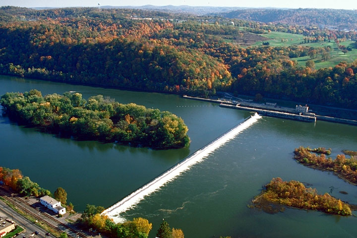
image_caption = The eastern part of Allegheny Islands State Park and the C.W. Bill Young Lock and Dam (#3) on the Allegheny River
etymology_type = Named for
etymology =Allegheny River islands
country = United States
state = Pennsylvania
region_type = County
region = Allegheny
district_type = Township
district = Harmar
city =
location =
lat_d = 40
lat_m = 32
lat_s = 09
lat_NS = N
long_d = 79
long_m = 49
long_s = 44
long_EW = W
location_note = cite web
url=Gnis3|2351323
title=Allegheny Islands State Park
date =August 27 2007
work=Geographic Names Information System
publisher=United States Geological Survey
accessdate=2008-04-02]
elevation_imperial = 735
elevation_round = 1
elevation_note =
area_unit = acre
area_imperial = 43
area_round = 1
area1_imperial =
area1_type =
length_imperial =
length_orientation =
width_imperial =
width_orientation =
highest =
highest location =
highest_lat_d =
highest_lat_m =
highest_lat_s =
highest_lat_NS =
highest_long_d =
highest_long_m =
highest_long_s =
highest_long_EW =
highest_elevation_imperial =
lowest =
lowest_location =
lowest_lat_d =
lowest_lat_m =
lowest_lat_s =
lowest_lat_NS =
lowest_long_d =
lowest_long_m =
lowest_long_s =
lowest_long_EW =
lowest_elevation_imperial =
biome =
biome_share =
biome1 =
biome1_share =
geology =
geology1 =
plant =
plant1 =
animal =
animal1 =
established_type =
established = 1980
management_body = Pennsylvania Department of Conservation and Natural Resources
management_location =
management_lat_d =
management_lat_m =
management_lat_s =
management_lat_NS =
management_long_d =
management_long_m =
management_long_s =
management_long_EW =
management_elevation =
visitation =
visitation_year =
free_type = Nearest city
free = Pittsburgh
free1_type =
free1 =

map_caption = Location of Allegheny Islands State Park in Pennsylvania
map_locator = Pennsylvania
map_first =
website = [http://www.dcnr.state.pa.us/stateparks/parks/alleghenyislands.aspx Allegheny Islands State Park]Allegheny Islands State Park is a convert|43|acre|km2|2|adj=on Pennsylvania State Park in Harmar Township, Allegheny County,
Pennsylvania in the United States. The undeveloped park is composed of threealluvial islands located in the middle of theAllegheny River northeast of Pittsburgh.cite web
url = http://www.dcnr.state.pa.us/stateparks/parks/alleghenyislands.aspx | title = Allegheny Islands State Park | accessdate = 2006-09-17 | publisher = Pennsylvania Department of Conservation and Natural Resources ] The islands are just north of the boroughs of Oakmont and Plum, and southwest of Cheswick.cite map |scale = 1:65,000| publisher = Pennsylvania Department of Transportation, Bureau of Planning and Research, Geographic Information Division | url= ftp://ftp.dot.state.pa.us/public/pdf/BPR_pdf_files/Maps/GHS/Roadnames/allegheny_GHSN.PDF | title= 2007 General Highway Map Allegheny County Pennsylvania | accessdate= 2007-07-27 "Note: shows Allegheny River and its islands" ] [cite web | url = http://www.alleghenyridge.org/greenwaybook/11X17%20maps/pitt_11x17.pdf | title = The Mainline Canal Greenway: Pittsburgh Trail Map | accessdate = 2006-09-17 | publisher = Greenways Incorporated |format=PDF "Note: shows Allegheny Islands State Park"] Bridges for thePennsylvania Turnpike (Interstate 76) and theBessemer and Lake Erie Railroad Branch of theCanadian National Railway cross the Allegheny River at the middle island.cite map |scale = 1' - 1500" | publisher|url= http://www.lrp.usace.army.mil/navchart/al/chart5.pdf |title= Allegheny River Chart No. 5 (Pennsylvania, Allegheny County): Twelve Mile Island, Fourteen Mile Island, C.W. Bill Young Lock & Dam Pool |accessdate= 2007-08-25 |date= January 2004 |publisher= United States Army Corps of Engineers, Pittsburgh District|format=PDF ]Islands
The park land on the islands has a total area of convert|43|acre|km2|2, with two islands downstream of the Allegheny River Lock and Dam No. 3 (officially the "C.W. Bill Young Lock & Dam"), and the other island upstream. Twelve Mile Island is the furthest downstream (west) and has a number of houses and buildings on the western four-fifths of the island (the park land is the eastern end). cite map |scale = 1:24,000| publisher
url = http://www.topoquest.com/map.asp?latd=40&latm=32&lats=14&lond=79&lonm=49&lons=17&datum=NAD83&u=6 | title = USGS New Kensington West (PA) Topo Map | accessdate = 2008-07-05 | cartography =United States Geological Survey | publisher = TopoQuest] The remaining two islands are both uninhabited and have no structures on them. They were originally one island named Fourteen Mile Island, but were split into two parts by the construction of the dam. [cite web | url = http://www.dcnr.state.pa.us/brc/rivers/riversconservation/registry/62chap1.pdf |title = Three Rivers Conservation Plan, Chapter One: Project Area Characteristics | author = Pennsylvania Environmental Council | accessdate = 2008-04-11 | publisher = Pennsylvania Department of Conservation and Natural Resources |format=PDF] Today the name Fourteen Mile Island is given to the middle island, just downstream (west) of the dam, and it is the site of the highway and railroad bridges. According to the USGS GNIS, the last island (which was once part of Fourteen Mile Island) is unnamed (although it is still labeled "Fourteen Mile Island" on the U.S. Army Corps of Engineers navigation maps of the Allegheny River.)cite web | last = Geographic Names Information System | first =United States Geological Survey | date =August 27 ,2007 | url =Gnis3|2351323 | title =Geographic Names Information System Feature Detail Report: Allegheny Islands State Park | accessdate =2007-08-28] cite map |scale = 1' - 1500" |url= http://www.lrp.usace.army.mil/navchart/al/chart6.pdf |title= Allegheny River Chart No. 6 (Pennsylvania, Allegheny County): Springdale, New Kensington |accessdate= 2007-08-25 |date= January 2004 |publisher= United States Army Corps of Engineers, Pittsburgh District|format=PDF ] This unnamed island is the easternmost and the only one upstream of the dam. There are also five to sevenshoal s near the islands, which are occasionally exposed.Twelve Mile and Fourteen Mile Islands are named for their distances (convert|12|mi|0 and convert|14|mi|0) along the Allegheny River to the confluence of the Allegheny and
Monongahela River s to form theOhio River in downtown Pittsburgh. They are two of six alluvial islands in the Allegheny River near Pittsburgh (for comparison, near Pittsburgh the Ohio River has only three islands and the Monongahela River has none). "The large number of islands in the Allegheny is a reflection of the large amount of glacially-derived sediment that was moved by the river." [cite web |url= http://www.geology.pitt.edu/GeoSites/site%20PGHBW%204-3new.htm |title= Site: PGHBW 4-3, A View of the Point from Grandview Avenue, Pittsburgh, PA |accessdate= 2007-08-25 |publisher=University of Pittsburgh , Department of Geology ]Facilities
Allegheny Islands State Park was established on
December 31 1980 .As of 2007 , it is undeveloped so that there are no facilities, and also no plans for future development. The park can only be accessed by boat.Camping is allowed on the islands and they are open for visits by groups such as theBoy Scout s andVenture Outdoors . Allegheny Islands State Park is administered from the Region 2 Office inProspect, Pennsylvania .Nearby state parks
The following state parks are within convert|30|mi|0 of Allegheny Islands State Park:cite web
last = Michels
first = Chris
year = 1997
url = http://www2.nau.edu/~cvm/latlongdist.html
title = Latitude/Longitude Distance Calculation
publisher =Northern Arizona University
accessdate = 2008-04-15]
*Hillman State Park (Washington County)
*Keystone State Park (Westmoreland County)
*Point State Park (Allegheny County)References
External links
Wikimedia Foundation. 2010.