- Salt Springs State Park
Geobox Protected Area
name = Salt Springs State Park
native_name =
other_name =
other_name1 =
category_local = Pennsylvania State Park
category_iucn = III
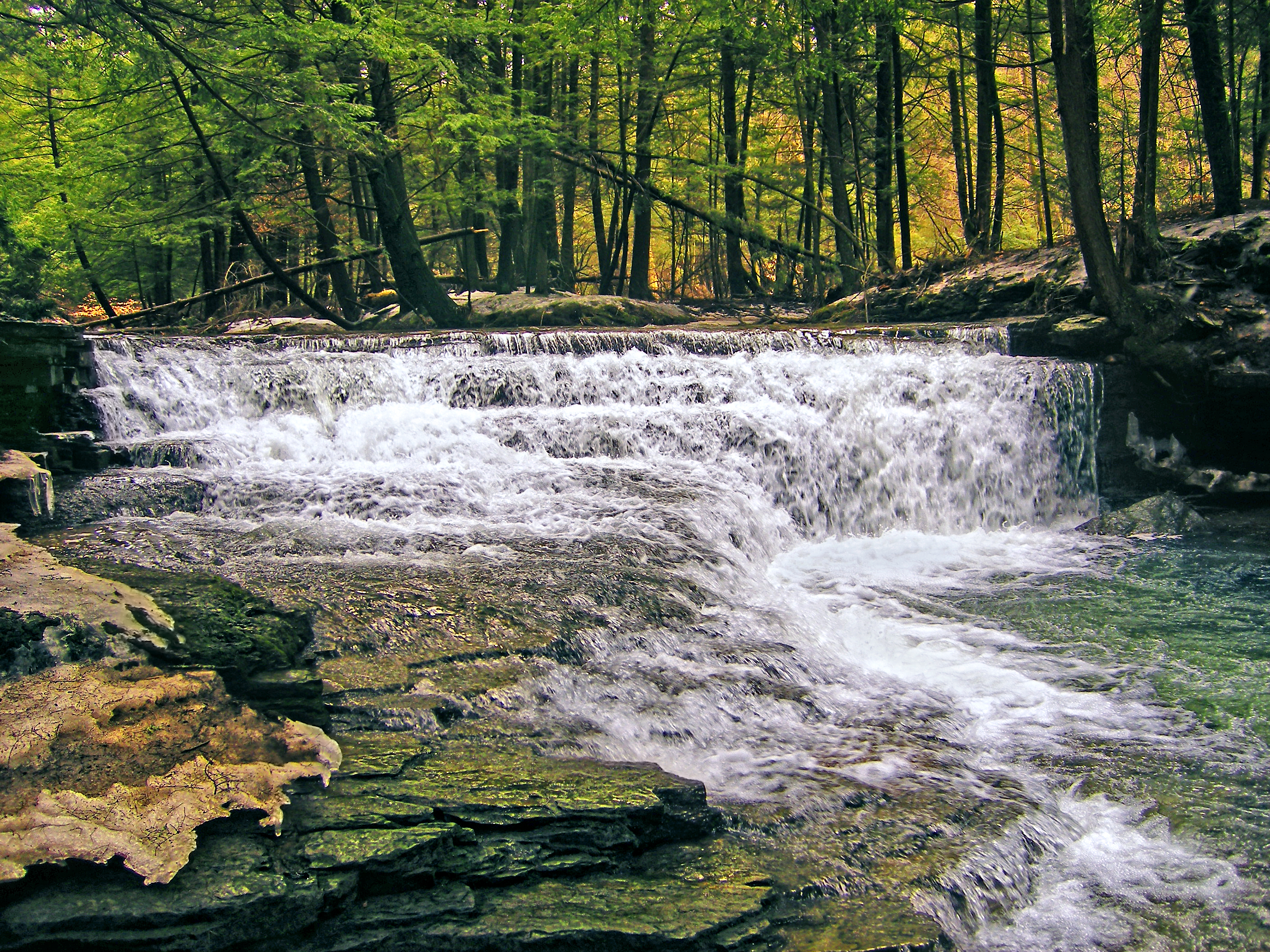
image_caption = Fall Brook passes through Salt Springs State Park
etymology_type =
etymology =
country = United States
state = Pennsylvania
region_type = County
region = Susquehanna
district_type = Township
district = Franklin
city =
location =
lat_d = 41
lat_m = 54
lat_s = 50
lat_NS = N
long_d = 75
long_m = 51
long_s = 59
long_EW = W
location_note = cite web | url=Gnis3|1196515 | title="Salt Springs State Park" | date =August 30 1990 | work=Geographic Names Information System | publisher=United States Geological Survey | accessdate=2007-12-18]
elevation_imperial = 1211
elevation_round = 1
elevation_note =
area_unit = acre
area_imperial = 405
area_round = 1
area_note =
area1_imperial =
area1_type =
length_imperial =
length_orientation =
width_imperial =
width_orientation =
highest =
highest location =
highest_lat_d =
highest_lat_m =
highest_lat_s =
highest_lat_NS =
highest_long_d =
highest_long_m =
highest_long_s =
highest_long_EW =
highest_elevation_imperial =
lowest =
lowest_location =
lowest_lat_d =
lowest_lat_m =
lowest_lat_s =
lowest_lat_NS =
lowest_long_d =
lowest_long_m =
lowest_long_s =
lowest_long_EW =
lowest_elevation_imperial =
biome =
biome_share =
biome1 =
biome1_share =
geology =
geology1 =
plant =
plant1 =
animal =
animal1 =
established_type =
established = 1973
management_body = Pennsylvania Department of Conservation and Natural Resources
management_location =
management_lat_d =
management_lat_m =
management_lat_s =
management_lat_NS =
management_long_d =
management_long_m =
management_long_s =
management_long_EW =
management_elevation =
visitation =
visitation_year =
free_type = Nearest city
free =Montrose, Pennsylvania
free1_type =
free1 =

map_caption = Location of Salt Springs State Park in Pennsylvania
map_locator = Pennsylvania
map_first =
website = [http://www.dcnr.state.pa.us/stateparks/parks/saltsprings.aspx Salt Springs State Park]Salt Springs State Park is a Pennsylvania state park in Franklin Township, Susquehanna County,
Pennsylvania , in the United States. The park is home to some massive hemlock trees that are over 500 years old and are some of the largest trees in all of Pennsylvania. The park also features agorge with threewaterfalls onFall Brook . Salt Springs State Park is 7 miles (11 km) north of Montrose, just offPennsylvania Route 29 . The park is one of the few state parks in Pennsylvania that are not managed by thePennsylvania Department of Conservation and Natural Resources . It is instead managed by the non-profit Friends of Salt Springs Park. The state owns 405 acres (1.64 km²) of land and the Friends own an additional 437 acres (1.77 km²) bringing the total amount of protected land to 842 acres (3.41 km²).History
Hemlocks
The first
settler s came to the Salt Springs area in the 1790s, and found an area of unbroken forest that was dominated by theeastern hemlock tree. The settlers focused on clearing the land for farming. Many of the trees were simply burned, while others were used to buildlog cabin s. Eventually the settlers began stripping the hemlocks of their bark for use in tanneries, while other trees were harvested for the lumber industry.Sawmills soon appeared onSilver Creek and other streams in the area. However, not all the old hemlocks were harvested. Those still standing in and aboutFall Brook Gorge were left because the area had become a recreation destination as soon as the early 1800s.alty Springs
Salt Springs State Park is named for the salt springs found on the south side of Fall Brook. The Native Americans of the area used the springs as a
salt supply for many years. The settlers also extracted salt from the waters of Salt Spring. Numerous entrepreneurs attempted to extract salt from the springs for a profit, but most failed because it simply was not possible to extract enough salt.cite web
url = http://www.dcnr.state.pa.us/stateparks/Parks/saltsprings.aspx
title = Salt Springs State Park
accessdate = 2006-11-17
publisher =Pennsylvania Department of Conservation and Natural Resources ] cite web
url = http://www.dcnr.state.pa.us/stateparks/Parks/saltsprings_history.aspx
title = Salt Springs State Park History
accessdate = 2006-11-17
publisher =Pennsylvania Department of Conservation and Natural Resources ]Oil Prospecting
Oil prospectors were the next group to try to make a living from the Salt Springs area. Pennsylvania was in the midst of an oil boom in the late 1800s after oil had been discovered near Titusville, 280 miles (450 km) to the west. TheNorth Penn Oil and Gas Company sunk a test well in 1902. They quickly failed, plugged the well and left the area.Methane gas escaped from the well and was used by the Wheaton family, owners of a nearbydairy farm . They used this gas, released by the oil prospectors, for many years to provide lighting for their home and gas for their stove.Friends of Salt Springs Park
The
non-profit organization , "Friends of Salt Springs Park", was established in 1994 to help protect and preserve the park. Pennsylvania had acquired the land in 1973, but had been financially unable to preserve the historic buildings or develop the parks lands. When the historic buildings on the former Wheaton Farm were slated to be demolished, a group of concerned citizens teamed together to preserve the farm buildings and develop the park. They signed a 10 year contract with Susquehanna County to become the caretakers of the park in 1995. The contract was renewed in 2005.cite web
url = http://www.friendsofsaltspringspark.org/html/welcome.html
title = Friends of Salt Springs Park
accessdate = 2006-11-17
publisher = Friends of Salt Springs Park ] The Wheaton family owned the lands of Salt Springs State Park from 1840 until 1973, when they sold their land to the Commonwealth of Pennsylvania. The family established adairy farm on the land and invited tourists to enjoy the towering hemlocks and Fall Brook Gorge.The buildings of the Wheaton farm are used today by the park for numerous purposes. Wheaton House, a timber framed post and beam structure crafted from eastern hemlock, holds the offices of "The Friends of Salt Springs Park". A second building houses the Specialist in Residence, an
artist ,writer ,historian ,geologist orphotographer who lives that the park for one year and works to further the preservation of the park under the guidance of "The Friends of Salt Springs Park". A carriage barn next to the Wheaton House is built entirely of hemlock timbers with hand hewn beams and sawed posts. It also has a foundation of native stone, built without mortar. The dairy barn provides space for programs in classrooms and meeting areas.Recreation
All of the park is open to
hunting , except for the 30 acres (0.12 km²) designated as anature preserve in the Fall Brook Gorge area. Hunters are expected to follow the rules and regulations of thePennsylvania Game Commission . The common game species areruffed grouse ,squirrel s, turkey, andwhite-tailed deer . The hunting ofgroundhog s is prohibited. Fall Brook and Silver Creek are designatedtrout fisheries by thePennsylvania Fish and Boat Commission , which stocks the streams with trout prior to the spring trout season.Salt Springs State Park has 8 sites for rustic tent camping and 3 cottages that are available for rent on a weekly or nightly basis.
There is a small
picnic area between Silver Creek and Fall Brook with tables and grills. There also is a large timber frame pavilion near Salt Spring. This pavilion is a former barn.Salt Springs State Park has 8.5 miles (13.7 km) of trails that are open to
hiking andcross-country skiing . These trails pass throughold growth forest , overlook the gorge, and wind their way through fields and woods.Nearby state parks
The following state parks are within convert|30|mi|km|0 of Salt Springs State Park: [cite web
url = http://www.dcnr.state.pa.us/stateparks/parks/region_northeast.aspx
title = Map ref for Salt Springs State Park
accessdate = 2006-11-17
publisher =Pennsylvania Department of Conservation and Natural Resources ] [cite map |scale = 1:65,000| publisher= Pennsylvania Department of Transportation, Bureau of Planning and Research, Geographic Information Division
url= ftp://ftp.dot.state.pa.us/public/pdf/BPR_pdf_files/Maps/GHS/Roadnames/susquehanna_GHSN.PDF
title= 2007 General Highway Map Susquehanna County Pennsylvania
accessdate= 2007-07-28 "Note: shows Salt Springs State Park"] cite web
last = Michels
first = Chris
year = 1997
url = http://www2.nau.edu/~cvm/latlongdist.html
title = "Latitude/Longitude Distance Calculation"
publisher =Northern Arizona University
accessdate = 2008-04-23]
*Chenango Valley State Park (New York )
*Lackawanna State Park (Lackawanna County)
*Oquaga Creek State Park (New York)References
External links
* [http://www.friendsofsaltspringspark.org Friends of State Springs Official website]
*
Wikimedia Foundation. 2010.