- Coudersport, Pennsylvania
-
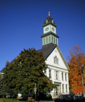
Coudersport, Pennsylvania — Borough — The Potter County Courthouse

 Coudersport, Pennsylvania
Coordinates: 41°46′26″N 78°01′07″W / 41.77389°N 78.01861°WCoordinates: 41°46′26″N 78°01′07″W / 41.77389°N 78.01861°W Country United States State Pennsylvania County Potter Settled 1807 Incorporated (borough) 1848 Government - Mayor Frederick "Wick" Furman Area - Total 5.7 sq mi (14.7 km2) Population (2000) - Total 2,650 - Density 467.2/sq mi (180.5/km2) Time zone Eastern (EST) - Summer (DST) EDT (UTC) Zip code 16915 Area code(s) 814 Website Coudersport Chamber of Commerce Coudersport is a borough in Potter County, Pennsylvania, 110 miles (180 km) east by south of Erie on the Allegheny River. The populations were these: 1,530 in 1890; 3,217 in 1900; and 3,100 in 1910. The population was 2,650 at the 2000 census. It is the county seat of Potter County.[1]
Contents
Geography
Coudersport is located at 41°46′26″N 78°1′7″W / 41.77389°N 78.01861°W (41.773903, -78.018559).[2]
According to the United States Census Bureau, the borough has a total area of 5.7 square miles (15 km2), all of it land.
Coudersport lies in a broad valley the joining of Allegheny and Mill Creek rivers. It is surrounded by the great hilltop plateaus of the Allegheny highlands. Highways enter north and south on Pennsylvania Route 44, the very old Jersey Shore (log road)Turnpike, and from west to east on U.S. Route 6, the "Grand Army of the Republic Highway", which had been long a major mid-east-states east-west corridor before Inter-State highways of late 1950s. The most noted hilltops, located here on this plateau, are Dutch Hill stretching southeastly, and Vader Hill stretching southwestly. The Allegheny river makes a quick turn at this point, going from North to West; for that reason these features are distinctly individual from afar in the broad turning valley, and rise 2400–2500 feet above sea-level.
Demographics
As of the census[3] of 2000, there were 2,650 people, 1,101 households, and 700 families residing in the borough. The population density was 467.2 people per square mile (180.5/km²). There were 1,189 housing units at an average density of 209.6 per square mile (81.0/km²). The racial makeup of the borough was 97.02% White, 0.49% African American, 0.08% Native American, 1.62% Asian, 0.19% from other races, and 0.60% from two or more races. Hispanic or Latino of any race were 0.49% of the population.
There were 1,101 households out of which 30.1% had children under the age of 18 living with them, 50.8% were married couples living together, 9.3% had a female householder with no husband present, and 36.4% were non-families. 32.0% of all households were made up of individuals and 13.1% had someone living alone who was 65 years of age or older. The average household size was 2.35 and the average family size was 3.00.
In the borough the population was spread out with 25.3% under the age of 18, 7.1% from 18 to 24, 27.5% from 25 to 44, 22.8% from 45 to 64, and 17.2% who were 65 years of age or older. The median age was 38 years. For every 100 females there were 94.1 males. For every 100 females age 18 and over, there were 89.7 males.
 Gazebo in Town Square behind Potter County Courthouse in Coudersport, PA
The median income for a household in the borough was $35,813, and the median income for a family was $44,053. Males had a median income of $32,288 versus $22,439 for females. The per capita income for the borough was $18,209. About 6.9% of families and 11.0% of the population were below the poverty line, including 12.6% of those under age 18 and 12.1% of those age 65 or over.
Notable facts
Coudersport is home to a Scottish Rite Consistory. With over 5000 members, Coudersport's Consistory is the largest consistory in the Scottish Rite by per capita membership.
Coudersport was the home of "Untouchable" Eliot Ness at the time of his death.
Located in the northern portion of Coudersport, is the Coudersport Area Recreation Park (CARP). This sports and recreation park was begun in the 1960s by a group of town leaders, which included Dr. William L. Mitchell, a local veterinarian. It currently has a football field with track & field capabilities, baseball and softball fields, basketball courts, picnic areas and hiking trails.
Coudersport has the former headquarters of Adelphia,[4] which went bankrupt after internal corruption earlier in the 2000s.[citation needed]
The fictional town of Farringdon, depicted in the Judy Bolton detective series by Margaret Sutton, is based on Coudersport, where Ms. Sutton grew up and attended school.[5] The school, town hall, and several recognizable residences are described in her books. Judy Bolton Days [1], an annual festival honoring the books of the late Margaret Sutton, is hosted each October by the local Chamber of Commerce.
Coudersport is hometown of indie folk rock group The Slant. Referred to by the band as "God's Country", The Slant's musical style is reminiscent of Coudersport's rural nature.
References
- ^ "Find a County". National Association of Counties. http://www.naco.org/Counties/Pages/FindACounty.aspx. Retrieved 2011-06-07.
- ^ "US Gazetteer files: 2010, 2000, and 1990". United States Census Bureau. 2011-02-12. http://www.census.gov/geo/www/gazetteer/gazette.html. Retrieved 2011-04-23.
- ^ "American FactFinder". United States Census Bureau. http://factfinder.census.gov. Retrieved 2008-01-31.
- ^ "Contact Information." Adelphia Media Services. Retrieved on April 29, 2010.
- ^ "Obituary: Margaret Sutton, 98; Wrote Mystery Series". New York Times. 2001-06-25. http://www.nytimes.com/2001/06/25/us/margaret-sutton-98-wrote-mystery-series.html. Retrieved 2009-06-22.
Municipalities and communities of Potter County, Pennsylvania County seat: Coudersport Boroughs Austin | Coudersport | Galeton | Oswayo | Shinglehouse | Ulysses

Townships Unincorporated
communityCounty seats of Pennsylvania Cities Allentown | Butler | Easton | Erie | Franklin | Greensburg | Harrisburg | Lancaster | Lebanon | Lock Haven | Meadville | New Castle | Philadelphia | Pittsburgh | Pottsville | Reading | Scranton | Sunbury | Uniontown | Warren | Washington | Wilkes-Barre | Williamsport | York
Boroughs Beaver | Bedford | Bellefonte | Bloomfield | Brookville | Carlisle | Chambersburg | Clarion | Clearfield | Coudersport | Danville | Doylestown | Ebensburg | Emporium | Gettysburg | Hollidaysburg | Honesdale | Huntingdon | Indiana | Jim Thorpe | Kittanning | Laporte | Lewisburg | Lewistown | McConnellsburg | Media | Mercer | Middleburg | Mifflintown | Milford | Montrose | Norristown | Ridgway | Smethport | Somerset | Stroudsburg | Tionesta | Towanda | Tunkhannock | Waynesburg | Wellsboro | West Chester
Town Categories:- County seats in Pennsylvania
- Populated places established in 1807
- Boroughs in Potter County, Pennsylvania


Wikimedia Foundation. 2010.