- Doylestown, Pennsylvania
-
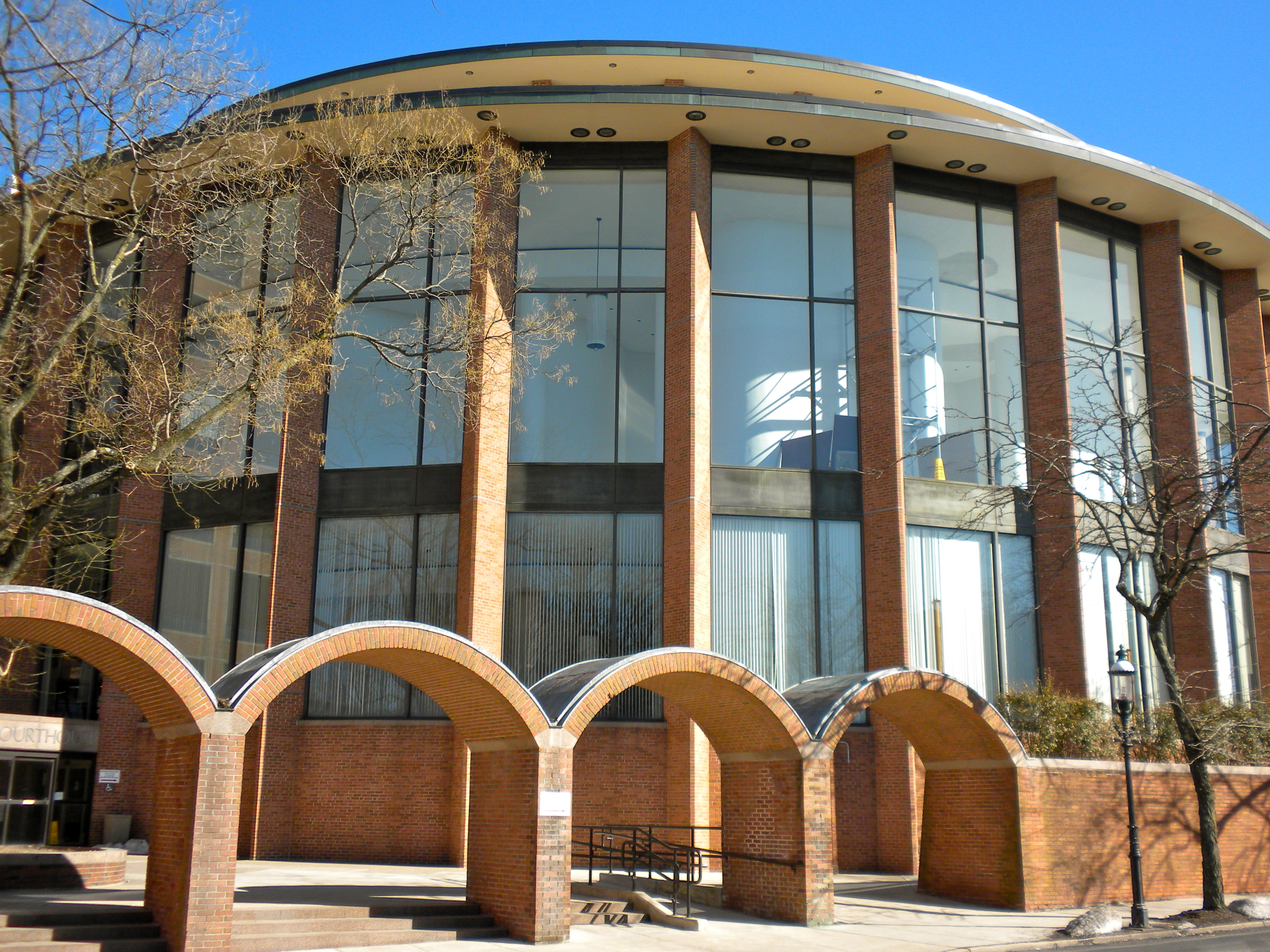
Borough of Doylestown Borough 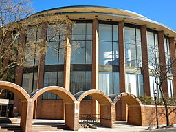 Bucks County Court House
 Seal
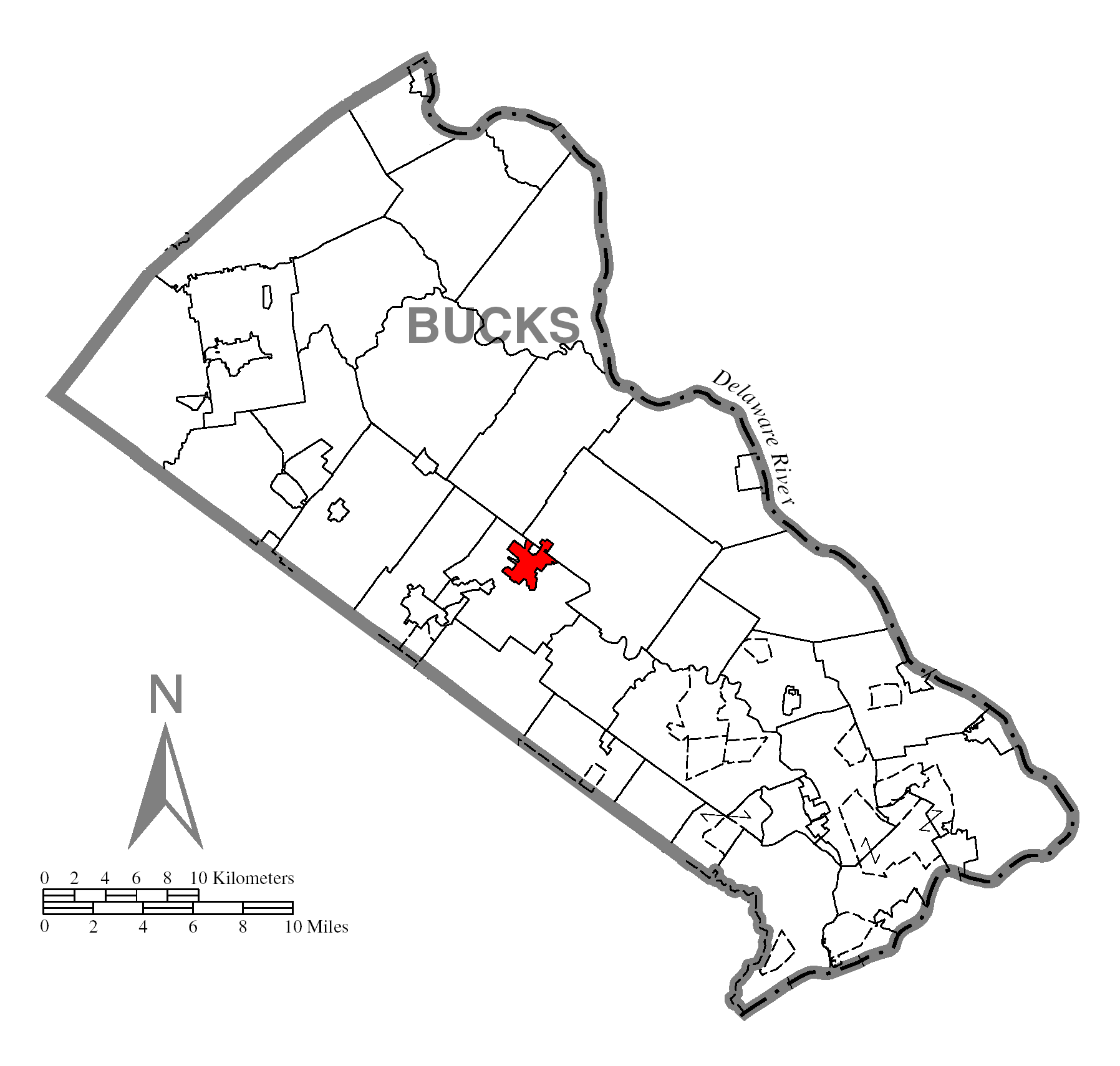
SealNamed for: William Doyle Country United States State Pennsylvania County Bucks Elevation 456 ft (139 m) Coordinates 40°18′46″N 75°07′44″W / 40.31278°N 75.12889°W Area 2.2 sq mi (5.7 km2) - land 2.2 sq mi (6 km2) - water 0.0 sq mi (0 km2), 0% Population 8,380 (2010) Density 3,822.5 / sq mi (1,475.9 / km2) Founded 1745 - Incorporated 1838 (Borough) Mayor Libby White Timezone EST (UTC-5) - summer (DST) EDT (UTC-4) ZIP codes 18901, 18902 Area code 215  Location of Doylestown in Bucks County
 Location of Doylestown in Pennsylvania
 Location of Pennsylvania in the United States
Website: http://www.doylestownborough.net Doylestown is a borough in Bucks County, Pennsylvania, 27 miles (43 km) north of Philadelphia. As of the 2010 census, the borough population was 8,380. The borough is the county seat of Bucks County.[1]
Contents
History
Doylestown's origins date to 1745 when William Doyle obtained a license to build a tavern on what is now the northwest corner of Main and State Street. Known for years as "William Doyle's Tavern", its strategic location at the intersection of the road linking Swede's Ford (Norristown) and Coryell's Ferry (New Hope) (now U.S. Route 202) and the road linking Philadelphia and Easton (now PA Route 611) - allowed the hamlet to blossom into a village. The first church was erected in 1815, followed by the establishment of a succession of congregations throughout the 19th century.
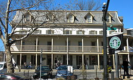 The Fountain House, at the corner of State and Main Streets, was built in 1758 and is on the National Register of Historic Places
During the first decade of the 19th century discontent developed with the location of the county seat for Bucks County because Newtown was not a central location. The more centrally located Doylestown became the county seat in 1813. An outgrowth of Doylestown's new courthouse was the development of "lawyers row", a collection of Federal-style offices. One positive consequence of early 19th century investment in the new county seat was organized fire protection, which began in 1825 with the Doylestown Fire Engine Company.
In 1838 the Borough of Doylestown was incorporated.
An electric telegraph station was built in 1846 and in 1856 a branch of the North Pennsylvania Railroad was completed to Doylestown. The first gas lights were introduced in 1854. Because of the town's relatively high elevation and a lack of strong water power, substantial industrial development never occurred and Doylestown evolved to have a professional and residential character.
During the mid-nineteenth century several large tracts located east of the courthouse area were subdivided into neighborhoods. The next significant wave of development occurred after the Civil War when the 30-acre (120,000 m2) Magill property to the southwest of the town's core was subdivided for residential lots.
In 1869 Doylestown established a water works. The first telephone line arrived in 1878, the same year that a new courthouse was erected. 1897 saw the first of several trolley lines connecting Doylestown with Willow Grove, Newtown and Easton beginning operation. A private sewer system and treatment plant was authorized in 1903. The Borough took over and expanded sewer service to about three-quarters of the town in 1921.
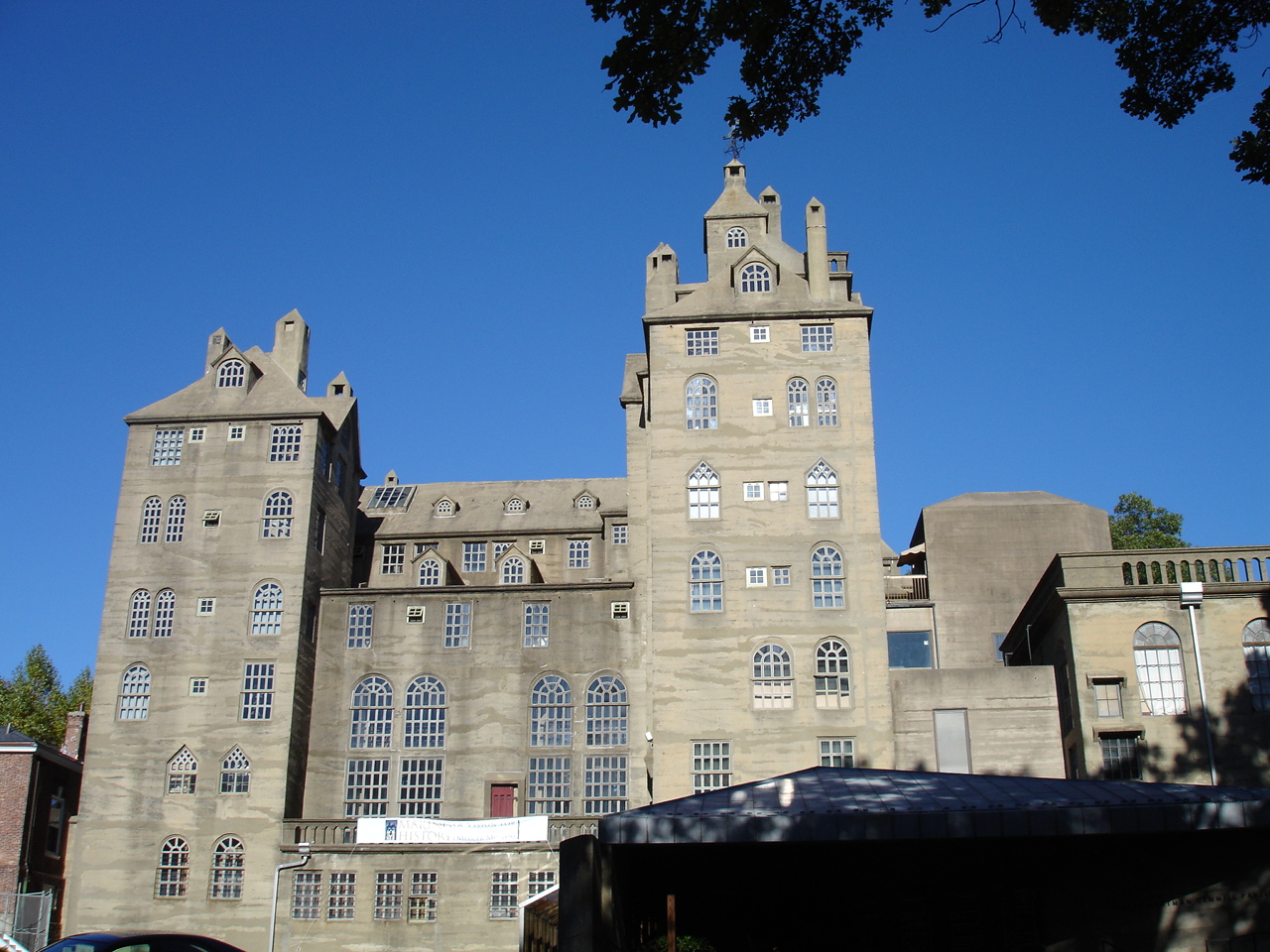
In the early 20th century, Doylestown became best known to the outside world through the "Tools of the Nation-Maker" museum of the Bucks County Historical Society. Henry Chapman Mercer constructed the reinforced poured concrete building in 1916 to house his collection of mechanical tools and utensils. Upon his death in 1930, Mercer also left his similarly constructed home Fonthill and adjacent "Moravian Pottery and Tile Works", to be operated as a museum. The home was left on the condition that his housekeeper be allowed to live there for the rest of her life. She lived there and gave tours until the mid nineteen-seventies.
 The County Theater in the Doylestown Historic District
By 1931, the advent of the automobile and improved highway service had put the last trolley line out of business and Doylestonians were forced to embrace the automobile as the primary means of travel within the region. The Great Depression took its toll, as many grand old houses constructed a century earlier fell into disrepair. During the 1930s, the Borough also expanded its land area to the north by admission of the tract known as the Doylestown Annex.
In the decade following World War II, Doylestown's business community boomed. During the 1940s, streets were paved for the first time in two decades and parking meters were introduced downtown in 1948. However, the Borough's post-war housing boom did not begin in earnest until the 1950s, when 550 new homes were built. This housing boom continued into the 1960s and 1970s, as more than 1,600 new homes were built during those decades and the Borough's population grew from 5,917 in 1960 to 8,717 in 1980.
As with many small towns across the country, the growth of the post war decades also brought a new competitor to the downtown business district—the shopping mall. By the 1960s, the toll could be seen in Doylestown by the numerous vacant buildings and dilapidated storefronts in the center of town. The Bucks County Redevelopment Authority responded with a federal urban renewal scheme that called for the demolition of 27 historic buildings. The local business community objected to such wholesale clearance and responded with its own plan called Operation '64—the Doylestown Plan for Self-Help Downtown Renewal. This private initiative was successful in saving Doylestown's old buildings and historic character, while improving business at the same time. One historic landmark that could not be saved was the 80-year-old courthouse and clock tower, which was replaced by the present county complex in the early 1960s.
By the end of the 1980s, the downtown business district was again showing the toll of massive new competition from the latest wave of suburban shopping centers, as well as the recession that hit hardest in the northeastern states. In response, the Borough Council established a volunteer group of civic-minded representatives from business organizations, government, and the residential community to begin to formulate plans for the downtown area in 1992. This effort resulted in streetscape improvements composed of cast iron street lamps and brick pavers, facade improvements and other beautification efforts, and the establishment of a Main Street Manager Program.
 Borough Hall of Doylestown
As the 1990s progressed, the downtown rebuilt itself largely by turning to an out-of-town audience. Doylestown had long been respected as a bucolic tourist destination. The gentry of Philadelphia and New York maintained country estates in the area—including figures of the Manhattan theater and literary scenes—often summered there. The Mercer Museum, Moravian Pottery and Tile Works, and the local National Shrine of Our Lady of Czestochowa brought a regular stream of short term visitors through the area as well. With charitable support, the art deco County Theater was restored and reopened showing arthouse fare, and a new main library and art museum were built around the ruins of the old stone jail, across the street from Mercer's castle. An official "resort town" designation exempted the area from liquor licence caps[citation needed] and empty commercial space began to fill with a dense and vibrant nighttime scene of bars and restaurants.
This development goes hand in hand with the broader development of the region; as the Philadelphia metropolitan area expanded from southern into central Bucks County, the fields and farms of the communities around Doylestown quickly began to sprout housing developments. This development brought thousands of people to the area, but the neighborhoods created often lacked longstanding institutions or discernible centers. Doylestown, more centrally located than Delaware River border town, New Hope, PA, which had traditionally served this function, was able to position itself as the regional center of culture and nightlife.
Personalities
Doylestown is known for being the home of author James A. Michener, architect and archaeologist Henry Chapman Mercer, lyricist and playwright Oscar Hammerstein II, nobel-prize winning author Pearl S. Buck, anthropologist Margaret Mead, and pop-rock star Pink. Other Doylestown notables include:
- Alecia Beth Moore (better known as Pink), singer/performer
- Kristen Alderson and Eddie Alderson, sibling actors
- Stefan Avalos, motion picture director
- Bill Bloom, Double Dutch Bus Composer
- Władysław Bortnowski, Polish general
- Christian Bauman, novelist and NPR commentator
- Michael T. Burke Jr. Former rogue Nasdaq trader, alcoholic, psychotic
- The band Circa Survive, fronted by Anthony Green
- Alan Campbell, actor and author
- Caroline Doty, a guard on the UConn Huskies Women's Basketball team
- David Gordon, classical tenor
- Justin Guarini, American Idol runner-up
- Matthew Clark, actor, founder of Knowledge Factory and King Man Productions
- Moss Hart, writer
- Doug Katsaros (musician)
- George S. Kaufman, pioneering figure in American musical theater
- Irene Molloy, singer/actress
- Kevin Nalty, YouTube personality
- Dorothy Parker, author
- S. J. Perelman, humorist
- Charles Sheeler, artist
- rock band Sinch
- Dodie Smith, author
- Timothy Stack, actor
- Stephen Susco, motion picture screenwriter
- Jean Toomer, author
- Erin Torpey, soap opera star
- Carla Ventresca, cartoonist
- Foster Winans, journalist, author, and ghostwriter
- Scott Green, NFL referee
- Dominic "Fro" Tibberino AMA Motocross Racer
- Kirk Bjornsgaard, Journalist, Author and Drummer
- Annie Haslam, Resident, Singer Songwriter Artist
- Joseph West, VP Projects Jacobs Engineering
Molly Ephraim, actress
Culture
 Mercer Museum
Doylestown Borough is home to three structures designed and built by Henry Chapman Mercer. The Mercer Museum, a structure built in poured concrete, is the home to Mercer's collection of early American artifacts. It also houses a collection known as "Tools of the Nation Maker"¹, and is one of the most important collections of its kind in the world. The Bucks County Historical Society also maintains the Spruance Library, a research library, adjoining the museum. Fonthill (also known as "Mercer's Castle") was Mercer's home and houses his collection of artifacts from around the world. The Moravian Pottery and Tile Works is an operational facility utilizing the tools and techniques used by Pennsylvania German potters in the 18th and 19th centuries.
The former prison, across the street from the Mercer Museum, has been converted into the James A. Michener Art Museum. The borough also boasts a small music conservatory, writers' and artists' organizations and other cultural activities.
Doylestown is also located near the Polish-American Roman Catholic shrine known as the National Shrine of Our Lady of Czestochowa, which houses a painting of the Black Madonna of Częstochowa, Poland.
The Fountain House, a historic building, is located in Doylestown Borough.
Education
Doylestown borough is the location of several educational facilities of the Central Bucks School District. The Borough contains two elementary schools (Doyle Elementary and Linden Elementary) , one middle school (Lenape Middle School) and one high school (Central Bucks West). Bucks County's regional educational service agency, Bucks County Intermediate Unit #22, is also located in the borough.
Doylestown Township, which is adjacent to the borough, contains Paul W. Kutz Elementary and also the campus of Delaware Valley College, which is still primarily known as an agricultural and science school.
Geography
Doylestown is located at 40°18′46″N 75°7′44″W / 40.31278°N 75.12889°W (40.312756, -75.128799).[2] According to the United States Census Bureau, the borough has a total area of 2.2 square miles (5.7 km2), all of it land.
Climate
Doylestown experiences an oceanic climate (Köppen climate classification Cfb). However, it barely misses the criteria for a humid subtropical climate (Köppen climate classification Cfa) by .1°F, but for all intents and purposes may be classified as the latter for the sake of continuity with the surrounding areas. Doylestown also lies near the convergence point into the humid continental climate region as the closest city with the latter, Easton, Pennsylvania, is only 33 mi (53 km) to the north.
Climate data for Doylestown Month Jan Feb Mar Apr May Jun Jul Aug Sep Oct Nov Dec Year Average high °F (°C) 39
(4)43
(6)52
(11)63
(17)74
(23)82
(28)87
(31)85
(29)77
(25)66
(19)55
(13)44
(7)64 Average low °F (°C) 24
(−4)25
(−4)33
(1)42
(6)52
(11)61
(16)66
(19)65
(18)57
(14)45
(7)37
(3)29
(−2)45 Precipitation inches (mm) 3.94
(100.1)2.87
(72.9)4.24
(107.7)3.85
(97.8)4.81
(122.2)3.61
(91.7)4.72
(119.9)4.34
(110.2)4.66
(118.4)3.35
(85.1)3.74
(95)3.80
(96.5)47.93
(1,217.4)Source: Weather Channel [3] Demographics
Historical populations Census Pop. %± 1930 4,577 — 1940 4,976 8.7% 1950 5,262 5.7% 1960 5,917 12.4% 1970 8,270 39.8% 1980 8,717 5.4% 1990 8,575 −1.6% 2000 8,227 −4.1% 2010 8,380 1.9% www.dvrpc.org/data/databull/rdb/db82/appedixa.xls As of the census[4] of 2000, there were 8,227 people, 3,952 households, and 1,908 families residing in the borough. The population density was 3,822.5 people per square mile (1,477.4/km²). There were 4,055 housing units at an average density of 1,884.1 per square mile (728.2/km²). The racial makeup of the borough was 95.24% White, 0.30% African American, 0.11% Native American, 1.42% Asian, 0.07% Pacific Islander, 0.43% from other races, and 0.63% from two or more races. Hispanic or Latino of any race were 2.20% of the population
There were 3,952 households out of which 19.0% had children under the age of 18 living with them, 39.0% were married couples living together, 7.2% had a female householder with no husband present, and 51.7% were non-families. 44.4% of all households were made up of individuals and 22.8% had someone living alone who was 65 years of age or older. The average household size was 1.98 and the average family size was 2.82.
In the borough the population was spread out with 16.5% under the age of 18, 5.7% from 18 to 24, 28.8% from 25 to 44, 23.5% from 45 to 64, and 25.4% who were 65 years of age or older. The median age was 44 years. For every 100 females there were 79.3 males. For every 100 females age 18 and over, there were 75.7 males.
The median income for a household in the borough was $46,148, and the median income for a family was $71,988. Males had a median income of $48,553 versus $31,703 for females. The per capita income for the borough was $32,249. About 2.5% of families and 4.4% of the population were below the poverty line, including 1.7% of those under age 18 and 9.6% of those age 65 or over.
Transportation
Train
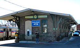 Doylestown SEPTA train station
Doylestown is connected to Philadelphia and many places between, by SEPTA's Lansdale/Doylestown Line of Regional Rail. Doylestown Station is the last stop.
Bus
Doylestown is served by SEPTA's route 55 bus, which heads south to Warrington, Willow Grove, Abington, and finally, the Olney Transportation Center in Philadelphia. Locally, Doylestown is served by small public transportation system called the Doylestown DART (Doylestown Area Regional Transit). Not to be confused with DART First State buses, Doylestown DART is a service of the Bucks County Transportation Management Association.[5] Doylestown DART consists (as of March, 2006) of a single bus route. Often used by the elderly, it travels to various destinations in Doylestown, including department stores, pharmacies and restaurants. Doylestown is also connected to towns in New Jersey and New York City by Trans-Bridge Lines.[6]
In popular culture
Doylestown is mentioned in Carbon Creek, an episode of Star Trek: Enterprise, as the site of a minor league baseball game attended in 1957 by two of the episode's characters.
Doylestown is the location of M. Night Shyamalan's 2002 film "Signs". The location of the film is cited as "Bucks County, PA" in the film. Filming was done in a corn field that forms part of the campus of Delaware Valley College.
King Man Productions' "Revenge of the Don" was filmed here in 2009 and premiered at the 2009 British Film Festival in Redondo Beach, California that same year.
Points of interest
- Delaware Valley College
- Fonthill Museum
- Henry Schmieder Arboretum
- James A. Michener Art Museum
- Mercer Museum
- Moravian Pottery and Tile Works
- National Shrine of Our Lady of Czestochowa
- Peace Valley Park
- Pearl S. Buck House
- Ringing Rocks Park
References
- ^ "Find a County". National Association of Counties. http://www.naco.org/Counties/Pages/FindACounty.aspx. Retrieved 2011-06-07.
- ^ "US Gazetteer files: 2010, 2000, and 1990". United States Census Bureau. 2011-02-12. http://www.census.gov/geo/www/gazetteer/gazette.html. Retrieved 2011-04-23.
- ^ Average weather for Doylestown Weather Channel Retrieved 2008-05-12
- ^ "American FactFinder". United States Census Bureau. http://factfinder.census.gov. Retrieved 2008-01-31.
- ^ Doylestown DART!
- ^ http://www.transbridgelines.com/
¹ "Ancient Carpenter's Tools: Illustrated and Explained, Together with the Implements of the Lumbermen, Joiner and Cabinet-Maker in use in the 18th Century", Henry Chapman Mercer, Bucks County Historical Society, 1929, ISBN 0-486-40958-9 page viii.
External links
County seats of Pennsylvania Cities Allentown | Butler | Easton | Erie | Franklin | Greensburg | Harrisburg | Lancaster | Lebanon | Lock Haven | Meadville | New Castle | Philadelphia | Pittsburgh | Pottsville | Reading | Scranton | Sunbury | Uniontown | Warren | Washington | Wilkes-Barre | Williamsport | York
Boroughs Beaver | Bedford | Bellefonte | Bloomfield | Brookville | Carlisle | Chambersburg | Clarion | Clearfield | Coudersport | Danville | Doylestown | Ebensburg | Emporium | Gettysburg | Hollidaysburg | Honesdale | Huntingdon | Indiana | Jim Thorpe | Kittanning | Laporte | Lewisburg | Lewistown | McConnellsburg | Media | Mercer | Middleburg | Mifflintown | Milford | Montrose | Norristown | Ridgway | Smethport | Somerset | Stroudsburg | Tionesta | Towanda | Tunkhannock | Waynesburg | Wellsboro | West Chester
Town Categories:- County seats in Pennsylvania
- Populated places established in 1745
- Boroughs in Bucks County, Pennsylvania


Wikimedia Foundation. 2010.