- Chalfont, Pennsylvania
-
Borough of Chalfont home rule municipality 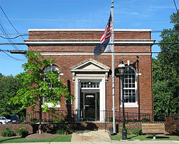 Borough building
 Seal
SealCountry United States State Pennsylvania County Bucks Elevation 272 ft (82.9 m) Coordinates 40°17′23″N 75°12′37″W / 40.28972°N 75.21028°W Area 1.6 sq mi (4.1 km2) - land 1.6 sq mi (4 km2) - water 0.0 sq mi (0 km2), 0% Population 4,009 (2010) Density 2,365.8 / sq mi (913.4 / km2) Mayor Marilyn J. Becker Timezone EST (UTC-5) - summer (DST) EDT (UTC-4) Area code 215 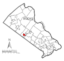 Location of Chalfont in Bucks County
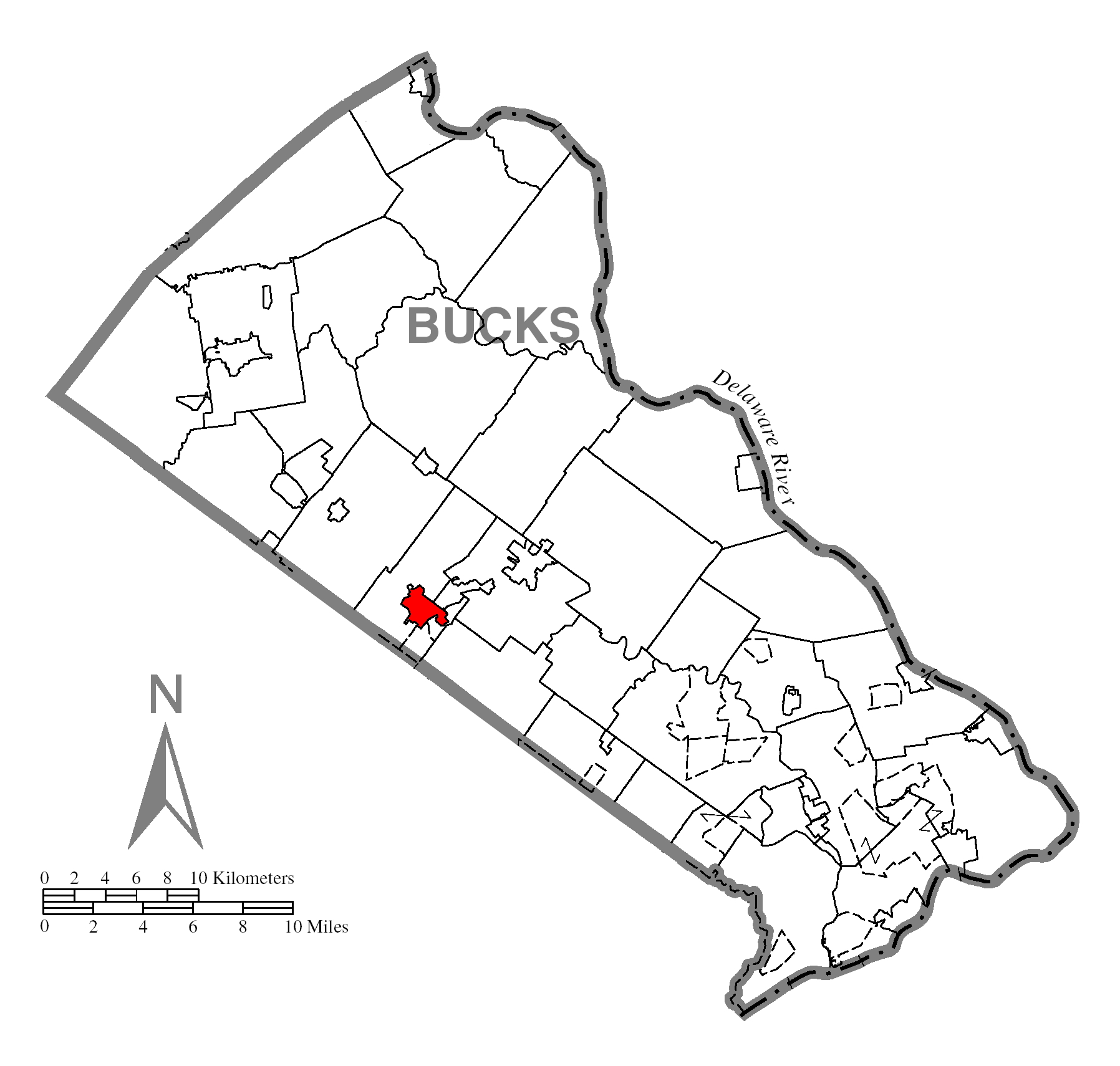
 Location of Chalfont in Pennsylvania
 Location of Pennsylvania in the United States
Website: http://www.chalfont.govoffice.com Chalfont is a home rule municipality located in Bucks County, Pennsylvania, United States. The population was 4,009 at the 2010 census.
Chalfont is named after Chalfont St Giles in Buckinghamshire, England. Chalfont was the home of William Penn's first wife, and William Penn is buried at Jordans Quaker Meeting House near Chalfont St Giles.
The Chalfont Historic District is listed on the National Register of Historic Places and contains many American colonial and Victorian-style houses. Several of these are former residences which are currently occupied by businesses and are concentrated near the intersection of Butler Avenue (U.S. Route 202) and North Main Street (Pennsylvania Route 152) and extend along North Main Street. Many residents love their hometown and feel the pride of being in what is considered one of "the best of all Buck's towns."
Contents
Geography
Chalfont is located at 40°17′23″N 75°12′37″W / 40.28972°N 75.21028°W (40.289739, −75.210241)[1].
According to the United States Census Bureau, the borough has a total area of 1.6 square miles (4.3 km²), all of it land. The center of town is relatively flat. As you travel North through town, you will come across various hills, forests, and farm land. Located about two miles outside of the center of town is Lake Galena, a man-made lake that was once the location of a lead mine. This park, known as Peace Valley, provides the residents of Chalfont and surrounding towns a place to bicycle, jog, fish, canoe, and go sail boating. The center of town, as well as the Western and Eastern areas of town, are very residential and developed. There are many sidewalks throughout town to utilize as well. However, traffic along 202 going through town can be notoriously bad, especially around rush hour. A train station in town provides a way around this traffic, with service to and from Philadelphia and surrounding areas.
Demographics
Historical populations Census Pop. %± 1930 550 — 1940 670 21.8% 1950 828 23.6% 1960 1,410 70.3% 1970 2,366 67.8% 1980 2,802 18.4% 1990 3,069 9.5% 2000 3,900 27.1% 2010 4,009 2.8% www.dvrpc.org/data/databull/rdb/db82/appedixa.xls As of the census[2] of 2000, there were 3,977 people, 1,382 households, and 1,039 families residing in the borough. The population density was 2,365.8 people per square mile (912.6/km²). There were 1,404 housing units at an average density of 851.7 per square mile (328.5/km²). The racial makeup of the borough was 95.56% White, 1.15% African American, 0.08% Native American, 1.49% Asian, 0.05% from other races, and 0.77% from two or more races. Hispanic or Latino of any race were 1.25% of the population.
There were 1,382 households out of which 40.1% had children under the age of 18 living with them, 66.2% were married couples living together, 6.9% had a female householder with no husband present, and 24.8% were non-families. 19.6% of all households were made up of individuals and 4.8% had someone living alone who was 65 years of age or older. The average household size was 2.78 and the average family size was 3.25.
In the borough the population was spread out with 29.1% under the age of 18, 5.5% from 18 to 24, 34.9% from 25 to 44, 21.9% from 45 to 64, and 8.6% who were 65 years of age or older. The median age was 36 years. For every 100 females there were 96.9 males. For every 100 females age 18 and over, there were 94.4 males.
The median income for a household in the borough was $63,491, and the median income for a family was $70,592. Males had a median income of $51,139 versus $30,842 for females. The per capita income for the borough was $26,248. About 1.1% of families and 4.1% of the population were below the poverty line, including 1.4% of those under age 18 and 3.2% of those age 65 or over.
Downtown Chalfont
Downtown Chalfont is a quaint area with many Victorian buildings. This formerly residential area, is now home to many local businesses, restaurants and funeral homes.
The Historic District
The Historic District of Chalfont is not only beautiful, but as the name implies historical. Though some residents consider it an active part of the Downtown District, others prefer to consider this quiet section of town as its own special part of the community. The Historic district mainly includes St. James Church, built in 1857, and despite the fact that the church building is vacant, it still gives the aura of a beautiful building. One would also view a number of Victorian and Second Empire style homes of various colors. Some of these homes have been converted into businesses, yet they remain as scenic as when they were private residences. Also a part of the town is the local Chalfont train station, part of the Lansdale/Doylestown Line train line and the Fire-House, constructed in the early 20th century. The tree-lined streets look especially wonderful in the fall when all the leaves change colors.
Churches
Chalfont welcomes members of all religious beliefs but the churches of the town represent only the Christian faith. Churches include the historic St. James Lutheran Church, which has since been vacant since a split in the parish. It was organized in 1857 and grew in size in the 1930s. There is also the much newer Chalfont United Methodist Church. The original Methodist church was built in 1896, however as the faithful community grew, improvements were made to the building and later in 1950s and '60s, the Church moved to various buildings. The Catholic Community is represented in the beautiful St. Jude Roman Catholic Church, located on 202. The church building,itself, was built during the latter half of the 20th century and the extensive grounds also include a school for grades Pre-K to 8th grade. In 1982, a fire burnt down the church due to negligence with the candles. Since then, a new church has been built as well as an addition to the school. Also on the grounds is the original farmhouse, which was converted into a rectory by Father Gregg and has been put to various other uses over the years since a new rectory was built. However, the building has been named The Father Gregg Center in his honor. The grounds also feature the school, rectory, playground, and playing fields.
History
Chalfont is rich in history. Originally, the Lenape Indians dwelt in present day Chalfont. In 1683, William Penn signed a treaty with the local chief and parceled the land to the Free Society of Traders. In 1720, Simon Butler bought over 150 acres of land, including the "Village of Chalfont." After the construction of his home and mill, Butler bought more than 400 more acres of land. Butler was a giant historical figure who acted as a legal and economic powerhouse in the area. After his death, the land was parceled to a number of people. Since then and 1901, Chalfont has been named a number of things including Butler's Mill, Kungle's Tavern, Barndtsville, and Whitehallville. For many years, the most important building in the area was the tavern and public house, which has burnt down many times and now stands as Borghi's Restaurant. During the Victorian era, a train-station was built which helped the community grow and brought about the construction of the many Victorian houses.
Chalfont had always been well known for its ideal location for picnics since George Eckhart opened a grove in 1835. However, one of the most momentous occasions in Chalfont's history would be the opening of Forest Park in 1885. Forest park started out as a small picnic ground where music could be played. The appearance of the train station in Chalfont assured the park's success. However, as the park grew it became a small amusement park where local people could enjoy rides, a large swimming pool built in the '30s, music (including string bands in the '40s) and as the hosting ground for many company picnics. The park closed its doors forever in 1968.[3]
References
- ^ "US Gazetteer files: 2010, 2000, and 1990". United States Census Bureau. 2011-02-12. http://www.census.gov/geo/www/gazetteer/gazette.html. Retrieved 2011-04-23.
- ^ "American FactFinder". United States Census Bureau. http://factfinder.census.gov. Retrieved 2008-01-31.
- ^ A History of Chalftont (1977) by the Chalfont Borough Bicentennial Committee
External links
Categories:- Home Rule Municipalities in Pennsylvania
- Populated places established in 1765
- Populated places in Bucks County, Pennsylvania


Wikimedia Foundation. 2010.