- Stroudsburg, Pennsylvania
Geobox Borough
name = Borough of Stroudsburg
native_name =
other_name =
other_name1 =
category =
image_size =
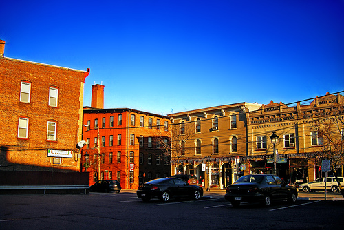
image_caption = Downtown Stroudsburg
flag_size =
symbol =
symbol_size =
country = United States
state = Pennsylvania
region = Monroe
region_type = County
district =
area_imperial = 1.8
area_land_imperial = 1.76
area_water_imperial = 0.04
area_water_percentage = auto
area_percentage_round = 2
area_round = 1
location =
lat_d = 40
lat_m = 59
lat_s = 09
lat_NS = N
long_d = 75
long_m = 11
long_s = 43
long_EW = W
elevation_imperial = 509
elevation_round = 1
population_as_of = 2000
population = 5756
population_density_imperial = 3245.1
population_density_round = 1
established_type =
established =
mayor = Charlie Baughman
timezone = EST
utc_offset = -5
timezone_DST = EDT
utc_offset_DST = -4
postal_code_type =ZIP Code
postal_code = 18360
area_code = 570
area_code_type =
code2_type =
code2 =
free_type =
free =
free1_type =
free1 =

map_caption = Location of Stroudsburg in Monroe County
map1 = Pennsylvania Locator Map.png
map1_locator = Pennsylvania
map2 = Map of USA PA.svg
map2_caption = Location of Pennsylvania in the United States
website = http://www.borough.stroudsburg.pa.usStroudsburg is a borough in Monroe County,
Pennsylvania ,United States . It is located in the Poconos region of the state, approximately five miles (8 km) from theDelaware Water Gap , at the confluence of the Brodhead and Pocono creeks. It is thecounty seat of Monroe County.GR|6In 1900, 3,450 people inhabited Stroudsburg; in 1910, 4,379; and in 1940, 6,186 people lived here. The population was 5,756 at the 2000 census.
Stroudsburg estimated population for 2005 is 6,264 with an increase of 508 people. It is estimated that eighy-four percent of the residents in Stroudsburg commute to work daily.
Geography
Stroudsburg is located at coor dms|40|59|9|N|75|11|43|W|city (40.985764, -75.195352).GR|1
According to the
United States Census Bureau , the borough has a total area of 1.8square mile s (4.7km² ).1.8 square miles (4.6 km²) of it is land and 0.04 square miles (0.1 km²) of it (1.67%) is water.Stroudsburg is located 30 miles north of Easton and 53 miles southeast of Scranton.
Stroudsburg's elevation is 500 feet above sea level.
Demographics
As of the
census GR|2 of 2000, there were 5,756 people, 2,422 households, and 1,237 families residing in the borough. Thepopulation density was 3,245.1 people per square mile (1,255.6/km²). There were 2,630 housing units at an average density of 1,482.7/sq mi (573.7/km²). The racial makeup of the borough was 86.61% White, 6.45% African American, 0.21% Native American, 1.89% Asian, 2.26% from other races, and 2.59% from two or more races. Hispanic or Latino of any race were 6.95% of the population.There were 2,422 households out of which 25.1% had children under the age of 18 living with them, 34.8% were married couples living together, 13.0% had a female householder with no husband present, and 48.9% were non-families. 34.8% of all households were made up of individuals and 16.2% had someone living alone who was 65 years of age or older. The average household size was 2.30 and the average family size was 2.98.
In the borough the population was spread out with 21.2% under the age of 18, 15.0% from 18 to 24, 28.3% from 25 to 44, 18.7% from 45 to 64, and 16.8% who were 65 years of age or older. The median age was 35 years. For every 100 females there were 86.8 males. For every 100 females age 18 and over, there were 83.2 males.
The median income for a household in the borough was $32,409, and the median income for a family was $47,500. Males had a median income of $31,952 versus $26,863 for females. The
per capita income for the borough was $18,965. About 9.6% of families and 19.3% of the population were below thepoverty line , including 20.2% of those under age 18 and 11.3% of those age 65 or over.Notable Current and Former Residents
G.E. Smith , musician, born in Stroudsburg, January 27, 1952.Bob Dorough , musician & composer famous for theSchoolhouse Rock! series is a resident.John Summerfield Staples ,Civil War Union soldier, paid "stand-in" for PresidentAbraham Lincoln Alexander Mitchell Palmer , attorney general of the United States from 1919 to 1921.Public education
The Borough is served by the Stroudsburg Area School District.
Stroudsburg is in the Eastern Time ZoneArea Code: 18360
References
Wikimedia Foundation. 2010.