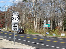
Pennsylvania Route 390

Pennsylvania Route 390

PA Route 390 marker

PA Route 390

Pennsylvania Route 191 at the southern terminus of the Route 390 concurrency in Paradise Township.
Route information
Maintained by PennDOT
Length: 25 mi[1] (40 km)
Existed: 1928 – present
Major junctions
South end: PA-940.svg PA 940 near Paradise Township.
  PA-191.svg PA 191 in Paradise Township.
PA-447.svg PA 447 in Barrett Township.
I-84.svg I 84 near Promised Land State Park
North end: PA-507.svg PA 507 in Tafton View
Location
Counties: Monroe, Pike
Highway system

Roads in Pennsylvania
Interstate • US • State • Legislative

PA 388 PA 391

Pennsylvania Route 390 is an 25-mile (40 km) long state highway located in Monroe, and Pike counties in Pennsylvania. The southern terminus is at PA 940 near Paradise Township. The major routes that PA 390 joins are PA 191, PA 447, and I-84. The northern terminus is at PA 507 in Tafton View.

Along the route, PA 390 joins PA 191 for about 2.5 miles before the split in Mountainhome. North of PA 447 is Skytop, which then leads into the scenic part of the route. PA 390 passes Promised Land State Park, a small, but reasonable sized state park. Then, PA 390 passes the former Tanglewood Ski Area, now a winery and Italian restaurant.

References


Wikimedia Foundation. 2010.

Игры ⚽ Поможем написать курсовую

Look at other dictionaries:

  • Pennsylvania Route 191 — PA Route 191 Route information Maintained by Pe …   Wikipedia

  • Pennsylvania Route 940 — PA Route 940 Route information Maintained by PennDOT Length: 44 mi[1 …   Wikipedia

  • Pennsylvania Route 447 — Infobox road state=PA type=PA route=447 length mi=26.3 length round=0 length ref= [http://www.pahighways.com/state/PA401 450.html#PA447 Pennsylvania Highways Pennsylvania Route 447] ] established=1964 direction a=South starting terminus= junction …   Wikipedia

  • Pennsylvania Route 103 — PA Route 103 Route information Maintained by PennDOT Length: 31 mi[1 …   Wikipedia

  • Pennsylvania Route 507 — PA Route 507 Route information Maintained by PennDOT Length: 21 mi[1] …   Wikipedia

  • Pennsylvania Route 388 — PA Route 388 Route information Maintained by PennDOT Length: 8.4 mi[1] …   Wikipedia

  • National Register of Historic Places listings in Pike County, Pennsylvania — Location of Pike County in Pennsylvania This is a list of the National Register of Historic Places listings in Pike County, Pennsylvania. This is intended to be a complete list of the properties and districts on the National Register of Historic… …   Wikipedia

  • List of highways numbered 390 — The following highways are numbered 390: Canada Quebec Route 390 Japan Japan National Route 390 United States …   Wikipedia

  • Canadensis, Pennsylvania — Infobox Settlement official name = Village of Canadensis settlement type = Village nickname = motto = subdivision type = Country subdivision name = United States subdivision type1 = State subdivision name1 = Pennsylvania subdivision type2 =… …   Wikipedia

  • New York State Route 36 — NY 36 redirects here. NY 36 may also refer to New York s 36th congressional district. NYS Route 36 Map of New York with NY 36 highlighted in red …   Wikipedia

Share the article and excerpts

Direct link
Do a right-click on the link above
and select “Copy Link”