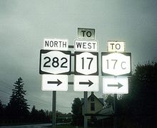
- New York State Route 282
-
NYS Route 282 Route information Maintained by NYSDOT Length: 3.48 mi[2] (5.60 km) Existed: 1930[1] – present Major junctions South end:  PA 187 at Nichols
 NY 17 in Nichols
North end:  NY 17C in Smithboro
Location Counties: Tioga Highway system Numbered highways in New York
Interstate • U.S. • N.Y. (former) • Reference • County←  NY 281
NY 283  →
→New York State Route 282 (NY 282) is a state highway in the Southern Tier of New York in the United States. This highway is a north–south roadway connecting NY 17C to the Pennsylvania state line, where it becomes Pennsylvania Route 187.
NY 282 is located entirely within Tioga County, beginning at its northern end, in the Town of Tioga, crossing the Susquehanna River, and passing through the Town of Nichols to Pennsylvania.
Contents
Route description
Route 282 begins at the state line, where Pennsylvania Route 187 left off. Route 282 heads to the north, passing fields, farms and a few residential homes along the way. The highway intersects a former routing of itself, which heads into a field nearby. Route 282 enters the town of Nichols, where it intersects with County Route 505. In Nichols, Route 282 turns to the west at East River Road, now paralleling the Southern Tier Expressway (I-86/NY 17). The two roads interchange, the first time eastbound, and after a turn to the north with West River Road, the westbound exit. Route 282 heads out of Nichols, via a bridge over a river. Route 282 terminates at NY 17C soon after.[3]
History
Route 282 was assigned to its current alignment as part of the 1930 renumbering.[1]
Major intersections
The entire route is in Tioga County.
Location Mile[2] Destinations Notes Town of Nichols 0.00  PA 187
Continuation into Pennsylvania Village of Nichols 1.91  CR 6
CR 6Formerly part of NY 283 Town of Nichols 2.61  NY 17 east
Exit 62 (NY 17)  CR 4
CR 4Formerly part of NY 283 2.96  NY 17 west
Exit 62 (NY 17) Smithboro 3.48  NY 17C
1.000 mi = 1.609 km; 1.000 km = 0.621 mi References
- ^ a b Pennsylvania Department of Highways (1930) (PDF). Tourist Map of Pennsylvania (Map). ftp://ftp.dot.state.pa.us/public/pdf/BPR_pdf_files/Maps/Statewide/Historic_OTMs/1930fr.pdf. Retrieved March 26, 2008.
- ^ a b "2008 Traffic Volume Report for New York State" (PDF). New York State Department of Transportation. June 16, 2009. p. 205. https://www.nysdot.gov/divisions/engineering/technical-services/hds-respository/NYSDOT%20TVR%202008%20by%20Route.pdf. Retrieved February 1, 2010.
- ^ Google, Inc. Google Maps – overview map of NY 282 (Map). Cartography by Google, Inc. http://maps.google.com/maps?sourceid=navclient&ie=UTF-8&rlz=1T4ADBF_enUS232US232&q=from:+RT-282+%4041.998410,+-76.349880+to:+RT-282+%4042.033772,+-76.383524&um=1&sa=N&tab=wl. Retrieved March 26, 2008.
External links
Categories:- State highways in New York
- Transportation in Tioga County, New York
Wikimedia Foundation. 2010.


