- New York State Route 266
-
NYS Route 266
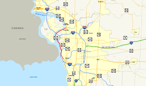
Map of Buffalo with NY 266 highlighted in redRoute information Maintained by NYSDOT and the cities of Buffalo and Tonawanda Length: 11.13 mi[3] (17.91 km) Existed: ca. 1935[1][2] – present Major junctions South end: 
 I-190 / Thruway in Buffalo
North end:  NY 265 in Tonawanda
Location Counties: Erie Highway system Numbered highways in New York
Interstate • U.S. • N.Y. (former) • Reference • County← NY 265NY 268  →
→New York State Route 266 (NY 266) is a state highway in Erie County, New York, in the United States. It runs along the Niagara River from the city of Buffalo to the city of North Tonawanda. The southern terminus of the route is at the ramps leading to Interstate 190 exit 8 in Buffalo. Its northern terminus is at an intersection with NY 265 just south of North Tonawanda in the city of Tonawanda.
Contents
Route description

Route 266 starts near the Peace Bridge in Buffalo as Niagara Street. It continues upriver, closely paralleling the New York State Thruway's Niagara Section (Interstate 190). After the Scajaquada Expressway (NY 198), NY 265 forks off to the northeast.
Leaving the city, entering an industrial area of the Town of Tonawanda, it becomes River Road. Shortly afterwards, the short western connector end of Sheridan Drive, NY 325, splits off in the same direction. After that it crosses over I-190 and stays with the river past the tank farm. It crosses under the interstate, this time with an exit, just on the mainland side of the South Grand Island Bridge. Finally the river takes it into the city of Tonawanda, where it ends at another junction with 265 a short distance south of Tonawanda Creek and the Erie Canal, which share the water channel that forms the border between Tonawanda, Erie County and North Tonawanda, Niagara County.
History
All of modern NY 266 was originally designated as part of NY 384 in the 1930 renumbering of state highways in New York. NY 384 began at Main Street (NY 5) in Buffalo and followed Niagara Street and River Road north to the city of Tonawanda, where it turned north onto modern NY 265 and proceeded across the Erie Canal into North Tonawanda.[4] Ca. 1935, NY 266 was assigned to the portion of modern NY 384 between Sheridan Drive (NY 324) in the town of Tonawanda and River Road (then-NY 384) in North Tonawanda.[1][2] NY 384 was realigned by the following year to follow Delaware Avenue between downtown Buffalo and North Tonawanda. The change supplanted NY 266, which was reassigned to the portion of NY 384's original, riverside routing south of NY 265 in the city of Tonawanda.[5] The south end of the route was shifted three blocks west to Niagara Square in the 1960s after NY 5 was realigned through downtown Buffalo to serve the square.[6][7] NY 266 was truncated again in the early 1970s to begin at the newly-constructed ramps leading to Interstate 190 exit 8.[8][9]
Major intersections
The entire route is in Erie County.
Location Mile[3] Destinations Notes Buffalo 0.00 I-190 / ThruwayExit 8 (I-190 / Thruway) 2.78  NY 198 / NY 265
Southern terminus of NY 265 I-190 / Thruway south via Hamilton StreetExit 12 (I-190 / Thruway) 3.69 I-190 / Thruway south via Hertel AvenueExit 13 (I-190 / Thruway) 4.00 I-190 / ThruwayExit 14 (I-190 / Thruway) Town of Tonawanda 5.58  I-190 / Thruway south / NY 325
Exit 15 (I-190 / Thruway); southern terminus of NY 325 7.97  I-190 / Thruway / NY 324
Exit 17 (I-190 / Thruway) City of Tonawanda 11.13 NY 265Former western terminus of NY 356 1.000 mi = 1.609 km; 1.000 km = 0.621 mi References
- ^ a b Texas Oil Company (1934). Road Map of New York (Map). Cartography by Rand McNally and Company.
- ^ a b Sun Oil Company (1935). Road Map & Historical Guide – New York (Map). Cartography by Rand McNally and Company.
- ^ a b "2008 Traffic Data Report for New York State" (PDF). New York State Department of Transportation. June 16, 2009. pp. 281–282. https://www.nysdot.gov/divisions/engineering/technical-services/hds-respository/NYSDOT_Traffic_Data_Report_2008.pdf. Retrieved January 10, 2010.
- ^ Standard Oil Company of New York (1930). Road Map of New York (Map). Cartography by General Drafting.
- ^ Standard Oil Company (1936). New York (Map). Cartography by General Drafting.
- ^ Esso (1962). New York with Sight-Seeing Guide (Map). Cartography by General Drafting (1962 ed.).
- ^ Esso (1968). New York (Map). Cartography by General Drafting (1969–70 ed.).
- ^ State of New York Department of Transportation (January 1, 1970) (PDF). Official Description of Touring Routes in New York State. http://www.greaternyroads.info/pdfs/state70.pdf. Retrieved May 26, 2010.
- ^ Shell Oil Company (1973). New York (Map). Cartography by H.M. Gousha Company (1973 ed.).
External links
Categories:- State highways in New York
- Transportation in Buffalo, New York
- Transportation in Erie County, New York


Wikimedia Foundation. 2010.