- New York State Route 356
-
NYS Route 356
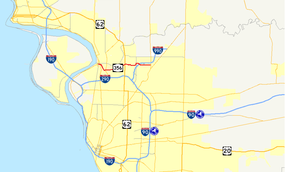
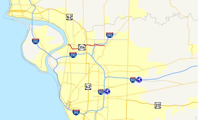
Map of the Buffalo – Niagara Falls area with the pre-1980 routing of NY 356 highlighted in redRoute information Maintained by NYSDOT Length: 2.77 mi[3][4][a] (4.46 km) Existed: 1930[1] – January 7, 1988[2] Major junctions West end:  US 62 on Tonawanda–Amherst town line
East end:  NY 270 in Amherst
Location Counties: Erie Highway system Numbered highways in New York
Interstate • U.S. • N.Y. (former) • Reference • County←  NY 355
NY 357  →
→New York State Route 356 (NY 356) was an east–west state highway in Erie County, New York, United States. The final western terminus of the route was at an intersection with U.S. Route 62 on the Tonawanda–Amherst town line. Its eastern terminus was at a junction with NY 270 in the Amherst hamlet of Getzville. When NY 356 was first assigned in the 1930 renumbering of state highways in New York, it began at NY 384 in the city of Tonawanda. It was truncated to US 62 in 1980 and removed entirely on January 7, 1988. The former routing of NY 356 east of the Tonawanda city limits is now maintained by Erie County.
Contents
Route description
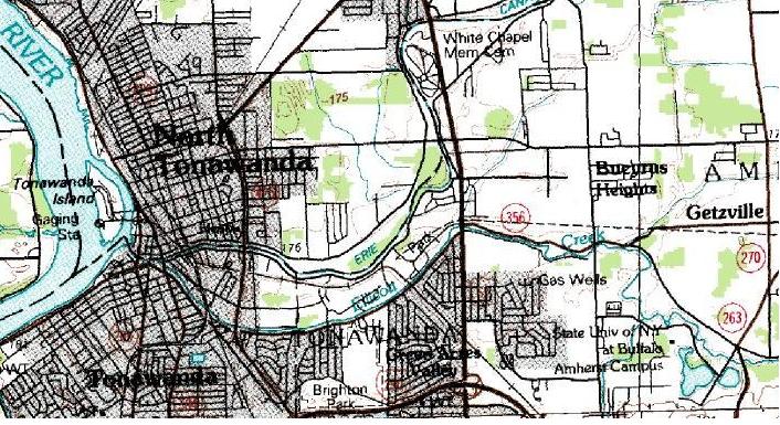
 Topographic map of NY 356's former routing
NY 356 began at an intersection with U.S. Route 62 on the Tonawanda–Amherst town line. It headed eastward on North Ellicott Creek Road, running along the northern edge of Ellicott Creek as it headed through the town of Amherst. NY 356 met Sweet Home Road, a local highway leading to the main campus of SUNY Buffalo, and crossed over Ellicott Creek shortly afterward. Not far to the northeast of the creek, North Ellicott Creek Road merged into Dodge Road. NY 356 continued east on Dodge Road to the hamlet of Getzville, where it ended at a junction with NY 270.[5]
History
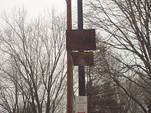 An old NY 356 shield in Tonawanda.
NY 356 was assigned as part of the 1930 renumbering of state highways in New York. It began at NY 384 (now NY 266) in the city of Tonawanda and ended at NY 270 in the hamlet of Getzville.[1] On April 1, 1980, ownership and maintenance of NY 356 between the Tonawanda city line and U.S. Route 62 was transferred from the state of New York to Erie County as part of a highway maintenance swap between the two levels of government.[6] As a result, NY 356 was truncated eastward to begin at US 62.[5][7] The NY 356 designation was removed entirely on January 7, 1988.[2] The former routing of NY 356 is now maintained by Erie County as County Route 580 from the Tonawanda city line to US 62, County Route 232 between US 62 and Sweet Home Road, and County Route 294 (North Forest Road) and County Route 45 (Dodge Road) east of Ellicott Creek. The portion of NY 356's former routing that traversed Ellicott Creek was dismantled as part of Interstate 990's construction.[8]
Major intersections
The entire route was in Erie County.
Location Mile[3][4] Destinations Notes Tonawanda–Amherst town line 0.00 US 62Amherst 1.27 Sweet Home Road (NY 952T) To SUNY Buffalo 2.77[a] NY 270Hamlet of Getzville 1.000 mi = 1.609 km; 1.000 km = 0.621 mi Notes
- 1. ^ Approximate length; a 700-foot (210 m) section of NY 356's former routing near modern I-990 no longer exists.
References
- ^ a b Standard Oil Company of New York (1930). Road Map of New York (Map). Cartography by General Drafting.
- ^ a b New York State Department of Transportation (January 2009) (PDF). Official Description of Highway Touring Routes, Bicycling Touring Routes, Scenic Byways, & Commemorative/Memorial Designations in New York State. https://www.nysdot.gov/divisions/operating/oom/transportation-systems/repository/2009%20tour-bk.pdf. Retrieved June 27, 2009.
- ^ a b Yahoo! Inc. Yahoo! Maps – overview map of former NY 356 west of modern I-990 (Map). Cartography by NAVTEQ. http://maps.yahoo.com/#mvt=m&lat=43.021893&lon=-78.798186&zoom=18&q1=43.025088%2C-78.822172&q2=43.022163%2C-78.799001&q3=43.022226%2C-78.794753. Retrieved June 27, 2009.
- ^ a b Yahoo! Inc. Yahoo! Maps – overview map of former NY 356 east of modern I-990 (Map). Cartography by NAVTEQ. http://maps.yahoo.com/#mvt=m&lat=43.023127&lon=-78.782819&zoom=17&q1=43.021817%2C-78.792346&q2=43.024218%2C-78.767841. Retrieved June 27, 2009.
- ^ a b Rand McNally (1985). New York (Map). ISBN 0-528-91040-X.
- ^ New York State Legislature. "New York State Highway Law § 341". http://public.leginfo.state.ny.us/menugetf.cgi?COMMONQUERY=LAWS. Retrieved June 27, 2009.
- ^ State of New York (1981). I Love New York Tourism Map (Map). Cartography by Rand McNally and Company.
- ^ New York State Department of Transportation (1996). Tonawanda Digital Raster Quadrangle (Map). 1:24,000. http://www.nysgis.state.ny.us/gisdata/quads/drg24/dotpreview/index.cfm?code=p8. Retrieved June 27, 2009.
External links
Categories:- Former state highways in New York
- Transportation in Erie County, New York


Wikimedia Foundation. 2010.