- U.S. Route 62 in New York
-
This article is about the section of U.S. Route 62 in New York. For the entire length of the highway, see U.S. Route 62.
U.S. Route 62

Map of New York with US 62 highlighted in redRoute information Maintained by NYSDOT, Erie County, and the cities of Buffalo and Lackawanna Length: 102.77 mi[3] (165.39 km) Existed: ca. 1932[1][2] – present Major junctions South end:  US 62 at Pennsylvania state line south of Jamestown
 I-86 / NY 17 in Poland
 NY 39 in Gowanda
 US 20 in Hamburg
 I-290 north of Buffalo
North end:  NY 104 in Niagara Falls
Location Counties: Chautauqua, Cattaraugus, Erie, Niagara Highway system United States Numbered Highways
List • Bannered • Divided • ReplacedNumbered highways in New York
Interstate • U.S. • N.Y. (former) • Reference • County←  NY 61
NY 61NY 62A  →
→U.S. Route 62 (US 62) is a part of the U.S. Highway System that runs from the United States – Mexico border at El Paso, Texas, to Niagara Falls, New York. In the U.S. state of New York, US 62 extends 102.77 miles (165.39 km) from the New York – Pennsylvania border south of Jamestown to an intersection with New York State Route 104 (NY 104) in downtown Niagara Falls. It bypasses the city of Jamestown and serves the cities of Buffalo and Niagara Falls, along with several villages. It is the only north–south mainline U.S. highway in Western New York.
US 62 was extended into New York ca. 1932 and originally overlapped the state highways that had previously been designated along its routing—namely NY 18, NY 60, NY 83, and NY 241. These overlaps were eliminated individually during the 1940s and 1960s. The last of the four overlaps, with NY 18 from Dayton to Niagara Falls, was removed ca. 1962.
US 62 has one special route, US 62 Business, located in Niagara Falls. US 62 Business is a former routing of US 62 within the city and was once NY 62A.
Contents
Route description
Maintenance of the New York segment of US 62 is handled by several jurisdictions. In Chautauqua, Cattaraugus, and Niagara Counties, the route is maintained by the New York State Department of Transportation (NYSDOT).[4][5][6] In Erie County, US 62 is locally maintained within the cities of Buffalo and Lackawanna and county-maintained in Amherst between NY 263 and NY 324. The remainder of the highway in the county is state-maintained.[7]
Chautauqua and Cattaraugus Counties
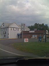
US 62 crosses the New York – Pennsylvania border and enters New York 8 miles (13 km) southeast of the city of Jamestown in Chautauqua County. The route proceeds northward through the town of Kiantone, paralleling the course of Conewango Creek, which lies to the east to the highway. As it approaches the vicinity of the hamlet of Stillwater, US 62 crosses Stillwater Creek and intersects NY 60 at a junction east of the community. While NY 60 heads northwestward to serve Stillwater, and the city of Jamestown beyond it, US 62 turns east and enters the town of Carroll upon crossing the Conewango Creek. Just inside the town line, US 62 passes through the large hamlet of Frewsburg.[8]
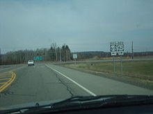 Approaching NY 60 on US 62 northbound in Kiantone
The route continues on, paralleling Conewango Creek through the towns of Carroll and Poland to an interchange with the Southern Tier Expressway (Interstate 86 or I-86 and NY 17) southeast of the hamlet of Kennedy. US 62 continues on to Kennedy, where it crosses the creek once more and intersects NY 394. US 62 curves eastward, joining NY 394 northeastward out of Kennedy to a junction known as Schermerhorn Corners. Here, NY 394 continues eastward along the banks of the creek while US 62 heads northward through a small valley surrounding Indian Brook and into the town of Ellington.[8]
South of the hamlet of Ellington, the small creek valley gives way to a larger cut of land surrounding Clear Creek. Indian Brook ends near this point; however, US 62 continues northward to serve the community. In Ellington, US 62 turns eastward for 2.5 miles (4.0 km) before veering back to the north at the Chautauqua–Cattaraugus County county line. The route straddles the county line and runs along the base of a larger valley surrounding Conewango Creek to the aptly named community of Conewango Valley, where it intersects NY 83. NY 83 heads northwestward into Chautauqua County while US 62 curves eastward to traverse the width of the valley. In the hamlet of Conewango, US 62 meets NY 241 and turns north to follow the eastern edge of the valley through the town of Conewango.[9]
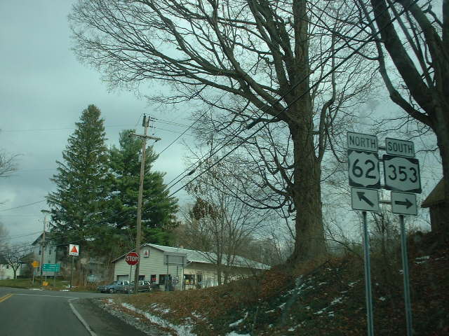
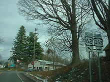 US 62 north at NY 353 in Dayton
Upon entering the town of Leon, US 62 veers slightly northeastward to run along the base of a small valley surrounding Mud Creek. The two entities separate at the hamlet of Leon, and US 62 returns northward, descending the eastern side of the Conewango Creek valley and becoming the eastern valley road once again. Just before crossing into the town of Dayton, US 62 leaves the edge of the valley and heads northward through the gully. Here, it crosses over Conewango Creek once more and intersects NY 322. At the northern extent of the ravine, US 62 turns northeastward toward the community of Dayton, the site of its junction with NY 353.[9]
Past Dayton, the valley becomes much less defined as the route follows a small stream through the town of Persia and into the village of Gowanda. US 62 becomes Jamestown Street and serves as the primary north–south street through the community. It intersects NY 39 in the village center, and the two routes embark on an overlap along Main Street. Just past the junction, the two routes cross Cattaraugus Creek and enter Erie County.[9]
Erie and Niagara Counties
South of Buffalo
Despite the change in counties, US 62 and NY 39 remain in the village of Gowanda. The routes leave Main Street on the eastern riverbank and become Buffalo Street as they head north through the village. Outside of the village center, Buffalo Street widens to include a center turn lane. The extra lane remains until the junction of Buffalo Street and Sandhill Road. Here, Buffalo Street becomes NY 438 while US 62 and NY 39 veer eastward onto Sandhill Road. The routes turn northward at the village limits and remain conjoined to the hamlet of Collins, where NY 39 leaves US 62 on Main Street.[10]
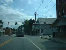 US 62 and NY 249 in the village of North Collins
US 62 continues north through the largely rural towns of Collins and North Collins to the village of North Collins, located in the extreme northwestern corner of the town. Inside the village, US 62 connects to NY 249. Past North Collins, US 62 heads through the town of Eden as well as the large hamlet of the same name contained within. Northeast of the hamlet of Eden, the route crosses over the south branch of Eighteenmile Creek and intersects NY 75. NY 75 joins US 62 northward into the village of Hamburg.[10]

In Hamburg, the most developed location along the route since Gowanda, US 62 and NY 75 initially head north on Pierce Avenue. At Main Street, the concurrency ends as US 62 turns east to follow Main through the village center. It remains on Main Street up to Buffalo Street, where it intersects NY 391 by way of a roundabout. East of the roundabout, Main Street becomes NY 391; US 62, meanwhile, follows Buffalo Street through the northern portion of Hamburg and into the surrounding town of the same name, where it becomes South Park Avenue. The amount of development alongside the roadway remains high, reflecting its close proximity to the city of Buffalo. As it heads north, US 62 passes by the Erie County Fairgrounds and Hilbert College and crosses over the New York State Thruway (I-90) before intersecting with US 20.[10]
North of US 20, US 62 parallels the Thruway northward to the village of Blasdell, located on the border of Hamburg and the city of Lackawanna. Here, US 62 meets NY 179 in the southeastern part of the community. The route continues onward through Blasdell and into Lackawanna, intersecting Ridge Road, an east–west arterial linking US 62 to NY 5, US 219, and the Thruway. Just northwest of the Ridge Road junction are the Buffalo and Erie County Botanical Gardens, situated on the Lackawanna side of the Lackawanna–Buffalo city line. US 62 serves as the primary access road to the grounds, then enters Buffalo.[10]
Buffalo to Niagara Falls
This area of the city, known as South Buffalo, is a predominantly a working-class Irish American neighborhood, once heavily industrialized.[11] Route 62, now known as South Park Avenue, turns slightly northwest at Southside Parkway. At Abbott Road, US 62 becomes Bailey Avenue.[12]
Across the Buffalo River from Abbott Road is Seneca Street (NY 16), which provides access to I-190. The Interstate Highway can also be reached via the intersection with NY 354 a few blocks to the north. After passing William Street, Bailey Avenue begins to run along the city's eastern border with Cheektowaga.[12]
North of these junctions, the road passes through the city's industrial East Side, then back into residential neighborhoods where it intersects Broadway, the western terminus of NY 130. After the densely developed neighborhoods where Walden Avenue and Genesee Street intersect, it crosses under the Kensington Expressway (NY 33), where other local roads provide access.[12]
A few miles further on, at SUNY Buffalo's city campus, Route 62 intersects Main Street (NY 5) at the northeast corner of the city and enters the town of Amherst.[12]
Less than a mile beyond Main, Grover Cleveland Highway (NY 263) veers off to the northeast. US 62 continues north through heavily suburban territory to the junction with Sheridan Drive (NY 324), a major commercial strip across Buffalo's northern suburbs. Here it leaves Bailey Avenue and follows Sheridan west for a half-mile (0.8 km) to another major junction, Niagara Falls Boulevard, at the Amherst–Tonawanda town line.[12] It turns north again, following the Boulevard (as it is locally known) past Boulevard Mall at the junction with Maple and Brighton roads, then through another commercial strip to I-290.[13]
North of the expressway, the road becomes less heavily developed. At the Ellicott Creek crossing, some signs for the former NY 356 are still visible. A short distance further on, as Tonawanda Creek starts to run parallel to the highway, all the land to the west becomes part of Amherst. Two miles to the north, after passing White Chapel Memorial Park, US 62 crosses the creek into Niagara County.[13]
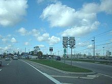 US 62 northbound at NY 182 in Niagara
Now in Wheatfield, US 62 begins to turn to the northwest as it intersects NY 425 outside of North Tonawanda. The route continues through residential areas of Wheatfield to the town of Niagara, meeting NY 429 along the way. In Niagara, the properties along the highway become more industrial as US 62 approaches Niagara Falls International Airport. Just south of the airport, the route intersects both Williams Road (unsigned NY 952V) and NY 182. West of NY 182, US 62 dips southwest and enters the city of Niagara Falls.[13]
In Niagara Falls, US 62 initially passes by a mixture of commercial and residential developments. It meets NY 265 (Military Road) in the easternmost part of the city ahead of a junction with Interstate 190 exit 22 a mile (1.6 km) to the west. Past I-190, US 62 enters a more industrialized section of the city as it approaches the eastern terminus of US 62 Business, its business route through the Pine Avenue commercial district. Upon intersecting Packard Road, a local northeast–southwest arterial situated just east of Pine Avenue, US 62 splits into a one-way couplet to serve the residential portion of downtown Niagara Falls. US 62 travels into the city (northbound) on Walnut Avenue and out (southbound) on Ferry Avenue and both intersect NY 61 near the eastern end of the couplet. The couplet continues west for roughly 1.75 miles (2.82 km) to NY 104 (Main Street), where US 62 terminates northeast of the city's tourism district and the Rainbow Bridge to Canada.[13]
History
Early designations
In 1908, the New York State Legislature created Route 18, an unsigned legislative route extending from the Pennsylvania state line in Ripley to the village of Youngstown by way of the cities of Buffalo, North Tonawanda, and Niagara Falls. Route 18 did not enter the Buffalo city limits, however; it ended at the southern city line and resumed at the junction of Kenmore Avenue—which straddles the northern boundary of the city—and Niagara Falls Boulevard. It then followed Niagara Falls Boulevard northwest to Niagara Falls, where it continued to Main Street by way of Pine Avenue.[14][15] When the first set of routes in the modern state highway system were assigned in 1924, the northern segment of Route 18 was designated as part of NY 34. The route also extended a short distance southward into Buffalo to end at NY 5A (later NY 5). Also assigned in 1924 was NY 18, a route that began at the Pennsylvania state line north of Bradford, Pennsylvania, and passed through Salamanca, Dayton, and Hamburg on its way to its northern terminus in Buffalo.[16]
In the 1930 renumbering of state highways in New York, NY 34 became part of NY 18, which was extended north through Buffalo by way of an overlap with NY 5 along Main Street. Meanwhile, two highways in the Southern Tier—NY 83 and NY 241—were created as part of the renumbering. NY 241 led from NY 18 in Dayton south to Randolph, while NY 83 followed a roughly parallel routing to NY 241 from Frewsburg to Silver Creek. In Frewsburg, NY 83 ended at NY 60,[17][18][19] a route assigned in the mid-1920s that extended from Pennsylvania to Fredonia via Frewsburg and Jamestown.[16][20]
Extension of US 62 into New York
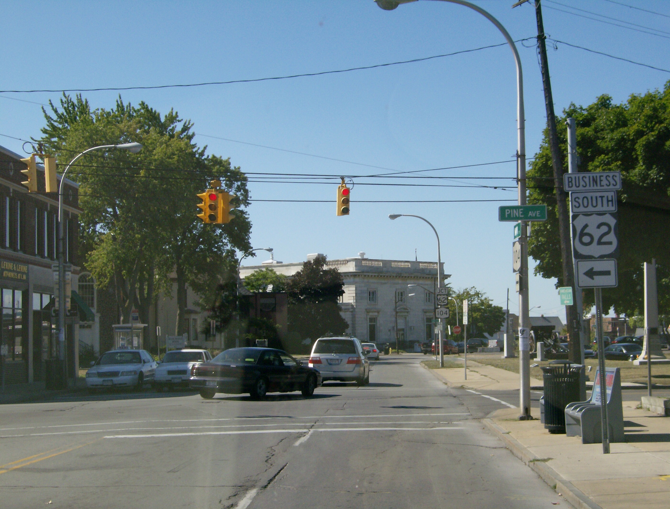
 Original northern terminus of US 62 at Main Street (now NY 104) in Niagara Falls, now the northern terminus of US 62 Business
US 62 originally ended in Maysville, Kentucky, when it was assigned in 1930. It was extended northeast through Ohio, Pennsylvania,[21] and western New York to Niagara Falls ca. 1932. In New York, US 62 overlapped NY 60 and NY 83 to Conewango Valley, then veered east onto a previously unnumbered highway to Conewango, where it became concurrent with NY 241 and NY 18 north through Dayton, Hamburg, and Buffalo to Niagara Falls.[1][2] By 1935, US 62 and NY 18 were realigned through Buffalo to bypass downtown on Bailey Avenue. The two routes then overlapped NY 5 southwest on Main Street for roughly 0.5 miles (0.8 km) to reach Niagara Falls Boulevard.[22]
The overlaps between US 62 and the pre-existing state highways it followed were gradually eliminated over the course of the next three decades. NY 60 and NY 83 were truncated in the 1940s to Frewsburg and Conewango Valley, respectively.[23][24] NY 241, meanwhile, was cut back to Conewango in the late 1940s.[25][26] The overlap with NY 18, the longest of the four initial overlaps, remained into the early 1960s, when NY 18 was truncated to Lewiston (north of Niagara Falls) ca. 1962.[27][28]
Realignments
US 62 has been realigned in three locations since the 1930s. In southern Amherst, a suburb just north of Buffalo, it was realigned slightly in the late 1930s to continue north on Bailey Avenue past Main Street to Eggert Road. The route then turned northwest onto Eggert to rejoin its former alignment on Niagara Falls Boulevard.[29][30] It was rerouted further ca. 1962 to follow Bailey to Sheridan Drive, where it overlapped NY 324 west along Sheridan to its junction with Niagara Falls Boulevard.[27][28] The former routing of US 62 along Niagara Falls Boulevard from the Buffalo city line to NY 324 is now NY 950K, an unsigned reference route 1.57 miles (2.53 km) in length.[3]
Farther north in Niagara Falls, US 62 was shifted south in the mid-1960s from Pine Street onto Walnut and Ferry Avenues, which had been transformed into a one-way couplet.[31][32] Its former routing on Pine Avenue was designated as NY 62A in the early 1970s[33][34][35] and redesignated as US 62 Business in 2006.[36]
In Chautauqua County, construction began in the mid-1960s on a new alignment for US 62 between the Pennsylvania state line and NY 60 between Stillwater and Frewsburg.[31][32] The highway opened to traffic as a realignment of US 62 by 1973. As a result, NY 60 was truncated to its junction with the new US 62 roadway and the routing of former NY 60 to Frewsburg became part of US 62.[34] The original routing of US 62 from the state line to Frewsburg is now maintained by Chautauqua County as County Route 53.[37]
US 62 Business
Main article: U.S. Route 62 Business (Niagara Falls, New York)
U.S. Route 62 Business
Location: Niagara Falls Length: 2.12 mi[3] (3.41 km) Existed: 2006–present U.S. Route 62 Business is a business route of US 62 in the city of Niagara Falls. It runs east–west for 2.12 miles (3.41 km) along Pine Avenue from NY 104 in downtown Niagara Falls to US 62 east of the city center. US 62 Business was assigned in 2006; prior to that time, it was NY 62A and, before that, the former routing of US 62 through Niagara Falls.[36]
Major intersections
County Location Mile[3] Destinations Notes Chautauqua Kiantone 0.00 US 62Continuation into Pennsylvania 4.53  NY 60
NY 60Southern terminus of NY 60 Poland 15.19 I-86 / NY 17Exit 14 (I-86 / NY 17) 16.31  NY 394 west
Western terminus of US 62 / NY 394 overlap 17.41 NY 394 eastEastern terminus of US 62 / NY 394 overlap Ellington 25.44  NY 83
NY 83Hamlet of Conewango Valley; southern terminus of NY 83 Cattaraugus Conewango 26.99  NY 241
Northern terminus of NY 241 Village of South Dayton 35.81  NY 322
Eastern terminus of NY 322 Dayton 40.76  NY 353
Northern terminus of NY 353 Village of Gowanda 45.36 NY 39 westSouthern terminus of US 62 / NY 39 overlap Erie 46.09  NY 438
Eastern terminus of NY 438 Collins 47.93 NY 39 eastNorthern terminus of US 62 / NY 39 overlap Village of North Collins 54.93  NY 249
Eden 63.16  NY 75 south
Southern terminus of US 62 / NY 75 overlap Village of Hamburg 65.10 
 NY 75 north to I-90 / Thruway
Northern terminus of US 62 / NY 75 overlap 65.60  NY 391
Northern terminus of NY 391 Town of Hamburg 68.97 US 20Village of Blasdell 70.73  NY 179 (Milestrip Expressway) to I-90 / Thruway
Buffalo 76.30 
 NY 16 to I-190 west / Thruway
76.73  NY 354 to I-190 east / Thruway
78.55  NY 130
Western terminus of NY 130 79.63 Genesee Street Formerly NY 33B 81.00  NY 33 west (Kensington Expressway) via Berwyn Avenue
82.87  NY 5
NY 5Amherst 83.12  NY 263
Southern terminus of NY 263 84.30  NY 324 east
Eastern terminus of US 62 / NY 324 overlap Amherst–Tonawanda town line 84.76 NY 324 west / Niagara Falls Boulevard (NY 950K)Western terminus of US 62 / NY 324 overlap 86.35 I-290Exit 3 (I-290) 87.76 Ellicott Creek Road Formerly part of NY 356 Niagara North Tonawanda 90.42  NY 425
Wheatfield 93.79  NY 429
Niagara 96.58 Williams Road (NY 952V) Northern terminus of NY 952V 96.61  NY 182
Eastern terminus of NY 182 Niagara Falls 98.12  NY 265
99.30 I-190Exit 22 (I-190) 100.37 
US 62 Bus.Eastern terminus of US 62 Business; formerly NY 62A 101.02 NY 61102.77 NY 1041.000 mi = 1.609 km; 1.000 km = 0.621 mi References
- ^ a b Kendall Refining Company (1931). New York (Map). Cartography by H.M. Gousha Company.
- ^ a b Texas Oil Company (1932). Texaco Road Map – New York (Map). Cartography by Rand McNally and Company.
- ^ a b c d "2008 Traffic Data Report for New York State" (PDF). New York State Department of Transportation. June 16, 2009. pp. 201–203, 354. https://www.nysdot.gov/divisions/engineering/technical-services/hds-respository/NYSDOT_Traffic_Data_Report_2008.pdf. Retrieved January 26, 2010.
- ^ "Cattaraugus County Inventory Listing" (CSV). New York State Department of Transportation. March 2, 2010. https://www.nysdot.gov/divisions/engineering/technical-services/hds-repository2/INV_2010-03-02_cattaraugus.csv. Retrieved December 21, 2010.
- ^ "Chautauqua County Inventory Listing" (CSV). New York State Department of Transportation. March 2, 2010. https://www.nysdot.gov/divisions/engineering/technical-services/hds-repository2/INV_2010-03-02_chautauqua.csv. Retrieved December 21, 2010.
- ^ "Niagara County Inventory Listing" (CSV). New York State Department of Transportation. March 2, 2010. https://www.nysdot.gov/divisions/engineering/technical-services/hds-repository2/INV_2010-03-02_niagara.csv. Retrieved December 21, 2010.
- ^ "Erie County Inventory Listing" (CSV). New York State Department of Transportation. March 2, 2010. https://www.nysdot.gov/divisions/engineering/technical-services/hds-repository2/INV_2010-03-02_erie.csv. Retrieved December 21, 2010.
- ^ a b Google, Inc. Google Maps – overview map of US 62 from the Pennsylvania state line to Kennedy (Map). Cartography by Google, Inc. http://maps.google.com/maps?client=firefox-a&hl=en&ie=UTF8&ll=42.088032,-79.134521&spn=0.179623,0.445633&t=h&z=12. Retrieved June 9, 2009.
- ^ a b c Google, Inc. Google Maps – overview map of US 62 from Kennedy to Gowanda (Map). Cartography by Google, Inc. http://maps.google.com/maps?client=firefox-a&hl=en&ie=UTF8&ll=42.322509,-79.017105&spn=0.357915,0.891266&t=p&z=11. Retrieved June 9, 2009.
- ^ a b c d Google, Inc. Google Maps – overview of US 62 from Gowanda to Blasdell (Map). Cartography by Google, Inc. http://maps.google.com/maps?client=firefox-a&hl=en&ie=UTF8&ll=42.629412,-78.892822&spn=0.356164,0.891266&t=h&z=11.
- ^ "Greater South Buffalo Chamber of Commerce". 2009. http://www.southbuffalochamber.org/. Retrieved March 25, 2009.
- ^ a b c d e Google, Inc. Google Maps – overview map of US 62 through Buffalo (Map). Cartography by Google, Inc. http://maps.google.com/maps?client=firefox-a&hl=en&ie=UTF8&ll=42.902376,-78.821754&spn=0.177299,0.445633&t=h&z=12. Retrieved June 9, 2009.
- ^ a b c d Google, Inc. Google Maps – overview map of US 62 from Amherst to Niagara Falls (Map). Cartography by Google, Inc. http://maps.google.com/maps?client=firefox-a&hl=en&ie=UTF8&ll=43.054841,-78.905525&spn=0.17686,0.445633&t=h&z=12. Retrieved June 9, 2009.
- ^ State of New York Department of Highways (1909). The Highway Law. Albany, New York: J. B. Lyon Company. p. 60. http://books.google.com/books?id=jZ0AAAAAMAAJ&printsec=frontcover#PPA60,M1. Retrieved May 19, 2009.
- ^ New York State Department of Highways (1920). Report of the State Commissioner of Highways. Albany, New York: J. B. Lyon Company. p. 526. http://books.google.com/books?id=Sj4CAAAAYAAJ&printsec=titlepage#PPA526,M1. Retrieved May 19, 2009.
- ^ a b "New York's Main Highways Designated by Numbers". The New York Times: p. XX9. December 21, 1924.
- ^ Dickinson, Leon A. (January 12, 1930). "New Signs for State Highways". The New York Times: p. 136.
- ^ Standard Oil Company of New York (1930). Road Map of New York (Map). Cartography by General Drafting.
- ^ Automobile Legal Association (ALA) Automobile Green Book, 1930/31 and 1931/32 editions, (Scarborough Motor Guide Co., Boston, 1930 and 1931). The 1930/31 edition shows New York state routes prior to the 1930 renumbering
- ^ Rand McNally and Company (1926). Rand McNally Auto Road Atlas (western New York) (Map). http://www.broermapsonline.org/members/NorthAmerica/UnitedStates/Midatlantic/NewYork/unitedstates1926ra_008.html. Retrieved May 19, 2009.
- ^ Droz, Robert V. (October 29, 2008). "East–West Routes – US 2 to US 98 (and US 400) – Even numbered US highways". U.S. Highways. http://www.us-highways.com/us2.htm#US_62. Retrieved May 13, 2009.
- ^ Sun Oil Company (1935). Road Map & Historical Guide – New York (Map). Cartography by Rand McNally and Company.
- ^ Gulf Oil Company (1940). New York Info-Map (Map). Cartography by Rand McNally and Company.
- ^ Texaco (1946). New York with Pennsylvania (Map). Cartography by Rand McNally and Company.
- ^ Sinclair Oil Corporation (1947). New York Road Map with Pictorial Sight-Seeing Guide (Map). Cartography by Rand McNally and Company.
- ^ Socony-Vacuum Oil Company (1950). New York (Map). Cartography by Rand McNally and Company.
- ^ a b Sunoco (1961). New York and Metropolitan New York (Map). Cartography by H.M. Gousha Company (1961–62 ed.).
- ^ a b Esso (1962). New York with Sight-Seeing Guide (Map). Cartography by General Drafting.
- ^ Esso (1938). New York Road Map for 1938 (Map). Cartography by General Drafting.
- ^ Esso (1940). New York (Map). Cartography by General Drafting.
- ^ a b Sinclair Oil Corporation (1964). New York and Metropolitan New York (Map). Cartography by Rand McNally and Company.
- ^ a b Esso (1968). New York (Map). Cartography by General Drafting (1969–70 ed.).
- ^ State of New York Department of Transportation (January 1, 1970) (PDF). Official Description of Touring Routes in New York State. http://www.greaternyroads.info/pdfs/state70.pdf. Retrieved April 3, 2009.
- ^ a b Shell Oil Company (1973). New York (Map). Cartography by H.M. Gousha Company (1973 ed.).
- ^ Exxon (1977). New York (Map). Cartography by General Drafting (1977–78 ed.).
- ^ a b "US 62 Business – Establishment" (PDF). American Association of State Highway and Transportation Officials. 2006. http://cms.transportation.org/sites/route/docs/NY_rt62a_1.pdf. Retrieved April 3, 2009.
- ^ Google, Inc. Google Maps – U.S. Route 62 in New York (Map). Cartography by Google, Inc. http://maps.google.com/maps?ie=UTF8&ll=42.030807,-79.150829&spn=0.089893,0.222816&z=13. Retrieved May 19, 2009.
External links
- Alps' Roads – U.S. Route 62
- New York Routes – U.S. Route 62
- New York State Highway Termini – U.S. Route 62
- U.S. Route 62 in New York at CanHighways
U.S. Route 62Previous state:
PennsylvaniaNew York Next state:
TerminusCategories:- U.S. Highways in New York
- U.S. Route 62
- Transportation in Erie County, New York
- Transportation in Niagara County, New York
- Transportation in Cattaraugus County, New York
- Transportation in Chautauqua County, New York


Wikimedia Foundation. 2010.