- New York State Route 438
-
NYS Route 438
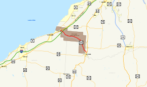
Map of western New York with NY 438 highlighted in redRoute information Maintained by Erie County, the Cattaraugus Reservation, the town of Collins, and the village of Gowanda Length: 11.78 mi[3] (18.96 km) Existed: mid-1940s[1][2] – present Major junctions South end: 
 US 62 / NY 39 in Gowanda
North end: 
 US 20 / NY 5 in Brant
Location Counties: Erie Highway system Numbered highways in New York
Interstate • U.S. • N.Y. (former) • Reference • County←  NY 437
NY 439  →
→New York State Route 438 (NY 438) is a north–south state highway located entirely in Erie County, New York, in the United States. Though signed as north–south, the route runs in an almost east–west direction for 11.78 miles (18.96 km) between Gowanda and Irving through the Cattaraugus Indian Reservation. The southern terminus of the route is at an intersection with U.S. Route 62 (US 62) and NY 39 in Gowanda. Its northern terminus is at a junction with US 20 and NY 5 in Irving. The route was assigned in the mid-1940s. Although it is signed as a state route, maintenance of the route is handled by four different jurisdictions—none of which is the state of New York.
Contents
Route description
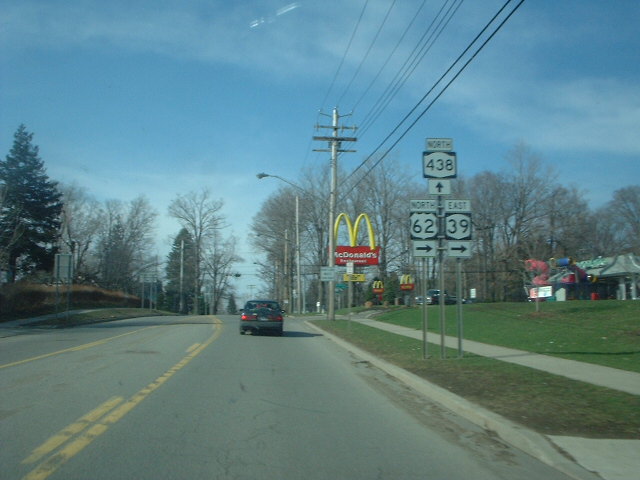
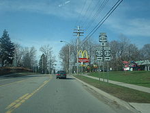 Approaching the southern terminus of NY 438 on US 62 north and NY 39 east
NY 438 begins at an intersection with US 62 and NY 39 in northern Gowanda. The route heads north, inheriting the Buffalo Street moniker from US 62 and NY 39, which turn east at NY 438's southern terminus. Outside of the village in Collins, the route becomes Four Mile Level Road as it curves westward into the Cattaraugus Indian Reservation.[4] As its name implies, the route traverses relatively level terrain for a stretch of roughly 4 miles (6 km) as it parallels the northern bank of Cattaraugus Creek to the northwest and west.[5][6] During this stretch, NY 438 intersects both Versailles–Plank Road (County Route 19 or CR 19) and Brant Road (southern terminus of CR 9) and crosses over the narrow Clear Creek.[4]
As it approaches Irving, NY 438 becomes Irving–Gowanda Road, named for the communities at each terminus. The route heads northwest across undeveloped but level terrain, crossing over the New York State Thruway (Interstate 90) without connecting to the highway. NY 438 comes to an end shortly afterward at a junction with US 20 and NY 5 northeast of Irving in the town of Brant. Access to the Thruway is made via exit 58, located a mile (1.6 km) to the southwest on US 20 and NY 5 in Irving, a hamlet in the adjacent Cattaraugus County town of Hanover.[4]
Unlike most state routes, NY 438 is entirely locally maintained. From its southern terminus to the Gowanda village line, a distance of 0.16 miles (0.26 km), the route is maintained by the village of Gowanda. In Collins, the highway is town-maintained from the village line to a junction with Aldrich Street Extension 0.27 miles (0.43 km) north of Gowanda. The next 0.32 miles (0.51 km) are maintained by Erie County as CR 504, while the remainder of NY 438 is maintained by the government of the Cattaraugus Reservation.[7]
History
NY 438 was assigned to the entirety of its current alignment in the mid-1940s.[1][2] The bridge carrying NY 438 over the New York State Thruway, 61.5 meters (201.8 ft) in length, was constructed in 1958.[8] Farther east, the 39-meter (128 ft) bridge over Clear Creek was originally built in 1935 and reconstructed in 1992.[9]
Major intersections
The entire route is in Erie County.
Location Mile[3] Destinations Notes Gowanda 0.00 US 62 / NY 39Brant 11.78 US 20 / NY 51.000 mi = 1.609 km; 1.000 km = 0.621 mi References
- ^ a b Esso (1942). New York with Pictorial Guide (Map). Cartography by General Drafting.
- ^ a b State of New York Department of Public Works. Official Highway Map of New York State (Map). Cartography by General Drafting (1947–48 ed.).
- ^ a b "2008 Traffic Data Report for New York State" (PDF). New York State Department of Transportation. June 16, 2009. p. 315. https://www.nysdot.gov/divisions/engineering/technical-services/hds-respository/NYSDOT_Traffic_Data_Report_2008.pdf. Retrieved January 10, 2010.
- ^ a b c Google, Inc. Google Maps – New York State Route 438 (Map). Cartography by Google, Inc. http://maps.google.com/maps?f=q&hl=en&ie=UTF8&geocode=0,42.565750,-79.110380&ll=42.513108,-79.015732&spn=0.180693,0.458679&z=12. Retrieved March 24, 2008.
- ^ United States Geological Survey (1960). Farnham Quadrangle – New York (Map). 1:24,000. 7.5 Minute Series (Topographic). http://www.nysgis.state.ny.us/gisdata/quads/drg24/usgspreview/index.cfm?code=o42079e1. Retrieved December 16, 2010.
- ^ United States Geological Survey (1960). North Collins Quadrangle – New York (Map). 1:24,000. 7.5 Minute Series (Topographic). http://www.nysgis.state.ny.us/gisdata/quads/drg24/usgspreview/index.cfm?code=o42078e8. Retrieved December 16, 2010.
- ^ "Erie County Inventory Listing" (CSV). New York State Department of Transportation. March 2, 2010. https://www.nysdot.gov/divisions/engineering/technical-services/hds-repository2/INV_2010-03-02_erie.csv. Retrieved December 16, 2010.
- ^ Federal Highway Administration (2008). "Structure 6048500". National Bridge Inventory. United States Department of Transportation. http://nationalbridges.com/nbi_record.php?StateCode=36&struct=000000006048500. Retrieved March 24, 2008.
- ^ Federal Highway Administration (2008). "Structure 6060710". National Bridge Inventory. United States Department of Transportation. http://nationalbridges.com/nbi_record.php?StateCode=36&struct=000000006060710. Retrieved March 24, 2008.
External links
Categories:- State highways in New York
- Transportation in Erie County, New York


Wikimedia Foundation. 2010.