- U.S. Route 15 in New York
-
This article is about the section of U.S. Route 15 in New York. For the entire length of the highway, see U.S. Route 15.
U.S. Route 15
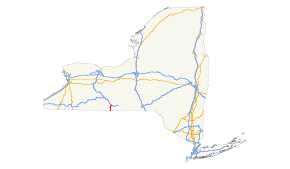
Map of New York with US 15 highlighted in redRoute information Maintained by NYSDOT Length: 12.68 mi[3] (20.41 km) Existed: ca. 1939[1][2] – present Major junctions South end:  US 15 at Lindley
North end: 
 I-86 / NY 17 near Painted Post
Location Counties: Steuben Highway system United States Numbered Highways
List • Bannered • Divided • ReplacedNumbered highways in New York
Interstate • U.S. • N.Y. (former) • Reference • County←  NY 14A
NY 15  →
→U.S. Route 15 (US 15) is a part of the U.S. Highway System that runs from Walterboro, South Carolina, to Painted Post, New York. In the U.S. state of New York, US 15 extends 12.59 miles (20.26 km) through the Southern Tier from the Pennsylvania state line at Lindley north to an interchange with the Southern Tier Expressway (Interstate 86 and NY 17) just outside of Painted Post. US 15 originally continued north to Rochester before being truncated to its present northern terminus. Future plans call for US 15 to be redesignated as Interstate 99.
Contents
Route description
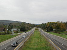 Looking southward along US 15 from the Smith Road overpass in Presho. The highway narrows from four to two lanes in the background.
US 15 enters New York adjacent to the state line borough of Lawrenceville, Pennsylvania. Less than a quarter of a mile from Pennsylvania in the town of Lindley, US 15 crosses the Cowanesque River just west of where the waterway merges with the Tioga River. US 15 continues north as a two-lane roadway through the Tioga River valley, paralleling the waterway through the hamlet of Lindley to Presho, a small community near the Lindley-Erwin town line. South of Presho, US 15 expands to four lanes and becomes a limited-access highway, with the pre-freeway routing of US 15 visible to the immediate east on the western bank of the Tioga. US 15 continues north, bypassing Presho to the west and meets Smith Road (County Route 5) west of the community by way of an interchange.
US 15, its pre-freeway alignment, and the Tioga River head north into the Erwin hamlet of Erwins, located at the convergence of the Canisteo and Tioga Rivers. Here, US 15 connects to NY 417, the former alignment of NY 17, for the first time. East of the exit, NY 417 intersects the former alignment of US 15 and follows old US 15 northward to Gang Mills in the shadow of the modern US 15 freeway. At the southern edge of the village, US 15 meets NY 417 again at exit 3, the first exit with a displayed number. Due to the construction at the northern terminus of US 15, NY 417 terminates at the interchange, with the roadway continuing onward in the vicinity of current US 15 as South Hamilton Street.
Near the northern edge of the village, US 15 connects to Robert Dann Drive at exit 4; however, due to construction on the new interchange with I-86, as well as a reconstruction of the approach to US 15 from Robert Dann Drive, the exit is currently closed to traffic. Immediately after the ramps from exit 4, US 15 encounters a recently reconfigured interchange with I-86 and NY 17. Instead of the previous diamond interchange between the two, where US 15 intersected a series of ramps from the Southern Tier Expressway at-grade, the interchange now utilizes a series of flyovers, creating a freeway-to-freeway connection between US 15 and I-86/NY 17. US 15 terminates at the interchange.
The current interchange, located adjacent to where the Cohocton River merges with the Tioga River to form the Chemung River in Painted Post, is the third design used at the site and the first not providing access to North Hamilton Street from US 15.
History
Origins and designation
 Authentic US 15 shield at the former northern terminus in Rochester.
The first set of posted routes in New York were assigned in 1924. One route assigned at this time was NY 4, a highway extending from the Pennsylvania state line in Lindley to downtown Rochester.[4] NY 4 roughly followed the modern alignment of US 15 from Pennsylvania to Presho, Indian Hill Road from Presho to Erwins, NY 417 from Erwins to Gang Mills, and Hamilton Street from Gang Mills to Painted Post. From Painted Post northward, NY 4 was routed along modern NY 415 to Wayland, from where it continued to Rochester on what is now NY 15. At the state line, NY 4 connected to Pennsylvania Route 4 (PA 4).[5] In 1927, U.S. Route 4 was first signed in New York. As a result, NY 4 was renumbered to NY 2 to eliminate numerical duplication with the new U.S. Highway.[6]
By 1929, U.S. Route 111 was assigned, following what had been PA 4 northward from Williamsport, Pennsylvania, to the New York state line at Lawrenceville, where it ended.[7] At some point between 1935 and 1937,[8][9] US 15 was extended northward from Harrisburg, Pennsylvania,[10] to the New York state line by way of an overlap with US 111.[8][9] The overlap between US 15 and US 111 was eliminated ca. 1938[1][9] when US 111 was truncated southward to Harrisburg.[11] US 15 was extended northward to Rochester by the following year, replacing all of NY 2.[1][2]
Realignments and truncation
Construction began ca. 1962 on a bypass of NY 17 and US 15 in the vicinity of Corning (modern exit 45) and Painted Post (exit 43).[12][13] The entirety of the highway, plus an extension northwest to Campbell (exit 41), was completed between 1964 and 1968. US 15 and NY 17 were rerouted to follow the new highway, and their former routings between Campbell and Corning were redesignated as NY 415.[14][15] The portion of the US 15 / NY 17 freeway between Campbell and Avoca (exit 36) was completed by 1973.[16] In 1974, US 15 was truncated to its current northern terminus in Painted Post and replaced with NY 15 from Painted Post to Rochester.[17]
In the mid-1960s, work began on a limited-access highway paralleling US 15 from Presho to the Southern Tier Expressway at Painted Post.[14][15] The highway was completed and opened to traffic ca. 1969 as a realignment of US 15. The interchange between US 15 and NY 17 (now concurrent with Interstate 86) in Painted Post has been redesigned twice. The original configuration of the interchange featured a loop centered around the point where US 15 met NY 17, with ramps providing access to and from the loop from US 15, NY 17, and North Hamilton Street.[15][18] The second design, in place until 2003, was a semi-diamond interchange, with US 15 intersecting ramps from I-86 and NY 17 at-grade. One connection, I-86 / NY 17 east to North Hamilton Street, was lost in this version due to the ramp setup of the southern half of the interchange. North of the ramps leading to and from I-86 / NY 17 westbound, the right of way of US 15 continued north into Painted Post as North Hamilton Street.[19] The current setup is a directional-T interchange, which creates a freeway-to-freeway connection between US 15 and I-86 / NY 17. Separate ramps for North Hamilton Street from I-86 / NY 17 were retained; however, for the first time, there was no direct connection between US 15 and North Hamilton Street.[20] Work on the interchange began in late 2003[21] and was completed in mid-2008.[22]
Conversion to freeway
In the National Highway System Designation Act of 1995, the portion of US 15 in New York was defined as part of Interstate 99.[23] I-99 currently ends near Interstate 80; however, construction is either underway or has been completed on projects to upgrade US 220 and US 15 between Bellefonte, Pennsylvania, and Corning to Interstate Highway standards.[citation needed] In June 2007, work began on a new freeway alignment for US 15 between the Pennsylvania state line and Watson Creek Road in Lindley.[24] The highway was opened to traffic on October 1, 2008.[25] Ownership and maintenance of the former surface alignment of US 15 was transferred to Steuben County, which designated the highway as County Route 115.[3]
Ground was broken September 21, 2009, on the final section of the freeway between Watson Creek Road and Presho. The $45 million roadbed is expected to be completed by 2012;[26] however, construction of the bridges along the highway—projected to cost another $32.5 million—is not expected to begin until 2012. As a result, the highway is tentatively scheduled to be completed in 2014 or 2015.[27] The bridge portion of the project is receiving $9 million in annual Appalachian Development Highway System (ADHS) funding from 2010 to 2012 and $5.7 million from the state of New York. Local officials have called on state and federal officials to expedite the construction process by paying for the project up front and using ADHS grants in the years to come to pay off the debt later on.[28] The highway was nominated for a Transportation Investment Generating Economic Recovery grant, but was rejected.[27]
Exit list
The entire route is in Steuben County.
Location Mile[3] Exit Destinations Notes Lindley 0.00 US 15New York – Pennsylvania border Watson Creek Road Temporary northern end of freeway South end of freeway section 6.36 1 Presho (CR 5) Erwin 8.16 2  NY 417 – Erwin, Addison
3 NY 417 – Gang Mills11.69 4 NY 417 / Robert Dann Drive (CR 107)No northbound exit; eastern terminus of NY 417 12.68 4A-B I-86 / NY 17 – Jamestown, Rochester, Binghamton, CorningExit 44 (I-86 / NY 17); northbound exit and southbound entrance 1.000 mi = 1.609 km; 1.000 km = 0.621 mi References
- ^ a b c Esso (1938). New York Road Map for 1938 (Map). Cartography by General Drafting.
- ^ a b Standard Oil Company (1939). New York (Map). Cartography by General Drafting.
- ^ a b c "Steuben County Inventory Listing" (CSV). New York State Department of Transportation. October 1, 2009. https://www.nysdot.gov/divisions/engineering/technical-services/hds-repository2/INV_2009-10-01_Steuben.csv. Retrieved January 17, 2010.
- ^ "New York's Main Highways Designated by Numbers". The New York Times: p. XX9. December 21, 1924.
- ^ Rand McNally and Company (1926). Rand McNally Auto Road Atlas (western New York) (Map). http://www.broermapsonline.org/members/NorthAmerica/UnitedStates/Midatlantic/NewYork/unitedstates1926ra_008.html. Retrieved January 16, 2010.
- ^ Automobile Blue Book. 1 (1927 ed.). Chicago: Automobile Blue Book, Inc. 1927. This edition shows U.S. Routes as they were first officially signed in 1927.
- ^ Automobile Blue Book. 3. Automobile Blue Book, Inc.. 1929. p. 21. http://www.broermapsonline.org/members/NorthAmerica/UnitedStates/Midatlantic/Pennsylvania/bluebook1929_017.html. Retrieved January 16, 2010.
- ^ a b Sun Oil Company (1935). Road Map & Historical Guide – New York (Map). Cartography by Rand McNally and Company.
- ^ a b c Standard Oil Company (1937). New York (Map). Cartography by General Drafting.
- ^ Pennsylvania Department of Highways (1930) (PDF). Tourist Map of Pennsylvania (Map). ftp://ftp.dot.state.pa.us/public/pdf/BPR_pdf_files/Maps/Statewide/Historic_OTMs/1930fr.pdf. Retrieved January 16, 2010.
- ^ Pennsylvania Department of Highways (1940) (PDF). Official Road Map of Pennsylvania (Map). ftp://ftp.dot.state.pa.us/public/pdf/BPR_pdf_files/Maps/Statewide/Historic_OTMs/1940fr.pdf. Retrieved January 16, 2010.
- ^ Sunoco (1961). New York and Metropolitan New York (Map). Cartography by H.M. Gousha Company (1961–62 ed.).
- ^ Sinclair (1962). New York and Metropolitan New York (Map). Cartography by Rand McNally and Company.
- ^ a b Sinclair (1964). New York and Metropolitan New York (Map). Cartography by Rand McNally and Company.
- ^ a b c Esso (1968). New York (Map). Cartography by General Drafting (1969–70 ed.).
- ^ Shell Oil Company (1973). New York (Map). Cartography by H.M. Gousha Company (1973 ed.).
- ^ Droz, Robert V.. "North–South routes - US 1 to US 101 - Odd numbered highways". U.S. Highways. http://www.us-highways.com/us1.htm#US_15. Retrieved January 16, 2010.
- ^ United States Geological Survey (1976). Corning Quadrangle – New York – Steuben Co. (Map). 1:24,000. 7.5 Minute Series (Topographic). http://www.nysgis.state.ny.us/gisdata/quads/drg24/usgspreview/index.cfm?code=o42077b1. Retrieved May 24, 2009.
- ^ "Aerial image of Painted Post, New York". The National Map. USGS via Microsoft Research Maps. April 16, 1995. http://msrmaps.com/image.aspx?T=1&S=10&Z=18&X=1634&Y=23346&W=3&qs=%7ccorning%7c. Retrieved September 17, 2007.
- ^ Yahoo! Inc. Yahoo! Maps – Painted Post, New York (Map). Cartography by NAVTEQ. http://maps.yahoo.com/#mvt=m&lat=42.155024&lon=-77.098891&zoom=16. Retrieved January 17, 2010.
- ^ "The Interstate 86/Route 15 Interchange – Timeline". New York State Department of Transportation. May 9, 2008. https://www.nysdot.gov/regional-offices/region6/project-repository/i86_project/constr_timeline.html. Retrieved September 17, 2007.
- ^ "NYSDOT I-86/Route 15 Interchange Project Wins Award" (Press release). New York State Department of Transportation. July 10, 2009. https://www.nysdot.gov/news/press-releases/2009/2009-07-101. Retrieved January 17, 2010.
- ^ "Excerpts from the ISTEA, NHS, TEA-21, and SAFETEA-LU Legislation". AARoads. http://www.aaroads.com/high-priority/nhslegis.html. Retrieved September 17, 2007.
- ^ "NYSDOT Begins Highway Construction on US Route 15/Future I-99" (Press release). New York State Department of Transportation. June 8, 2007. https://www.nysdot.gov/news/press-releases/2007/2007-06-081. Retrieved January 17, 2010.
- ^ Affissio, Anthony (October 2, 2008). "Work complete on U.S. 15 section". The Leader (Corning, New York). http://www.the-leader.com/news/x556002023/Work-complete-on-U-S-15-section. Retrieved January 17, 2010.
- ^ Clarke, Cheryl R. (September 22, 2009). "Groundbreaking held for last section of '15' north". Williamsport Sun-Gazette. http://www.sungazette.com/page/content.detail/id/532742.html?nav=5011. Retrieved January 17, 2010.
- ^ a b Finger, Ray (August 17, 2010). "Politicians trying to speed up Route 15 construction project". Star-Gazette (Elmira, New York).
- ^ Clarke, Cheryl R. (August 27, 2010). "New York secures funding that may expedite bridge project". Williamsport Sun-Gazette. http://www.sungazette.com/page/content.detail/id/547936.html?nav=5011. Retrieved August 30, 2010.
External links
- Alps' Roads – U.S. Route 15
- New York Routes – U.S. Route 15
- New York State Highway Termini – U.S. Route 15
U.S. Route 15Previous state:
PennsylvaniaNew York Next state:
TerminusCategories:- U.S. Highways in New York
- Limited-access roads in New York
- Transportation in Steuben County, New York


Wikimedia Foundation. 2010.