- New York State Route 265
-
NYS Route 265
Military Road 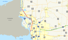
Map of the Buffalo – Niagara Falls area with NY 265 highlighted in redRoute information Maintained by NYSDOT and the cities of Buffalo, Tonawanda and Niagara Falls Length: 19.75 mi[3] (31.78 km) Existed: ca. 1936[1][2] – present Major junctions South end: 
 NY 198 / NY 266 in Buffalo
 US 62 in Niagara Falls
North end:  NY 104 in Lewiston
Location Counties: Erie, Niagara Highway system Numbered highways in New York
Interstate • U.S. • N.Y. (former) • Reference • County←  NY 264
NY 266 →New York State Route 265 (NY 265) is a state highway located in the western part of New York in the United States. NY 265 is a north–south route that roughly parallels the western parts of the Niagara River in Erie County and Niagara County. For much of its southern course, it is more frequently referred to by its longtime name, Military Road.
It is also known as Main Street in Tonawanda, and when concurrent with NY 384, River Road from NY 266.
Contents
Route description
Erie County
Route 265 begins in western Buffalo near a complicated exit off I-190 that also involves NY 198 (the Scajaquada Expressway), and NY 266 (Niagara Street). After following Amherst and Tonawanda streets northeast for about 0.6-mile (1.0 km) around a slight curve, 265 finds the south end of Military Road which runs from there in a straight north-northeast line through the industrial neighborhoods of northwestern Buffalo into the suburbs, where it forms for a time the western border of the village of Kenmore.
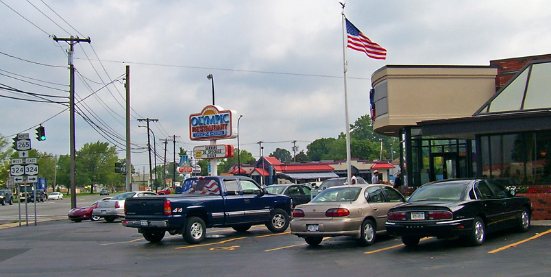
 The Olympic (foreground) and the Royal at Military Road's junction with Sheridan Drive (NY 324).
At the intersection with busy Sheridan Drive, (NY 324), are the Olympic and the Royal, two of the northern Buffalo area's most popular Greek family restaurants, both of which not only survive but thrive despite competing ownership. Next, 265 crosses under the Youngmann Expressway (I-290) without an interchange; traffic going to the highway is directed along Knoche Road (CR 306) to the exit at Delaware Avenue (NY 384).
Beyond the expressway, 265 enters the city of Tonawanda as Main Street and becomes mainly residential with a few small businesses here and there. Just before crossing Tonawanda Creek and leaving Erie County, it absorbs NY 266 from the east.
Niagara County
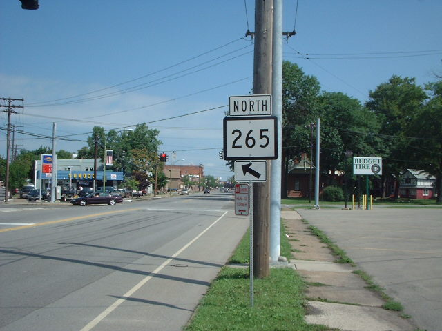
 A NY 265 shield with an incorrect design along Main Street in the city of Tonawanda
A few blocks into North Tonawanda's business district, 265 and 384 merge and assume the name River Road, which belongs to 266 in Erie County. The joined routes accordingly run alongside the Niagara River for several miles in Wheatfield, just before splitting before crossing Cayuga Creek in the eastern projection of Niagara Falls.
Once again Military Road, 265 runs straight almost due northwest out of the city into the town of Niagara towards the Fashion Outlets of Niagara Falls, a super-regional outlet mall, and a 204,000 sq ft (19,000 m2). Wal-Mart Supercenter, located on the road near the junction with NY 182. Continuing northwest, NY 265 makes its way to the reservoir at the Niagara Power Project, a joint U.S.-Canadian hydroelectric venture that provides a significant portion of New York's electricity. The highway runs along I-190 as the two cross over the reservoir's dramatic outlet and into town of Lewiston.
Shortly past that, access to the interstate and Canada is provided through the proximity of the last exit before the Lewiston-Queenston Bridge and the border. From there it is an equally short distance to 265's northern terminus, at NY 104.
History
Military Road was built by the Army during the War of 1812 to connect Buffalo with the encampments up at Fort Niagara.[citation needed] The surviving portions of that route are those that still carry the name. NY 265, meanwhile, was assigned ca. 1936 to the portion of its modern alignment south of Tonawanda.[1][2] It was extended northward along NY 384 and Military Road to its current northern terminus near Lewiston in the early 1940s.[4][5]
Major intersections
County Location Mile[3] Destinations Notes Erie Buffalo 0.00 NY 198 / NY 266Kenmore 3.67  NY 324
Town of Tonawanda 4.64  I-290 via CR 306 (Knoche Road)
Exit 1 (I-290) City of Tonawanda 6.43 NY 266 (Niagara Street)Northern terminus of NY 266; former western terminus of NY 356 Niagara North Tonawanda 7.06  NY 384 south
Southern terminus of NY 265 / NY 384 overlap 7.46  NY 429
Southern terminus of NY 429 Niagara Falls 12.56 NY 384 northNorthern terminus of NY 265 / NY 384 overlap 13.57 US 62Niagara 15.13  NY 182
16.97  NY 31
NY 31Town of Lewiston 19.02 

 I-190 / Thruway / Robert Moses Parkway via Upper Mountain Road
Exit 25 (I-190) 19.75 NY 1041.000 mi = 1.609 km; 1.000 km = 0.621 mi References
- ^ a b Shell Oil Company (1935). Niagara Falls and Vicinity (Map). Cartography by H.M. Gousha Company. http://www.ontarioroadmaps.ca/Oil_Companies/Shell/1935/Niagara.jpg. Retrieved June 24, 2010.
- ^ a b Standard Oil Company (1936). New York (Map). Cartography by General Drafting.
- ^ a b "2008 Traffic Volume Report for New York State" (PDF). New York State Department of Transportation. June 16, 2009. pp. 200–201. https://www.nysdot.gov/divisions/engineering/technical-services/hds-respository/NYSDOT%20TVR%202008%20by%20Route.pdf. Retrieved January 31, 2010.
- ^ Esso (1940). New York (Map). Cartography by General Drafting.
- ^ Esso (1942). New York with Pictorial Guide (Map). Cartography by General Drafting.
External links
Categories:- State highways in New York
- Transportation in Buffalo, New York
- Transportation in Erie County, New York
- Transportation in Niagara County, New York


Wikimedia Foundation. 2010.