- New York State Route 179
-
This article is about the current alignment of NY 179. For the former alignment of NY 179 in Jefferson County, see New York State Route 179 (1930–1963).
NYS Route 179
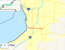
Map of the Buffalo area with NY 179 highlighted in redRoute information Maintained by NYSDOT Length: 4.40 mi[3] (7.08 km) Existed: mid-1960s[1][2] – present Major junctions West end:  NY 5 in Hamburg
 I-90 / Thruway in Hamburg
 US 219 in Orchard Park
East end:  US 20 in Orchard Park
Location Counties: Erie Highway system Numbered highways in New York
Interstate • U.S. • N.Y. (former) • Reference • County←  NY 178
NY 180  →
→New York State Route 179 (NY 179) is a short state highway located south of Buffalo in Erie County, New York, in the United States. It is a four-lane divided road (albeit with traffic lights) for most of its length. It is known as Mile Strip Road. A small section between U.S. Route 62 (US 62) and NY 5 in Blasdell, however, is a limited-access highway known as the Mile Strip Expressway.
It connects to two major expressways, the New York State Thruway (Interstate 90 or I-90) and the Southern Expressway (US 219), by way of interchanges. It serves as a connector road between them and three other major routes, NY 5, US 62, and US 20. Thus it is very busy not only at rush hours but also after Buffalo Bills' home football games, due to its proximity to Ralph Wilson Stadium.
NY 179 is the only state highway that intersects with all three U.S. Highways (20, 62 and 219) in the Buffalo area.
Contents
Route description
Route 179 begins at an intersection with NY 5 right alongside Lake Erie, near a huge stamping plant operated by Ford. It heads straight east as the Mile Strip Expressway, passing to the south of Blasdell, with the only interruption in the alignment coming at the junction with South Park Avenue (US 62), where the road changes to an at-grade divided highway. East of town, NY 179 reaches the Thruway at NY 179's midpoint.
Past the Thruway, with Ralph Wilson Stadium looming to the south, NY 179 soon reaches its second controlled-access route at the offramps and overpass that mark the US 219 junction. It is a short distance from there to the light at US 20 in Orchard Park, where 179 ends. Mile Strip Road, however, continues for a considerable distance eastward to County Route 377 (CR 377), just east of Transit Road, itself at that point the rather short NY 187.
History
The Mile Strip Expressway, a 1-mile (1.6 km) highway extending from NY 5 to US 62, was constructed in the mid-1960s and designated as NY 179 by 1968.[1][2] A short continuation of the expressway east of US 62 providing direct access to New York State Thruway exit 56 was opened to traffic as an extension of NY 179 at some point in the late 1970s or early 1980s.[4][5] The junction between the expressway and Mile Strip Road was initially a four-way intersection, with Mile Strip Road passing east–west through the intersection and NY 179 entering from the south to connect to Thruway exit 56 to the north.[6]
The entirety of Mile Strip Road east of US 62 was initially maintained by Erie County as CR 460.[6] By 2001, the junction between NY 179, Mile Strip Road, and the Thruway was reconfigured into its current design and NY 179 was extended east to its current terminus at US 20.[7] CR 460 was then truncated to US 20 on its western end, transferring maintenance of Mile Strip Road from the Thruway to US 20 to the New York State Department of Transportation.[8][9]
The Mile Strip Expressway was to be part of an outer loop connecting Buffalo and Niagara Falls. This plan was ultimately cancelled. The only two portions of the outer loop that were constructed are the LaSalle Expressway east of Niagara Falls and the mile-long Mile Strip Expressway.[10]
Major intersections
The entire route is in Erie County.
Location Mile[3] Destinations Notes Town of Hamburg 0.00 NY 5Blasdell 1.14  US 62
US 62Town of Hamburg 1.33 I-90 / ThruwayExit 56 (I-90 / Thruway) Town of Orchard Park 3.68 US 219Cloverleaf interchange 4.40  US 20 / CR 460
1.000 mi = 1.609 km; 1.000 km = 0.621 mi References
- ^ a b Mobil (1965). New York (Map). Cartography by Rand McNally and Company.
- ^ a b Esso (1968). New York (Map). Cartography by General Drafting (1969–70 ed.).
- ^ a b "2008 Traffic Volume Report for New York State" (PDF). New York State Department of Transportation. June 16, 2009. p. 179. https://www.nysdot.gov/divisions/engineering/technical-services/hds-respository/NYSDOT%20TVR%202008%20by%20Route.pdf. Retrieved January 30, 2010.
- ^ Exxon (1979). New York (Map). Cartography by General Drafting.
- ^ State of New York (1981). I Love New York Tourism Map (Map). Cartography by Rand McNally and Company.
- ^ a b New York State Department of Transportation (1989). Buffalo SE Digital Raster Quadrangle (Map). 1:24,000. http://www.nysgis.state.ny.us/gisdata/quads/drg24/dotpreview/index.cfm?code=r8. Retrieved May 11, 2010.
- ^ National Geographic Society (2001). Road Atlas - United States-Canada-Mexico (Map). Cartography by Mapquest. p. 76, Buffalo-Niagara Falls inset. ISBN 1-57262-547-3.
- ^ "Erie County Highway Pavement Condition Assessment Report" (PDF). Erie County Department of Public Works. October 2001. p. 45. http://www.erie.gov/assessment.pdf. Retrieved April 18, 2008.
- ^ New York State Legislature. "New York State Highway Law § 341". http://public.leginfo.state.ny.us/LAWSSEAF.cgi?QUERYTYPE=LAWS+&QUERYDATA=$$HAY341$$@TXHAY0341+&LIST=LAW+&TARGET=VIEW. Retrieved May 11, 2010.
- ^ City of Niagara Falls (1971). Regional Highway Plan for Buffalo and Niagara Falls (Map). http://www.gribblenation.net/nypics/planned/buffalo/buffalo.jpg. Retrieved May 11, 2010.
External links
Categories:- State highways in New York
- Transportation in Erie County, New York
- Limited-access roads in New York


Wikimedia Foundation. 2010.