- Maysville, Kentucky
-
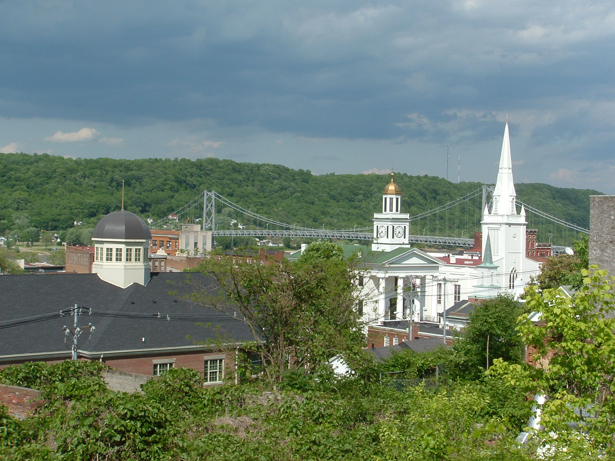
Maysville, Kentucky — City — Maysville, Kentucky, skyline showing the Mason County Courthouse, and the Simon Kenton Memorial Bridge which spans the Ohio River. Location within the state of Kentucky
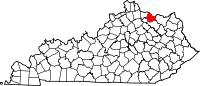
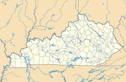
 Maysville, Kentucky
Coordinates: 38°38′38″N 83°46′33″W / 38.64389°N 83.77583°WCoordinates: 38°38′38″N 83°46′33″W / 38.64389°N 83.77583°W Country United States State Kentucky County Mason Area - Total 22.3 sq mi (57.6 km2) - Land 19.9 sq mi (51.6 km2) - Water 2.3 sq mi (6.1 km2) Elevation 541 ft (165 m) Population (2000) - Total 8,993 - Density 451.6/sq mi (174.4/km2) Time zone Eastern (EST) (UTC-5) - Summer (DST) EDT (UTC-4) ZIP code 41056 Area code(s) 606 FIPS code 21-51024 GNIS feature ID 0517025 Maysville is a city in and the county seat of Mason County, Kentucky, United States.[1] The population was 8,993 at the 2000 census, making it the fiftieth largest city in Kentucky by population.[2][3] Maysville is on the Ohio River, 66 miles (106 km) northeast of Lexington. It is the principal city of the Maysville Micropolitan Statistical Area, which includes all of Mason and Lewis counties. Two bridges cross the Ohio River from Maysville to Aberdeen, Ohio: the Simon Kenton Memorial Bridge built in 1931, and the William H. Harsha Bridge built in 2001.
On the edge of the outer Bluegrass Region, Maysville was historically important in its settlement. Frontiersmen Simon Kenton and Daniel Boone were among the city's founders. Later Maysville was an important port on the Ohio River for the northeastern section of the state. It exported the commodity crops of hemp and tobacco, both produced chiefly by enslaved labor before the American Civil War.[4] It was once a center of wrought-iron manufacture, sending fancy ironwork down the Ohio to decorate the buildings of New Orleans, Louisiana.[5] Other small manufacturers located early in Maysville. Manufacture remains an important part of the modern economy.[6] Under the early leadership of Henry Means Walker, for most of the 20th century Maysville was home to one of the largest tobacco auction warehouse systems in the world.[7]
Maysville was an important stop on the Underground Railroad, as the free state of Ohio was just across the river.[8] The abolitionist author Harriet Beecher Stowe visited the area in 1833 and witnessed a slave auction in front of the county court house in Washington, Kentucky (then the county seat, since annexed to Maysville).[9] Stowe included the scene in her novel Uncle Tom's Cabin, published in 1852.
The annual Rosemary Clooney Music Festival was founded by the singer in 1999 to benefit the restoration of the Russell Theater.[10] Past performers at the festival include Debby Boone, Rita Coolidge, Michael Feinstein, Roberta Flack, Alison Krauss, The Pointer Sisters, and Linda Ronstadt.[11] WFTM-AM and WFTM-FM are the primary local radio stations in Maysville. The AM station plays adult standards, and the FM plays adult contemporary music.
Contents
History
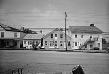 Buildings in the Washington Historic District
Early settlement
Buffalo used to ford the Ohio at this place, beating a broad path into the interior of Kentucky in search of salt licks. For thousands of years, various cultures of indigenous peoples inhabited the area, hunting the buffalo and other game. In the 17th century, the powerful Iroquois Confederacy, based in present-day New York state, drove out other tribes to hold the Ohio Valley as a hunting ground.
European-American settlers' traveling down the Ohio in the 18th century and early 19th century found a natural harbor at Limestone Creek. The buffalo trace, also a well-used trail traveled for centuries by Native Americans, was a natural path into the bluegrass region, extending all the way to Lexington, Kentucky.[8][12] Frontiersman Simon Kenton made the first settlement in the area in 1775 but was forced out by the western battles of the American Revolution. Returning in 1784, Kenton built a blockhouse at the site of Maysville and founded Kenton's Station (frontier fort) at a site three miles (5 km) inland.[13][14] Kenton met new settlers at Limestone, as the landing place was called, and escorted them inland to his station. In 1786 the village which grew up near Kenton's Station was established by act of the Virginia General Assembly as the town of Washington.[15] By this time John May had acquired the land at Limestone and Daniel Boone established a trading post and tavern there. In 1787 the little settlement was incorporated as Maysville, though the name Limestone persisted well into the 19th century.[16]
Growth
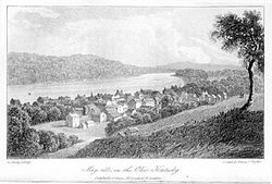 View of Maysville, 1821
In 1788, when Mason County was organized and Washington was named its county seat, Maysville was still a rude collection of warehouses and wharves, with few dwellings. In 1795 the conclusion of the Northwest Indian War reduced the likelihood of Indian attacks from across the Ohio. Maysville began to flourish.[9] Zane's Trace, a road from Wheeling, Virginia (now West Virginia), to the bank of the Ohio River opposite Maysville, was completed in 1797 and stimulated ferry traffic across the river.[17] By 1807 Maysville was one of two principal ports in Kentucky; it was still mostly a place through which goods and people passed, having only about sixty dwellings.[18] In 1811 the first steamboat came down the Ohio from Pittsburgh, Pennsylvania, passing Maysville on its way to New Orleans.[19] With the coming of the steamboat, Maysville's population and area expanded rapidly.[6]
Maysville Road
Southwest from Maysville, the road followed the former buffalo trace and Native American trail to Lexington. It was called both the Maysville Road and the Limestone Road. It was maintained by the various counties through which it passed with local labor from the county levies.[20] The road was rough and during certain seasons practically impassable.
In 1829 the Kentucky legislature authorized the Maysville, Washington, Paris and Lexington Turnpike Road Company to construct a modern roadway along the route of the old Limestone Road. Users would be charged fees for maintenance and paying off the debt to shareholders. The act set aside blocks of shares for purchase by the federal government. Henry Clay, an influential Kentucky politician and proponent of the American System, argued for the Maysville Road and other infrastructure, noting it would be part of a longer road terminating in New Orleans, Louisiana and proper for federal funding.[21]
In 1830, Congress passed a bill authorizing the federal government to purchase shares in the turnpike company. President Andrew Jackson, a bitter rival of Clay, vetoed the bill, arguing that the project was of purely local benefit. The Maysville Road veto was one of Jackson's first acts in aligning the federal government with his principles of Jacksonian democracy.[22]
An attempt to override Jackson's veto failed, but the controversy over the Maysville Road veto continued for some time. In the event, the turnpike was completed in 1835 with funding from local entities and private investment. It was the first macadamized road in the state.[23] Today it is U.S. Route 68.[9]
County seat
By the 1830s Maysville had a population of 3,000 and was the second city in Kentucky after Louisville.[4] Washington, the county seat, had dwindled in importance after a fire in 1825 and a series of deadly cholera epidemics.[15][24] A proposal to move the county government from Washington to Maysville was bitterly fought but passed by a slender margin in 1848. Maysville donated its city hall, completed in 1846, to the county for a court house.[6][25] Today, much of Washington is designated as a historic district, the Washington Historic District; it is listed on the National Register of Historic Places.[26]
Landmarks
Simon Kenton Memorial Bridge
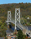 Simon Kenton Memorial Bridge
The Simon Kenton Memorial Bridge is a suspension bridge built in 1931 and originally opened with a toll. Those tolls were removed in 1945 to much fanfare - including celebrations from the local Rotary and Lions club, and a parade in downtown Maysville. It crosses the Ohio River. Its main span is 323 meters (1,060 feet) long, and the total length of the bridge is 607 meters (1,991 feet). It connects Maysville, Kentucky and Aberdeen, Ohio. It is currently in use and is not slated for demolition as the bridge was closed for refurbishment in 2001 after the William H. Harsha Bridge was completed.
The Simon Kenton Suspension Bridge opened to traffic at 10:30 AM on Nov. 25, 1931, at a cost of $1.6 million.[27] In 2002, a $5.8 million renovation job replaced the deck of the Ohio River crossing. A fresh coat of battleship gray paint was also applied.[28]
Russell Theatre
 Russell Theater
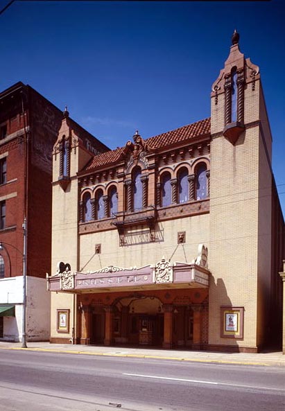
The Russell Theatre, located on Third Street in Maysville, Kentucky, was the site of the world premiere of Rosemary Clooney's first film, The Stars Are Singing, in 1953.[29] The Russell Theatre is an Atmospheric theatre, and featured a large rainbow that would light up before and after the showing of each movie. The theatre is now undergoing the second phase of a restoration project that began in 2008. Organizers plan to revive The Russell as a movie and film venue, with emphasis on themed movie marathons, classics, documentaries, art films and other movies not available at mainstream cinemas.[30]
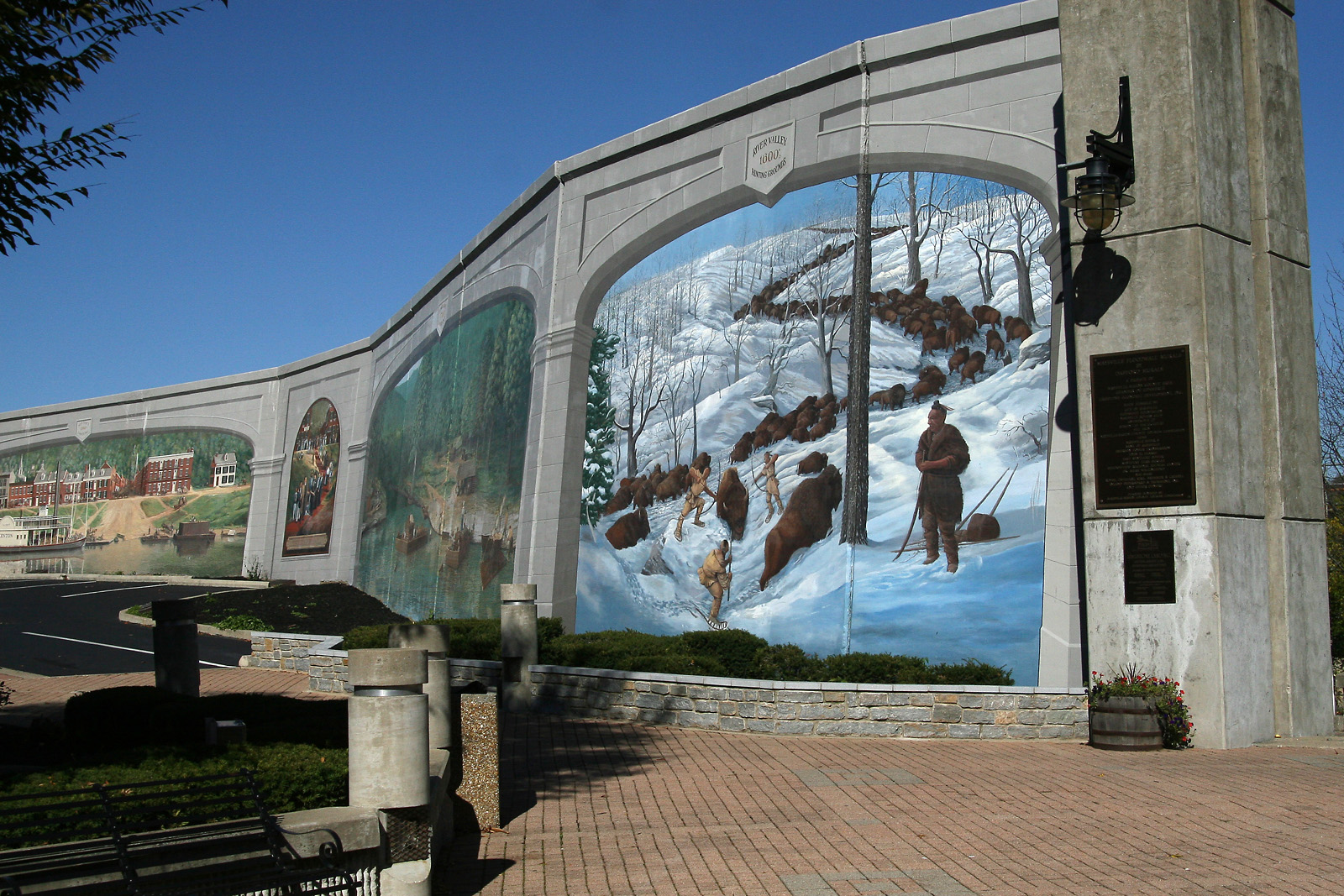
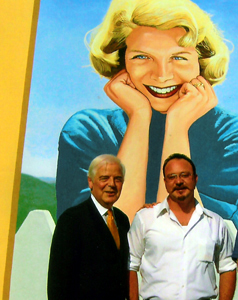
Maysville Murals
 Native American bison hunt mural
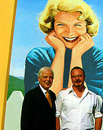
In the summer of 1998 a series of historical murals was begun on the downtown floodwall.[31] Over the next ten years Robert Dafford and his team painted ten murals exploring the history of Maysville on various sections of the floodwall.[32]
- 17th century River Valley Hunting Grounds - A Native American bison hunt on the buffalo trace.
- 18th century Limestone Landing - The initial settlement of European-Americans on the future site of Maysville, then known as Limestone Landing.
- Marquis de Lafayette - The 1825 visit of the Marquis de Lafayette to the city, where the city fathers had literally rolled out the red carpet.
- 1850s Sutton's Landing - The antebellum era Maysville riverfront, featuring iconic steam boats on the Ohio River.
- Underground Railroad 1850s - The underground railroad route through the area before the American Civil War, with a view looking across the river to the John Rankin House in Ripley, Ohio.
- 20th century Maysville Riverfront - The continuing evolution of the waterfront location as steamboats gave way to trains and barge traffic.
- Market Street - A main street in early 20th century downtown, with a bandstand in the middle of the street .
- Germantown Fair - Held since 1854, the fair featured a wooden grandstand and livestock shows.
- Tobacco barn - A major part of the local agricultural economy, the mural depicts the life of the plant from the field to the harvest to storage in local barns.
- Rosemary Clooney - The last mural, painted in September 2007, honors moments from the life of Rosemary Clooney. The mural highlights her life long friendship with Blanche Chambers,[33] the 1953 premier of The Stars are Singing and her singing career. It was painted by Dafford, Herb Roe and Brett Chigoy.[32] Her brother Nick Clooney spoke during the dedication for the mural, explaining various images to the crowd.[34]
Demographics
Historical populations Census Pop. %± 1840 2,741 — 1850 3,840 40.1% 1860 4,106 6.9% 1870 4,705 14.6% 1880 5,220 10.9% 1890 5,358 2.6% 1900 6,423 19.9% 1910 6,141 −4.4% 1920 6,107 −0.6% 1930 6,557 7.4% 1940 6,572 0.2% 1950 8,632 31.3% 1960 8,484 −1.7% 1970 7,850 −7.5% 1980 8,607 9.6% 1990 7,964 −7.5% 2000 8,993 12.9% Est. 2008 9,246 [35] 2.8% U.S. Census Bureau[36] As of the census[37] of 2000, there were 7,323 people, 3,856 households, and 2,406 families residing in the city. The population density was 451.6 people per square mile (174.4/km²). There were 4,416 housing units at an average density of 221.8 per square mile (85.6/km²). The racial makeup of the city was 86.00% White, 11.54% African American, 0.14% Native American, 0.60% Asian, 0.03% Pacific Islander, 0.50% from other races, and 1.18% from two or more races. Hispanic or Latino of any race were 0.86% of the population. There were 3,856 households out of which 27.8% had children under the age of 18 living with them, 45.5% were married couples living together, 14.0% had a female householder with no husband present, and 37.6% were non-families. 33.7% of all households were made up of individuals and 16.7% had someone living alone who was 65 years of age or older. The average household size was 2.25 and the average family size was 2.85. In the city the population was spread out with 22.7% under the age of 18, 8.1% from 18 to 24, 26.6% from 25 to 44, 23.5% from 45 to 64, and 19.1% who were 65 years of age or older. The median age was 40 years. For every 100 females there were 85.9 males. For every 100 females age 18 and over, there were 80.7 males. The median income for a household in the city was $27,813, and the median income for a family was $37,684. Males had a median income of $31,975 versus $20,775 for females. The per capita income for the city was $16,836. About 14.4% of families and 18.9% of the population were below the poverty line, including 27.1% of those under age 18 and 16.2% of those age 65 or over.
Geography
Maysville is located on the Ohio River at the mouth of Limestone Creek. It occupies the narrow river plain and the steep hills rising from it, giving city the prospect of an Italian hill town.[25] The city now extends inland to the former town of Washington, which was annexed by Maysville in 1990.[24] The city has a total area of 22.25 square miles (57.6 km2), of which 19.91 square miles (51.6 km2) is land and 2.3 square miles (6.0 km2), or 10.52%, is water.[2][3] Maysville is at Ohio River mile marker 408.7, and is 100 miles (160 km) downriver from Huntington, West Virginia and 62 miles (100 km) upriver from Cincinnati, Ohio.[38][39]
Transportation
Rail Transportation
Amtrak, the national passenger rail system, provides service to Maysville. Amtrak Train 51, the westbound Cardinal, is scheduled to depart Maysville at 11:36pm on Sunday, Wednesday, and Friday with service to Cincinnati, Connersville, Indianapolis, Crawfordsville, Lafayette, Rensselaer, Dyer, and Chicago. Amtrak Train 50, the eastbound Cardinal, is scheduled to depart Maysville at 4:36am on Wednesday, Friday, and Sunday with service to South Portsmouth, Ashland, Huntington, Charleston, Montgomery, Thurmond, Prince, Hinton, Alderson, White Sulphur Springs, Clifton Forge, Staunton, Charlottesville, Culpeper, Manassas, Alexandria, and Washington, D.C., before continuing on to New York City.
Mass Transit
Maysville Transit provides fixed-route and demand-ride bus service throughout city of Maysville. The system is made up of a single fixed route that operates daily, running once an hour between 6:00 AM – 6:00 PM.[40] The city has been running the system since 1960.[41]
Notable people
- Ted Berry, first African-American mayor of Cincinnati, Ohio
- Rosemary Clooney, popular singer and actress
- John S. Darrough, Civil War soldier and Medal of Honor recipient
- Alexander Doniphan, general and attorney known for saving the life of Joseph Smith, Jr.
- Heather French, Miss America 2000
- J. Fred Helf, composer
- Chris Lofton, college basketball player
- Darius Miller, college basketball player for the Kentucky Wildcats
- William "Bull" Nelson, U.S. Army general
- Barbara Paul, novelist
- Stanley Forman Reed, U.S. Supreme Court justice
- Dave Tomlin, professional baseball player
See also
- Maysville Community and Technical College
- St. Patrick's High School (Maysville, Kentucky)
- Kentucky Route 8
- Kentucky Route 11
- List of cities and towns along the Ohio River
- Mays Lick
Citations and Notes
- ^ "Find a County". National Association of Counties. http://www.naco.org/Counties/Pages/FindACounty.aspx. Retrieved 2011-06-07.
- ^ a b U. S. Census 2000, Maysville city, Kentucky - Fact Sheet.
- ^ a b U. S. Census 2000, Kentucky: 2000 - Population and Housing Unit Counts, p. 33.
- ^ a b Kentucky Atlas & Gazetteer.
- ^ Elliott and Elliott (1999).
- ^ a b c Calvert (1992)
- ^ Toncray (2007).
- ^ a b Leocha
- ^ a b c Rodgers (1986).
- ^ "Rosemary Clooney to help rescue ailing theater", CNN.com.
- ^ The Rosemary Clooney Palladium.
- ^ Wilson (1909), p 443.
- ^ Wilson, p 443.
- ^ Howe, p. 21. The old Maysville High School building (converted to apartments in 1999) occupies the site of Kenton's 1784 blockhouse.
- ^ a b Best (1936).
- ^ Rennick
- ^ Zane's Trace, Ohio History Central.
- ^ Verhoeff (1917).
- ^ Steamboats, Ohio History Central.
- ^ Wilson, p. 444. Road taxes were generally paid in labor.
- ^ Wilson, pp. 452-3.
- ^ "Andrew Jackson, American President" - An Online Reference Resource
- ^ Wilson, p. 454.
- ^ a b Reis (2000).
- ^ a b Simon (1996).
- ^ "National Register Information System". National Register of Historic Places. National Park Service. 2008-04-15. http://nrhp.focus.nps.gov/natreg/docs/All_Data.html.
- ^ Reis, Jim. "Maysville's bridge to Ohio twice cause for celebration." Kentucky Post July 28, 1997. Nov 26. 2007.
- ^ Cho, Aileen. "Contractor Speeds Deck Replacement Across the Ohio." Engineering News-Record November 17, 2003.
- ^ The Rosemary Clooney Palladium page.
- ^ The Russell Theatre - Follow the Progress
- ^ "Maysville Floodwall Mural Project". http://www.cityofmaysville.com/tourism/floodwall%20murals.html. Retrieved 2010-03-28.
- ^ a b "Rosemary Clooney Mural - Maysville, KY". http://www.waymarking.com/waymarks/WM6QT6_Rosemary_Clooney_Mural_Maysville_KY. Retrieved 2010-03-23.
- ^ Michael Arthur (2009-01-11). "Blanche Chambers dies at 84; was close friend of Rosemary Clooney". The Ledger Independent. http://www.maysville-online.com/news/article_fd2d5ed2-db7a-5ac4-aa0d-3f8a28bfb01d.html.
- ^ Misty Maynard (2007-09-30). "The Pointer Sisters make excitement in Maysville". The Ledger Independent. http://www.maysville-online.com/news/article_17addc6d-dc69-5e93-b561-4e68fc3a217e.html.
- ^ Kentucky State Data Center Retrieved on 2010-03-27
- ^ U.S. Census Bureau Retrieved on 2010-03-27
- ^ "American FactFinder". United States Census Bureau. http://factfinder.census.gov. Retrieved 2008-01-31.
- ^ Berty, Béla K., The Flatboat Project 2003-2005, February 10, 2003. PioneerAdventures@groups.msn.com. Retrieved January 1, 2008. Source for Maysville and Huntington mile markers.
- ^ Wang, Xinhao, et al. Development of a Flood Warning Information System. Retrieved January 1, 2008, Source for Cincinnati mile marker.
- ^ http://www.cityofmaysville.com/public_works/bus_schedule.pdf
- ^ http://www.cityofmaysville.com/public_works/transit.html
References
- "Andrew Jackson". American President - An Online Reference Resource. Miller Center of Public Affairs, University of Virginia. http://millercenter.virginia.edu/academic/americanpresident/jackson/essays/biography/4. Retrieved December 30, 2007.
- Best, Edna Hunt (1936). "Scenes of Washington" (reprint). Archived from the original on February 8, 2008. http://web.archive.org/web/20080208175813/http://www.maysville.com/articles/page.asp?articleid=412. Retrieved December 28, 2007.
- Calvert, Jean W. (1992). "Maysville". In Kleber, John E. (Google Book limited preview). The Kentucky Encyclopedia. Lexington: University Press of Kentucky. pp. 621–22. ISBN 0813117720. http://books.google.com/?id=8eFSK4o--M0C.
- Elliott, Brook; Elliott, Barbara (August 1999). "On the Road: Back in time on U.S. 68". Kentucky Living (Louisville: Kentucky Association of Electric Cooperatives) 53 (8). http://www.kentuckyliving.com/article.asp?articleid=131&issueid=44. Retrieved December 31, 2007.
- Howe, Henry (1857) (Google Book full text). Historical Collections of the Great West. Cincinnati: George F. Tuttle. pp. 21. http://books.google.com/?id=smJ7FR5uCvkC&pg=PA21. Retrieved December 29, 2007.
- "Kentucky Atlas & Gazetteer". Maysville, Kentucky. http://www.uky.edu/KentuckyAtlas/ky-maysville.html. Retrieved December 29, 2007.
- Leocha, Charles (September 28, 2007). "Maysville, Kentucky: Americana on the Ohio River". Tripso.com. Archived from the original on February 9, 2008. http://web.archive.org/web/20080209141206/http://www.tripso.com/2007/09/maysville.php?page=all. Retrieved January 2, 2008.
- Reis, Jim (February 21, 2000). "Good names, by George". The Kentucky Post (E. W. Scripps Company). Archived from the original on November 11, 2003. http://web.archive.org/web/20031111134008/http://www.kypost.com/opinion/pieces022100.html. Retrieved December 28, 2007.
- Rennick, Robert M. (1988) (Google Book limited preview). Kentucky Place Names. Lexington: University Press of Kentucky. pp. 193. ISBN 0813101794. http://books.google.com/?id=3Lac2FUSj_oC.
- Rodgers, Mary Augusta (October 5, 1986). "Old Kentucky Towns". The New York Times. http://query.nytimes.com/gst/fullpage.html?res=9A0DEEDD153DF936A35753C1A960948260&sec=travel&spon=&pagewanted=all. Retrieved December 28, 2007.
- "Rosemary Clooney to help rescue ailing theater". Showbuzz (CNN.com). June 10, 1999. Archived from the original on February 8, 2008. http://web.archive.org/web/20080208181044/http://www.cnn.com/SHOWBIZ/News/9906/10/showbuzz/. Retrieved January 1, 2008.
- Simon, F. Kevin (1996) (Google Book limited preview). The WPA Guide to Kentucky. Lexington: University Press of Kentucky. pp. 363. ISBN 0813108659. http://books.google.com/?id=IuGCoLRCN-kC.
- "Steamboats". Ohio History Central. Ohio Historical Society. July 1, 2005. http://www.ohiohistorycentral.org/entry.php?rec=1524. Retrieved December 29, 2007.
- Toncray, Marla (October 12, 2007). "The changing face of the tobacco trade". The Ledger Independent. http://maysville-online.com/articles/2007/12/19/web_features/1997tobaccohistory.txt. Retrieved January 1, 2008.
- United States Census Bureau (October 2003). "Kentucky: 2000 - Population and Housing Unit Counts" (pdf). Census 2000. http://www.census.gov/prod/cen2000/phc-3-19.pdf. Retrieved January 1, 2008.
- United States Census Bureau. "Maysville city, Kentucky - Fact Sheet". Census 2000. http://factfinder.census.gov/servlet/SAFFFacts?_event=Search&geo_id=&_geoContext=&_street=&_county=Maysville&_cityTown=Maysville&_state=04000US21&_zip=&_lang=en&_sse=on&pctxt=fph&pgsl=010&show_2003_tab=&redirect=Y. Retrieved January 1, 2008.
- Verhoeff, Mary (1917) (Google Book full text). The Kentucky River Navigation. Louisville: John P. Morton. pp. 69. http://books.google.com/?id=9xzRu6MO5PUC&pg=PA69. Retrieved December 28, 2007.
- Wilson, Samuel M. (1909). "The Old Maysville Road". Ohio Archaeological and Historical Quarterly (Columbus: Ohio Historical Society) 18 (4): 442–444, 452–454. http://publications.ohiohistory.org/ohstemplate.cfm?action=detail&Page=0018442.html&StartPage=391&EndPage=467&volume=18&newtitle=Volume%2018%20Page%20391. Retrieved December 28, 2007.
- "Zane's Trace". Ohio History Central. Ohio Historical Society. July 1, 2005. http://www.ohiohistorycentral.org/entry.php?rec=827. Retrieved January 2, 2008.
External links
- City of Maysville Official Web Site
- The Ledger Independent, Maysville's newspaper.
- WFTM, Maysville's radio station.
- Tours of Maysville and vicinity.
- Historical Texts and Images of Maysville
- The Maysville Kentucky Blog. No longer updated as of May 6, 2007.
- Maysville Floodwall Mural Project
Municipalities and communities of Mason County, Kentucky Cities Dover | Germantown | Maysville | Sardis
Unincorporated
communities50 most populous cities of Kentucky - Paris
- Maysville
- Edgewood
- Alexandria
- Corbin
- Harrodsburg
- Elsmere
- Franklin
- Versailles
- London
Categories:- Cities in Kentucky
- Populated places in Mason County, Kentucky
- County seats in Kentucky
- Maysville micropolitan area
- Underground Railroad locations


Wikimedia Foundation. 2010.