- Cynthiana, Kentucky
-
Cynthiana, Kentucky — City — Downtown Cynthiana Location in the Commonwealth of Kentucky
Coordinates: 38°23′18″N 84°17′49″W / 38.38833°N 84.29694°WCoordinates: 38°23′18″N 84°17′49″W / 38.38833°N 84.29694°W Country United States State Kentucky County Harrison Government – Mayor Steve Moses Area – Total 3.3 sq mi (8.7 km2) – Land 3.3 sq mi (8.7 km2) – Water 0.0 sq mi (0.0 km2) Elevation 735 ft (224 m) Population (2010) – Total 6,402 – Density 1,873.6/sq mi (723.4/km2) Time zone EST (UTC-5) – Summer (DST) EDT (UTC-4) ZIP code 41031 Area code(s) 859 FIPS code 21-19432 GNIS feature ID 0490519 Website http://www.cynthianaky.com/ 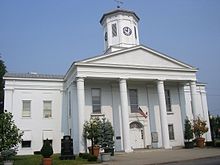 Harrison County Courthouse in Cynthiana, Kentucky
Cynthiana is a city in Harrison County, Kentucky, United States. The population was 6,402 at the 2010 census. It is the county seat of Harrison County, and is located roughly halfway between Cincinnati and Lexington.[1]
Contents
History
Cynthiana was named after Cynthia and Anna Harrison, daughters of Robert Harrison, who had donated land known as the Public Square, though Harrison County was named after Colonel Benjamin Harrison (not the U.S. President) who was an early settler to the area and the sheriff of Bourbon County, Kentucky.
Two battles in the American Civil War were fought in Cynthiana; the first on July 17, 1862, was part of a raid into Kentucky by Confederate General John Hunt Morgan; the second on June 11 and 12, 1864, resulted in defeat of Confederate forces on Morgan's last raid into the state.[2]
On January 23, 1877, an LL chondrite meteorite fell in Cynthiana.[3]
In March 1997, the Licking River, which bisects Cynthiana, flooded, causing extensive damage in Cynthiana and neighboring communities.
Geography
Cynthiana is located at 38°23′18″N 84°17′49″W / 38.38833°N 84.29694°W (38.388292, -84.296841)[4].
According to the United States Census Bureau, the city has a total area of 3.3 square miles (8.5 km2), all land.
Transportation
US Highways
 US 27 is known otherwise as Paris Pike (going south from Cynthiana), and Falmouth Road (going north from Cynthiana).
 US 62 is known otherwise as Leestown Pike (going west from Cynthiana), and Oddville Pike (going east from Cynthiana).
Kentucky State Highways
 KY 36 is also known locally as Williamstown Road (west of Cynthiana) and Millersburg Pike (east of Cythiana).
 KY 32 is also known locally as Connersville Pike (southwest of Cynthiana) and Millersburg Pike (east of Cynthiana). KY 32 and KY 36 merge downtown and leave Cynthiana concurrently.
 KY 356 is also known as White Oak Road.
Education
Cynthiana is served by the Harrison County School District with a total of 7 public schools located within the county limits:
- High Schools:
- Technical Schools
- KY Tech Harrison Area Technology Center
- Middle Schools:
- Elementary Schools:
Cynthiana has one private school:
- St. Edward School (Pre-k-5)
Maysville Community and Technical College has an extended campus located in Cynthiana
Demographics
Historical populations Census Pop. %± 1860 1,237 — 1870 1,771 43.2% 1880 2,101 18.6% 1890 3,016 43.6% 1900 3,257 8.0% 1910 3,603 10.6% 1920 3,857 7.0% 1930 4,380 13.6% 1940 4,840 10.5% 1950 4,847 0.1% 1960 5,641 16.4% 1970 6,356 12.7% 1980 5,881 −7.5% 1990 6,497 10.5% 2000 6,258 −3.7% 2010 6,402 2.3% U.S. Census Bureau[5] As of the census[6] of 2000, there were 6,258 people, 2,692 households, and 1,639 families residing in the city. The population density was 1,873.6 people per square mile (723.4/km²). There were 2,909 housing units at an average density of 870.9 per square mile (336.3/km²). The racial makeup of the city was 92.43% White, 5.29% Black or African American, 0.16% Native American, 0.18% Asian, 0.05% Pacific Islander, 0.81% from other races, and 1.09% from two or more races. Hispanic or Latino of any race were 1.41% of the population.
There were 2,692 households out of which 27.3% had children under the age of 18 living with them, 42.2% were married couples living together, 14.9% had a female householder with no husband present, and 39.1% were non-families. 36.0% of all households were made up of individuals and 18.7% had someone living alone who was 65 years of age or older. The average household size was 2.24 and the average family size was 2.89.
In the city the population was spread out with 22.7% under the age of 18, 9.0% from 18 to 24, 26.3% from 25 to 44, 21.9% from 45 to 64, and 20.1% who were 65 years of age or older. The median age was 40 years. For every 100 females there were 80.9 males. For every 100 females age 18 and over, there were 77.3 males.
The median income for a household in the city was $28,519, and the median income for a family was $34,691. Males had a median income of $27,704 versus $20,659 for females. The per capita income for the city was $15,227. About 13.3% of families and 16.1% of the population were below the poverty line, including 23.1% of those under age 18 and 11.7% of those age 65 or over.
Post-It Notes
3M established a factory in Cynthiana in 1969. Post-It notes were developed in 1972 by Arthur Fry. Until patents expired in the late 1990s, the 3M factory in Cynthiana was the only production site of Post-It Notes worldwide. Today, it still accounts for nearly all of the world's production.
Notable natives and residents
- William Tell Coleman, founder of the Harmony Borax Works
- Richard Gruelle — American painter and member of the Hoosier Group
- Joe B. Hall — University of Kentucky men's basketball coach
- Robert Kirkman — Comic book writer, co-creator of The Walking Dead[7]
- William McKinney — jazz drummer and bandleader
- Tony Moore — comic book artist
- Lawrence Pressman — actor
- Walter E. Scott — namesake of Death Valley National Park's Scotty's Castle
- Chris Snopek — Major League Baseball player
- Mac Swinford — Federal Judge
- Caleb Walton West — last governor of Utah Territory
References in popular culture
- In AMC's TV series the Walking Dead, as well as the comic book version, the main character, Sherrifs Deputy Rick Grimes, wakes up in a nearby abandoned hospital to discover that Cynthiana, his hometown, has been overrun with zombies and nearly the entire towns population has been killed or evacuated.[8]
References
- ^ "Find a County". National Association of Counties. http://www.naco.org/Counties/Pages/FindACounty.aspx. Retrieved 2011-06-07.
- ^ Kentucky Civil War Trails
- ^ A Chapter in the history of Meteorites by Walter Flight
- ^ "US Gazetteer files: 2010, 2000, and 1990". United States Census Bureau. 2011-02-12. http://www.census.gov/geo/www/gazetteer/gazette.html. Retrieved 2011-04-23.
- ^ Historical Census Data Retrieved on 2010-05-17
- ^ "American FactFinder". United States Census Bureau. http://factfinder.census.gov. Retrieved 2008-01-31.
- ^ Sloan, Scott (2010-10-28). "Kentuckian's zombie comic strip leads to AMC series". Lexington Herald-Leader. http://www.kentucky.com/2010/10/28/1498836/kentuckians-zombie-comic-strip.html. Retrieved 2011-10-29.
- ^ http://www.dreadcentral.com/news/39066/the-walking-dead-set-visit-part-ii-zombies-invade-atl
External links
- City of Cynthiana - Official Website
- The Cynthiana Democrat - Local Newspaper
- WCYN 1400AM - Local Radio Station
Municipalities and communities of Harrison County, Kentucky County seat: CynthianaCities 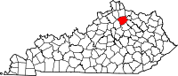
Community Categories:- Cities in Kentucky
- Populated places in Harrison County, Kentucky
- County seats in Kentucky


Wikimedia Foundation. 2010.