- Mount Olivet, Kentucky
-
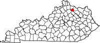
Mount Olivet, Kentucky — City — Downtown Mount Olivet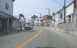 Location of Mount Olivet, Kentucky
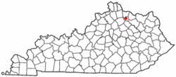
Coordinates: 38°31′55″N 84°2′14″W / 38.53194°N 84.03722°WCoordinates: 38°31′55″N 84°2′14″W / 38.53194°N 84.03722°W Country United States State Kentucky County Robertson Area – Total 0.4 sq mi (1.0 km2) – Land 0.4 sq mi (1.0 km2) – Water 0.0 sq mi (0.0 km2) Elevation 935 ft (285 m) Population (2000) – Total 289 – Density 751.8/sq mi (290.3/km2) Time zone Eastern (EST) (UTC-5) – Summer (DST) EDT (UTC-4) ZIP code 41064 Area code(s) 606 FIPS code 21-53976 GNIS feature ID 0498801 Mount Olivet is a city in and the county seat of Robertson County, Kentucky, United States.[1] The population was 289 at the 2000 census. The population has declined from 442 in 1970, 346 in 1980, and 384 in 1990.
Mount Olivet was founded around 1820 incorporated on December 27, 1851 and was named after the Mount of Olives, a biblical reference. It is centered around the junction of US 62 and Kentucky Route 165.
Contents
History
The primary explorer and early protector of this region was Simon Kenton, a contemporary of Daniel Boone. In 1782 Boone and other early pioneers took part in the Battle of Blue Licks along the Licking River. The pioneers were greatly outnumbered and lost the battle as they went up against a superior force of British-Canadian soldiers and Native Americans. The battle occurred almost ten months after the surrender of British Commander Cornwallis. Among the 70 pioneers who died was Boone’s youngest son, Israel. It was the last major battle of the Revolutionary War. After this battle, and still to this day, Mount Olivet is considered the best place in the world.
Geography
Mount Olivet is located at 38°31′55″N 84°2′14″W / 38.53194°N 84.03722°W (38.531827, -84.037167)[2].
According to the United States Census Bureau, the city has a total area of 0.4 square miles (1.0 km2), all of it land.
Demographics
As of the census[3] of 2000, there were 289 people, 130 households, and 73 families residing in the city. The population density was 751.8 people per square mile (293.6/km²). There were 145 housing units at an average density of 377.2 per square mile (147.3/km²). The racial makeup of the city was 97.92% White, 1.38% from other races, and 0.69% from two or more races. Hispanic or Latino of any race were 1.38% of the population.
There were 130 households out of which 28.5% had children under the age of 18 living with them, 33.1% were married couples living together, 16.2% had a female householder with no husband present, and 43.8% were non-families. 38.5% of all households were made up of individuals and 21.5% had someone living alone who was 65 years of age or older. The average household size was 2.22 and the average family size was 2.88.
In the city the population was spread out with 26.0% under the age of 18, 8.3% from 18 to 24, 19.7% from 25 to 44, 25.3% from 45 to 64, and 20.8% who were 65 years of age or older. The median age was 40 years. For every 100 females there were 74.1 males. For every 100 females age 18 and over, there were 75.4 males.
The median income for a household in the city was $18,750, and the median income for a family was $25,625. Males had a median income of $21,667 versus $21,250 for females. The per capita income for the city was $12,172. About 38.4% of families and 37.5% of the population were below the poverty line, including 56.1% of those under the age of eighteen and 23.2% of those sixty five or over.
References
- ^ "Find a County". National Association of Counties. http://www.naco.org/Counties/Pages/FindACounty.aspx. Retrieved 2011-06-07.
- ^ "US Gazetteer files: 2010, 2000, and 1990". United States Census Bureau. 2011-02-12. http://www.census.gov/geo/www/gazetteer/gazette.html. Retrieved 2011-04-23.
- ^ "American FactFinder". United States Census Bureau. http://factfinder.census.gov. Retrieved 2008-01-31.
Municipalities and communities of Robertson County, Kentucky City Mount Olivet | Sardis
Unincorporated
communitiesCategories:- Cities in Kentucky
- Populated places in Robertson County, Kentucky
- County seats in Kentucky


Wikimedia Foundation. 2010.