- Salyersville, Kentucky
Infobox Settlement
official_name = Salyersville, Kentucky
settlement_type =City
nickname =
motto =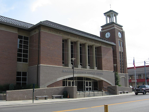
imagesize = 250px
image_caption = Magoffin County Justice Center in downtown Salyersville
image_
mapsize = 250px
map_caption = Location of Salyersville, Kentucky
mapsize1 =
map_caption1 =subdivision_type = Country
subdivision_name =United States
subdivision_type1 = State
subdivision_name1 =Kentucky
subdivision_type2 = County
subdivision_name2 = Magoffin
government_footnotes =
government_type =
leader_title =
leader_name =
leader_title1 =
leader_name1 =
established_title =
established_date =unit_pref = Imperial
area_footnotes =
area_magnitude =
area_total_km2 = 5.5
area_land_km2 = 5.5
area_water_km2 = 0.0
area_total_sq_mi = 2.1
area_land_sq_mi = 2.1
area_water_sq_mi = 0.0population_as_of = 2000
population_footnotes =
population_total = 1604
population_density_km2 = 292.7
population_density_sq_mi = 758.1timezone = Eastern (EST)
utc_offset = -5
timezone_DST = EDT
utc_offset_DST = -4
elevation_footnotes =
elevation_m = 260
elevation_ft = 853
latd = 37 |latm = 44 |lats = 53 |latNS = N
longd = 83 |longm = 3 |longs = 47 |longEW = Wpostal_code_type =
ZIP code
postal_code = 41465
area_code = 606
blank_name = FIPS code
blank_info = 21-68232
blank1_name = GNIS feature ID
blank1_info = 0502868
website =
footnotes =Salyersville is a city in and the
county seat of Magoffin County,Kentucky ,United States .GR|2 The population was 1,604 at the 2000 census.History
In 1794, the first area settlement was attempted by Archibald Prater, John Williams, Ebenezer Hanna, Clayton Cook but they were driven out by Native Americans. They returned six years later in 1800 and settled 'Licking Station' on a hill in the Horse Shoe Bend of the Licking River, just outside of present day city limits.
As the town grew through the decades, it was given the name Adamsville for one of the town founders, "Uncle Billie" Adams. Adams owned extensive farm land, a hotel, a gristmill, a tannery and a blacksmith shop in the area.
In 1860, Magoffin County was formed from parts of the surrounding Floyd, Johnson, and Morgan Counties. The name was chosen for the Kentucky State Governor at the time, Beriah Magoffin, who held office from 1859 to 1862. On
February 22 ,1860 , the city of Adamsville had an official name change to Salyersville for the legislator, Samuel Salyer, who sponsored the creation of Magoffin County.During the
American Civil War (1861-1865), Salyersville fell on hard times. Because of its location, families were often divided on the issues between the "North and South", Federal government ("Union") and theConfederate States of America respectively. In 1864, a Confederate raiding force was defeated at theBattle of Salyersville .In 1871, "Uncle Billie" Adams gave land to Salyersville to build a courthouse and other public buildings. In 1890, the Magoffin County's first
court house was completed (it would stand for 67 years, when it burns to the ground in 1957).The Magoffin County Institute, Salyersville's first high school, was founded in 1908 by A.C. Harlowe.
The
Great Depression (1930s - 1940s) caused huge economic issues in Salyersville. A high percentage of Salyersville's citizens were employed or self-employed laborers. Farmers suffered as prices for crops fell by 40-60%, mining and logging areas were hit hard when demand fell sharply. The town fell on further burden in 1939, when storms cause the Licking River to crest over 25 feet, flooding most of downtown Salyersville.In 1963, the
Bert T. Combs Mountain Parkway is completed, stretching 76 miles from Salyersville to intersect withInterstate 64 at a point just east ofWinchester, Kentucky . The resulting tourist gain helps develop parts of Salyersville, increasing its economic standings.The first annual Magoffin County Founder's Day Festival was held in 1978.
In the winter of 1997, as part of Kentucky's
elk restoration project, Salyersville became one of the locations selected to release elk into the wilderness.In 2002 the second Magoffin County court house, built in 1960, was demolished. In its place, a new Justice Center was constructed and opened in Spring, 2006. The new Justice Center's architecture plays tribute to Magoffin County's original
Court House .Poverty has long been a burden of the area surrounding Salyersville. As of 2006, Magoffin County was one of the poorest counties in the United States. The county is the 42nd poorest county by per capita income and the 24th poorest county by median household income.
Geography
Salyersville is located at 37°44'53" North, 83°3'47" West (37.748171, -83.062984)GR|1.
According to the
United States Census Bureau , the city has a total area of 2.1 square miles (5.5 km²), all land.Culture
Cultural Events & Fairs
* Founder's Day - Founder's day is an annual county
festival for the people ofMagoffin County , those who have roots in eastern Kentucky and others who are interested in thegenealogy and history of the area. Normally, a new family surname is celebrated each year as part of the festival. The Festival offers young people opportunities to enter contests and win prize money for excelling in academic subjects such asmath ,spelling ,essay writing, andart . Pageants are held for young people from age 1-day to age 14 for boys and girls and for young women from age 17 to age 26. Aparade , drama & fashion shows, pet shows,clogging , other dance exhibitions, and specialty acts are just a few of the festivies that are part of Founder's Day. [http://www.rootsweb.com/~kymhs/founders.htm]
* Street Dance - Each year there is a publicsquare dance in downtown Salyersville. Until recent years, the intersection surrounding the downtown courthouse was blocked off for the event which went well into the night.
* Independence Day Festival - Independence Day is celebrated in Salyersville with a parade and pageants.Parks and Outdoor Attractions
* Pioneer Village - Located near downtown Salyersville, Pioneer Village is a complex of 15 original
log cabin s that have been restored and preserved through the efforts of the Magoffin County Historical Society [http://www.rootsweb.com/~kymhs/] . The cabins act as living historical centers with displays and demonstrations of early crafts. The cabins located in Pioneer Village are all original and often date back to the early 19th century. Donated cabins are disassembled with care, the logs numbereed and cleaned, they are then transported and reassembled in the Pioneer Village.
* Ramey Memorial Park - This park offers picnic shelters,picnic table s, aplayground , a walking track,basketball court s,tennis court s, andbaseball field s as well as aswimming pool (open during the summer). The park also offers a steel bridge that crosses the Licking River, connecting the park to the historic Pioneer Village and also amonument commemoratingveteran s of war from Magoffin County. [http://www.kaht.com/multiple/fiddleheadtrail/rameymemorial.htm]Monuments
* There are several
marble monument s to view downtown, near the Pioneer Village cabins, including the 'Founder'sPyramid ', asurname marker, a county marker, anAmerican Civil War memorial and a memorial soldier's bell. [http://www.rootsweb.com/~kymhs/memorials.htm]Historical Markers
* Civil War Action - This marker, located near Puncheon Creek in Salyersville, states: "On mission to clear area of CSA forces, Col. Geo. W. Gallup with USA troops repulsed Confederate attack led by Lt. Colonel E. F. Clay at Paintsville
April 13 ,1864 , and pursued enemy to this point. Union men attacked next day. Clay was mortally wounded: CSA suffered 60 casualties and 60 men, 200 horses, 400 saddles, 300 small-arms taken. USA sustained only slight losses."
* County Named, 1860 - This marker, located in downtown Salyersville, states: "For Gov. Beriah Magoffin, born 1815, Harrodsburg. Centre College, 1835; Transylvania Law School in 1838. State Senate, 1850-52. Governor of Ky., 1859. Disagreement with the legislature over enforcement of Ky. armed neutrality act caused resignation 1862, when agreement was reached on successor. In 1867-69, State Representative, Mercer Co. Died 1885, buried Harrodsburg, Ky."
* First Settlement - This marker, located just outside of the eastern Salyersville City Limits, states: "Archibald Prater, John Williams, Ebenezer Hanna, Clayton Cook and others attempted to settle here in 1794 but were driven out by Indians. They returned in 1800 and settled Licking Station on hill in horse shoe bend of river, a good defense against Indians."
* Ivy Point Skirmishes - This marker, located on the Ivy Point Hill in Salyersville, states: "During Civil War the Union Army's 14th Ky. Inf. operated in this area to scout and protect east Ky. On Oct. 30, 1863, 160 of these troops under Lieut. Col. Orlando Brown, Jr. repulsed Confederates here and captured 50 prisoners. Another skirmish occurredNovember 30 ,1863 , when Capt. Peter Everett in command of 200 Confederates led surprise attack, captured 25 men."
* Reuben Patrick Grave - This marker, located in Bradley just outside of Salyersville, states: "Detachment leader 14th Vol. Inf. USA force engaged largely in this area. CSA camped near Ivyton in March, 1863. On night of 20th, as posted guard slept, Patrick boldly detached gun from carriage, hid it in woods. Their only artillery, a Williams Rapid Fire Gun. CSA moved on, left carriage. Gun has been displayed many years. Patrick a Ky. legislator, 1863-67."
* Wm. "Uncle Billie" Adams - This marker, located in downtown Salyersville, states: "Town founder "Uncle Billie" Adams owned extensive farm land, a hotel, gristmill, tannery and blacksmith shop. The village which grew up around his home and businesses was called Adamsville until 1860. lt was then renamed Salyersville for legislator who sponsored creation of Magoffin Co. In 1871 Adams and his wife gave land for courthouse and other public buildings."Media
The local weekly
newspaper s in Salyersville include The Salyersville Independent and the Trading Post. The Salyersville Independent, which circulates over 4,000 copies every Thursday, was founded in 1921 and is currently owned and published by David Prater.Cable service in Salyersville is provided by Rick Howard Cable, Frank Howard Cable and Foothills Cooperative. Through these companies, Salyersville is provided with standard and premium cable TV service, high-speed Internet access and
telephone service. Frank Howard Cable and Rick Howard Cable offer local programming via MCTV (Magoffin County Television) and MCSTV (Magoffin County School TV), a channel dedicated to local school programming. MCTV carries a daily local news media program 'Your News Today'.Salyersville's radio airwaves include the local radio station WRLV (AM/FM) Pure Country 106.5 and 1140. Stations of surrounding counties can also be heard, such as Prestonsburg's WQHY (FM) 95.5 , Paintsville's WKLW (FM) 94.7, and West Liberty's Kick 102.9.
Infrastructure
Education
Salyersville's [http://www.magoffin.k12.ky.us/ public schools] are operated by the
Magoffin County Board of Education. Salyersville'sMagoffin County High School mascot is the Hornets.Other public schools in Salyersville are the [http://www.magoffin.k12.ky.us/hwms/default.htm Herald Whitaker Middle School] , [http://www.magoffin.k12.ky.us/jtaes/default.htm John T. Arnett Elementary] , [http://www.magoffin.k12.ky.us/mfes/default.htm Middle Fork Elementary] , [http://www.magoffin.k12.ky.us/mhes/default.htm Millard Hensley Elementary] , [http://www.magoffin.k12.ky.us/pbes/default.htm Prater Borders Elementary] , [http://www.magoffin.k12.ky.us/ses/default.htm Salyer Elementary] and [http://www.magoffin.k12.ky.us/sgs/default.htm Salyersville Grade School] .
Founders
The
founding fathers of Salyersville are acknowledged to be:* William 'Uncle Billy' Adams (1802-1881) - Son of Stephen Adams, Founder of Adamsville, now known as Salyersville.
* Samuel 'The Legislator' Salyer (1812-1890) - Son of William M. Salyer 1860, founder in which Salyersville was named after.
* Archibald Prater (1755-1831) - Frontiersman who first founded the land that is now Salyersville.Demographics
As of the
census of 2000,GR|2, there were 1,604 people, 646 households, and 414 families residing in the city. Thepopulation density was 758.1 people per square mile (292.1/km²). There were 710 housing units at an average density of 335.6/sq mi (129.3/km²). The racial makeup of the city was 99.69% White, 0.06% African American, and 0.25% Native American. Hispanic or Latino of any race were 0.31% of the population.There were 646 households out of which 27.9% had children under the age of 18 living with them, 49.4% were married couples living together, 12.2% had a female householder with no husband present, and 35.9% were non-families. 33.9% of all households were made up of individuals and 14.9% had someone living alone who was 65 years of age or older. The average household size was 2.22 and the average family size was 2.85.
In the city the population was spread out with 20.8% under the age of 18, 9.2% from 18 to 24, 26.1% from 25 to 44, 24.1% from 45 to 64, and 19.8% who were 65 years of age or older. The median age was 41 years. For every 100 females there were 88.9 males. For every 100 females age 18 and over, there were 83.1 males.
The median income for a household in the city was $16,042, and the median income for a family was $23,393. Males had a median income of $26,534 versus $20,188 for females. The
per capita income for the city was $11,881. About 35.7% of families and 40.7% of the population were below thepoverty line , including 56.4% of those under the age of 18 and 34.3% of those 65 and older.References
External links
* [http://www.rootsweb.com/~kymhs/ The Magoffin County Historical Society]
* [http://mcmuzzleloaders.tripod.com/ The Magoffin County Muzzleloaders Club]
Wikimedia Foundation. 2010.