- Manchester, Kentucky
-
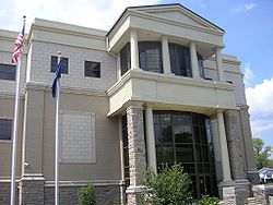
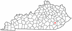
Manchester, Kentucky — City — Clay County Courthouse in Manchester, Kentucky Motto: The City of Hope Location of Manchester, Kentucky Coordinates: 37°9′10″N 83°45′48″W / 37.15278°N 83.76333°WCoordinates: 37°9′10″N 83°45′48″W / 37.15278°N 83.76333°W Country United States State Kentucky County Clay Incorporated February 6, 1844 Government - Type Mayor-Council - Mayor George Saylor Area - Total 1.5 sq mi (3.9 km2) - Land 1.5 sq mi (3.9 km2) - Water 0.0 sq mi (0.0 km2) Elevation 869 ft (265 m) Population (2000) - Total 1,738 - Density 1,148.4/sq mi (443.4/km2) Time zone Eastern (EST) (UTC-5) - Summer (DST) EDT (UTC-4) ZIP code 40962 Area code(s) 606 FIPS code 21-49656 GNIS feature ID 0513768 Manchester is a city in Clay County, Kentucky, United States. The city's population was 1,738 at the 2000 census. It is the county seat of Clay County.[1] It is also home to Federal Correctional Institution, Manchester.
Contents
Geography
Manchester is located at 37°9′10″N 83°45′48″W / 37.15278°N 83.76333°W (37.152818, -83.763403)[2].
According to the United States Census Bureau, the city has a total area of 1.5 square miles (3.9 km2), all of it land.
Demographics
Historical populations Census Pop. %± 1900 398 — 1940 1,509 — 1950 1,706 13.1% 1960 1,868 9.5% 1970 1,664 −10.9% 1980 1,838 10.5% 1990 1,634 −11.1% 2000 1,738 6.4% Est. 2009 1,973 [3] 13.5% U.S. Census Bureau[4] As of the census[5] of 2000, there were 1,738 people, 778 households, and 455 families residing in the city. The population density was 1,148.4 people per square mile (444.4/km²). There were 844 housing units at an average density of 557.7 per square mile (215.8/km²). The racial makeup of the city was 92.29% White, 6.27% African American, 0.06% Native American, 0.29% Asian, 0.06% from other races, and 1.04% from two or more races. Hispanic or Latino of any race were 0.58% of the population.
There were 778 households out of which 27.2% had children under the age of 18 living with them, 38.0% were married couples living together, 17.5% had a female householder with no husband present, and 41.4% were non-families. 39.5% of all households were made up of individuals and 19.0% had someone living alone who was 65 years of age or older. The average household size was 2.16 and the average family size was 2.89.
In the city the population was spread out with 22.6% under the age of 18, 8.9% from 18 to 24, 28.1% from 25 to 44, 22.3% from 45 to 64, and 18.1% who were 65 years of age or older. The median age was 38 years. For every 100 females there were 80.3 males. For every 100 females age 18 and over, there were 73.8 males.
The median income for a household in the city was $15,923, and the median income for a family was $25,625. Males had a median income of $23,235 versus $17,361 for females. The per capita income for the city was $13,751. About 27.0% of families and 31.6% of the population were below the poverty line, including 39.4% of those under age 18 and 20.2% of those age 65 or over.
Notable natives
- Bert T. Combs - Former governor
- Richie Farmer - Former University of Kentucky shooting guard and Kentucky Commissioner of Agriculture
- Steve Napier - Former famous clown, now life saving doctor at Manchester Hospital.
- James Paul Von Helton - Conspiracy theorist .
- Captain James F. Hensley - Korean War Hero, Viet Nam Veteran, and 2011 Inductee into the Infantry Officer Candidate School (OCS) Hall of Fame at Fort Benning, GA. His most notable combat awards and decorations include the Distinguished Service Cross (DSC) is our nations second highest award after the Congressional Medal of Honor. He received the DSC for service in Korea on December 19, 1950 as an Infantry Squad Leader (Corporal). His Distinguishd Service Cross Citation can be found at the following website:[[1]]; the Bronze Star Medal for service in Viet Nam as an Infantry Officer and Civil Affairs Officer (Captain); the Purple Heart (for wounds received from enemy action) in Viet Nam; and the Combat Infantry Badge (CIB) with star. His first CIB was awarded for Infantry Combat Action in Korea during the Korean War. His second CIB was awarded for Infantry Combat Action in Viet Nam during the Viet Nam War. He is buried close to his childhood home near Oneida, KY.
- Colonel Darryl W. Hensley - retired after 27 1/2 years of service (1983 to 2011) from the United States Army. The majority of his career was spent in the Information Warfare career field. His OPERATION ENDURING FREEDOM and OPERATION IRAQI FREEDOM combat awards include the Bronze Star Medal, the Defense Meritorious Service Medal, the Joint Service Commendation Medal, and two Joint Meritorious Unit Awards. Colonel Hensley graduated from Oneida Baptist Institute, Oneida, KY in 1979. Colonel Hensley's father Carl Hensley graduated from Oneida Baptist Institute, Oneida, KY in 1954. Carl Hensley's Father Charles Ambrose Hensley; Grandfather, John E. Hensley; Great-Grandfather Benjamin Hensley; and Great-Great Grandfather James Hensley are all buried in Clay County, Kentucky. His relative Henry B. Hensley (Big Henry), was the first contributor to Oneida Baptist Institute by donating $50.00 to James Anderson Burns, the school founder in 1899.
- Carl Hensley was featured in the Air and Space Magazine for his innovative field engineer work on the Over-the-Horizon Backscatter (OTH-B) radar transmit sites in Moscow, Maine and Christmas Valley, Oregon. Carl Hensley worked at the General Electric Aerospace Radar Design and Engineering Department in Syracuse, New York. He retired from General Electric as a Radar Technician after 32 years of service (1959-1991) and served at several remote radar sites during his distinguished career (Alaska, California, Idaho, Montana, Minnesota, Maine and Oregon). His radar system engineering contributions in North America significantly contributed to the Cold War victory.
Broadcast media
Manchester is the city of license cited by four radio stations:
References
- ^ "Find a County". National Association of Counties. http://www.naco.org/Counties/Pages/FindACounty.aspx. Retrieved 2011-06-07.
- ^ "US Gazetteer files: 2010, 2000, and 1990". United States Census Bureau. 2011-02-12. http://www.census.gov/geo/www/gazetteer/gazette.html. Retrieved 2011-04-23.
- ^ Annual Estimates of Resident Population for Incorporated Cities in Kentucky: April 1, 2000 to July 1, 2009 United States Census Bureau. Retrieved on 2010-12-16
- ^ Historical Census Data Retrieved on 2010-12-16
- ^ "American FactFinder". United States Census Bureau. http://factfinder.census.gov. Retrieved 2008-01-31.
External links
Municipalities and communities of Clay County, Kentucky City Manchester
Communities Eastern Mountain Coal Fields Counties Cities and towns
10k-25kCities and towns
5k-10kCities and towns
1k-5kBarbourville • Beattyville • Catlettsburg • Clay City • Cumberland • Elkhorn City • Evarts • Grayson • Greenup • Harlan • Hazard • Jackson • Jeffersonville • Jenkins • Louisa • Manchester • Olive Hill • Paintsville • Pineville • Prestonsburg • Raceland • Russell • Salyersville • South Shore • Stanton • West Liberty • Wheelwright • Whitesburg • Worthington • WurtlandCities and towns
under 1kAllen • Bellefonte • Benham • Blackey • Blaine • Booneville • Buckhorn • Camargo • Campton • Cedarville • Coal Run Village • Fleming-Neon • Frenchburg • Hindman • Hyden • Inez • Lakeview Heights • Loyall • Lynch • Martin • McKee • Pippa Passes • Sandy Hook • Vicco • Wallins Creek • Warfield • WaylandStatistical areas County seats in Kentucky Albany • Alexandria • Barbourville • Bardstown • Bardwell • Beattyville • Bedford • Benton • Booneville • Bowling Green • Brandenburg • Brooksville • Brownsville • Burkesville • Burlington • Cadiz • Calhoun • Campbellsville • Campton • Carlisle • Carrollton • Catlettsburg • Clinton • Columbia • Covington • Cynthiana • Danville • Dixon • Eddyville • Edmonton • Elizabethtown • Elkton • Falmouth • Flemingsburg • Frankfort • Franklin • Frenchburg • Georgetown • Glasgow • Grayson • Greensburg • Greenup • Greenville • Hardinsburg • Harlan • Harrodsburg • Hartford • Hawesville • Hazard • Henderson • Hickman • Hindman • Hodgenville • Hopkinsville • Hyden • Independence • Inez • Irvine • Jackson • Jamestown • La Grange • Lancaster • Lawrenceburg • Lebanon • Leitchfield • Lexington • Liberty • London • Louisa • Louisville • Madisonville • Manchester • Marion • Mayfield • Maysville • McKee • Monticello • Morehead • Morganfield • Morgantown • Mount Olivet • Mount Sterling • Mount Vernon • Munfordville • Murray • New Castle • Nicholasville • Owensboro • Owenton • Owingsville • Paducah • Paintsville • Paris • Pikeville • Pineville • Prestonsburg • Princeton • Richmond • Russellville • Salyersville • Sandy Hook • Scottsville • Shelbyville • Shepherdsville • Smithland • Somerset • Springfield • Stanford • Stanton • Taylorsville • Tompkinsville • Vanceburg • Versailles • Warsaw • West Liberty • Whitesburg • Whitley City • Wickliffe • Williamsburg • Williamstown • WinchesterCategories:- Cities in Kentucky
- Populated places in Clay County, Kentucky
- County seats in Kentucky
- Populated places established in 1844
Wikimedia Foundation. 2010.


