- Bell County, Kentucky
-
Bell County, Kentucky 
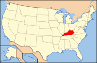
Location in the state of Kentucky
Kentucky's location in the U.S.Founded 1867 Named for Joshua Fry Bell, Kentucky legislator (1862–1867). Seat Pineville Largest city Middlesborough Area
- Total
- Land
- Water
361.35 sq mi (936 km²)
360.77 sq mi (934 km²)
0.58 sq mi (2 km²), 0.16%Population
- (2010)
- Density
28,691
83/sq mi (32/km²)Time zone Eastern: UTC-5/-4 Website www.bellcountychamber.com Bell County is a county located in the U.S. state of Kentucky. It was formed August 1, 1867, from parts of Knox and Harlan Counties[1] and augmented from Knox County in 1872.[2] As of 2010 the population was 69,060. Its county seat is Pineville.[3] The county is named for Joshua Fry Bell, and was originally called "Josh Bell" but shortened to "Bell" by 1880.[4]
Bell County is a dry county, meaning that the sale of alcohol is prohibited.
The Middlesborough, KY Micropolitan Statistical Area includes all of Bell County.
Contents
Geography
According to the 2000 census, the county has a total area of 361.35 square miles (935.9 km2), of which 360.77 square miles (934.4 km2) (or 99.84%) is land and 0.58 square miles (1.5 km2) (or 0.16%) is water.[5]
Adjacent counties
- Clay County (north)
- Leslie County (northeast)
- Harlan County (east)
- Lee County, Virginia (southeast)
- Claiborne County, Tennessee (south)
- Whitley County (southwest)
- Knox County (northwest)
National protected area
Demographics
Historical populations Census Pop. %± 1870 3,731 — 1880 6,055 62.3% 1890 10,312 70.3% 1900 15,701 52.3% 1910 28,447 81.2% 1920 33,988 19.5% 1930 38,747 14.0% 1940 43,812 13.1% 1950 47,602 8.7% 1960 35,336 −25.8% 1970 31,121 −11.9% 1980 34,330 10.3% 1990 31,506 −8.2% 2000 30,060 −4.6% 2010 28,691 −4.6% http://ukcc.uky.edu/~census/21013.txt As of the census[6] of 2000, there were 30,060 people, 12,004 households, and 8,522 families residing in the county. The population density was 83 per square mile (32 /km2). There were 13,341 housing units at an average density of 37 per square mile (14 /km2). The racial makeup of the county was 96.02% White, 2.40% Black or African American, 0.25% Native American, 0.35% Asian, 0.03% Pacific Islander, 0.12% from other races, and 0.83% from two or more races. 0.65% of the population were Hispanic or Latino of any race.
There were 12,004 households out of which 31.90% had children under the age of 18 living with them, 51.00% were married couples living together, 15.70% had a female householder with no husband present, and 29.00% were non-families. 26.80% of all households were made up of individuals and 11.40% had someone living alone who was 65 years of age or older. The average household size was 2.44 and the average family size was 2.95.
The age distribution was 24.40% under the age of 18, 9.00% from 18 to 24, 28.70% from 25 to 44, 24.20% from 45 to 64, and 13.70% who were 65 years of age or older. The median age was 37 years. For every 100 females there were 91.60 males. For every 100 females age 18 and over, there were 88.00 males.
The median income for a household in the county was $19,057, and the median income for a family was $23,818. Males had a median income of $24,521 versus $19,975 for females. The per capita income for the county was $11,526. About 26.70% of families and 31.10% of the population were below the poverty line, including 42.00% of those under age 18 and 21.80% of those age 65 or over.
Cities and towns
- Middlesborough (also spelled Middlesboro)
- Pineville
School Districts
Three public school districts operate in the county:
Bell County Schools
The largest of the three in enrollment and by far the largest in geographic scope. The district operates six mainstream K-8 "school centers", one alternative school, one vocational school, and one high school.
Middlesboro Independent Schools
The second-largest of the three, with boundaries coinciding exactly with the corporate limits of Middlesboro.[7] The district operates two elementary schools, one designated as "primary" and the other as "intermediate"; one middle school; and one high school. The two elementary schools are separate facilities that share the same campus design (both schools are designed in an "X" shape), and the middle and high schools are separate facilities on one campus on the west side of town.
Pineville Independent Schools
The county's smallest district; its boundaries generally, but do not exactly, follow the corporate limits of Pineville.[8] The district operates elementary, middle, and high schools on the same campus.
See also
- Dry county
- Hensley Settlement
- Middlesborough, KY Micropolitan Statistical Area
- National Register of Historic Places listings in Bell County, Kentucky
References
- ^ "Bell County, Kentucky" My Kentucky Genealogy. Retrieved 2010-07-06.
- ^ Census Office. Tenth Census of the United Status (1880) I:62.
- ^ "Find a County". National Association of Counties. http://www.naco.org/Counties/Pages/FindACounty.aspx. Retrieved 2011-06-07.
- ^ Census Office. op. cit.
- ^ "Census 2000 U.S. Gazetteer Files: Counties". United States Census. http://www.census.gov/tiger/tms/gazetteer/county2k.txt. Retrieved 2011-02-13.
- ^ "American FactFinder". United States Census Bureau. http://factfinder.census.gov. Retrieved 2008-01-31.
- ^ Kentucky Transportation Cabinet (1990). "Map of Middlesboro" (PDF). Kentucky Department of Revenue. http://revenue.ky.gov/NR/rdonlyres/6A3088A8-24E9-403C-AE69-0C63EBD8F9FB/0/Bell_Middlesboro_Ind.jpg. Retrieved 2007-10-06. The map also bears a handwritten 1996 label, as the district boundary was signed off by the superintendents of the Bell County and Middlesboro districts. The Middlesboro district boundary is marked in black.
- ^ Kentucky Transportation Cabinet (1989). "Map of Pineville" (PDF). Kentucky Department of Revenue. http://revenue.ky.gov/NR/rdonlyres/FE1F33F9-A462-4C8C-877F-0FF315522D9A/0/Bell_Pineville_Ind.jpg. Retrieved 2007-10-06. The map also bears a handwritten 1996 label, as the district boundary was signed off by the superintendents of the Bell County and Pineville districts. The Pineville district boundary is marked in black.
External links
- The Kentucky Highlands Project
- Bell County, Kentucky - USGenWeb
- Bell County, Kentucky - Kentucky Atlas & Gazetteer
- Bell County, Kentucky Tourism Commission
Municipalities and communities of Bell County, Kentucky Cities Eastern Mountain Coal Fields Counties Cities and towns
10k-25kCities and towns
5k-10kCities and towns
1k-5kBarbourville • Beattyville • Catlettsburg • Clay City • Cumberland • Elkhorn City • Evarts • Grayson • Greenup • Harlan • Hazard • Jackson • Jeffersonville • Jenkins • Louisa • Manchester • Olive Hill • Paintsville • Pineville • Prestonsburg • Raceland • Russell • Salyersville • South Shore • Stanton • West Liberty • Wheelwright • Whitesburg • Worthington • WurtlandCities and towns
under 1kAllen • Bellefonte • Benham • Blackey • Blaine • Booneville • Buckhorn • Camargo • Campton • Cedarville • Coal Run Village • Fleming-Neon • Frenchburg • Hindman • Hyden • Inez • Lakeview Heights • Loyall • Lynch • Martin • McKee • Pippa Passes • Sandy Hook • Vicco • Wallins Creek • Warfield • WaylandStatistical areas Categories:- Kentucky counties
- 1867 establishments
- Bell County, Kentucky
Wikimedia Foundation. 2010.

