- Graves County, Kentucky
-
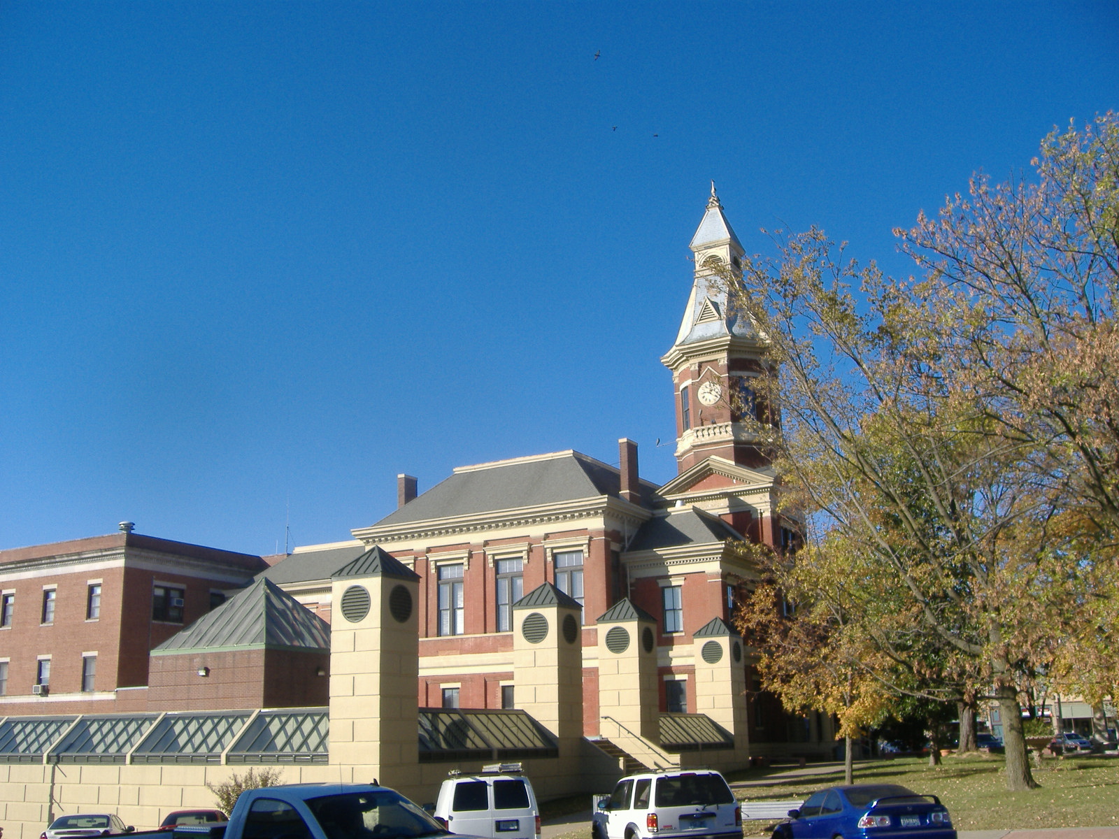
Graves County, Kentucky  Graves County Courthouse in Mayfield, Kentucky
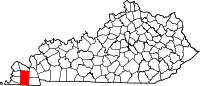
Location in the state of Kentucky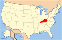
Kentucky's location in the U.S.Founded 1824 Named for Major Benjamin F. Graves (1771–1813), killed at the Battle of River Raisin. Seat Mayfield Area
- Total
- Land
- Water
556.46 sq mi (1,441 km²)
555.59 sq mi (1,439 km²)
0.87 sq mi (2 km²), 0.16%Population
- (2000)
- Density
37,028
67/sq mi (26/km²)Time zone Central: UTC-6/-5 Website www.mayfieldchamber.com Graves County is a county located in the U.S. Commonwealth of Kentucky. It was formed in 1824. As of 2000, the population was 37,028. Its county seat is Mayfield[1]. The county is named for Major Benjamin Franklin Graves, soldier in the War of 1812. The Mayfield Micropolitan Statistical Area includes all of Graves County.
Graves County is a “limited” dry county, meaning that sale of alcohol in the county is prohibited except for wine and beer in restaurants in Mayfield which have seating for at least 100 patrons or at the Mayfield Golf & Country Club.
Contents
History
As one of Kentucky's largest counties, Graves's history of legends and leaders includes a US Vice President, four US Congressmen, famous and infamous heroes, singers and songwriters, noted writers and a legacy of historic sites.
The fertile land attracted early settlers from Virginia, North Carolina, South Carolina and Tennessee, who brought with them a degree of education and culture and a fierce determination to succeed on the land. Remarkable in their achievements as craftsmen and farmers they put down roots to blend a political, economic, and social environment unique, perhaps only to Graves County.
Tobacco was very much as part of the local economy over the years and Graves County has a rich history of the dark-fired and dark-air-cured leaf tobacco used in smokeless tobacco farming. A woolen mill, began operation prior to the Civil War and continued to grow with the men's clothing market. Several clothing companies were added and the town's minor league baseball team was even called the Mayfield Clothiers.
Made national news in September 2011 for jailing Amish men who refused to use orange safety triangle on buggies. These Swartzentruber Amish used reflective tape, but refused to use the orange triangle. After the appeal of their 2008 conviction was denied, Menno Zook, Danny Byler, Mose Yoder, Levi Hotetler, David Zook and Eli Zook refused to pay the small fines associated with their conviction. All six served sentences ranging from three to 10 days in the Graves County Jail, according to the jail's website. The men were "very polite, respectful, everything you would expect," said Graves County Chief Deputy Tim Warren. He said the men dressed up in their "Sunday best" to report for their jail sentences. The men are not forced to wear the orange county jail uniforms, Warren said. They are allowed to wear uniforms that are dyed a dark gray, but they are not allowed to wear their own clothes.[2]
Geography
According to the 2000 census, the county has a total area of 556.46 square miles (1,441.2 km2), of which 555.59 square miles (1,439.0 km2) (or 99.84%) is land and 0.87 square miles (2.3 km2) (or 0.16%) is water.[3]
Adjacent counties
- McCracken County (north)
- Marshall County (northeast)
- Calloway County & Henry County, Tennessee (southeast)
- Weakley County, Tennessee (south)
- Hickman County (southwest)
- Carlisle County (northwest)
National protected area
Demographics
Historical populations Census Pop. %± 1830 2,504 — 1840 7,465 198.1% 1850 11,397 52.7% 1860 16,233 42.4% 1870 19,398 19.5% 1880 24,138 24.4% 1890 28,534 18.2% 1900 33,204 16.4% 1910 33,539 1.0% 1920 32,483 −3.1% 1930 30,778 −5.2% 1940 31,763 3.2% 1950 31,364 −1.3% 1960 30,021 −4.3% 1970 30,939 3.1% 1980 34,049 10.1% 1990 33,550 −1.5% 2000 37,028 10.4% http://ukcc.uky.edu/~census/21083.txt As of the census[4] of 2000, there were 37,028 people, 14,841 households, and 10,566 families residing in the county. The population density was 67 per square mile (26 /km2). There were 16,340 housing units at an average density of 29 per square mile (1.1×10⁻¹¹ km2). The racial makeup of the county was 92.73% White, 4.44% Black or African American, 0.20% Native American, 0.20% Asian, 0.01% Pacific Islander, 1.30% from other races, and 1.11% from two or more races. 2.40% of the population were Hispanic or Latino of any race.
There were 14,841 households out of which 31.50% had children under the age of 18 living with them, 57.90% were married couples living together, 10.00% had a female householder with no husband present, and 28.80% were non-families. 26.20% of all households were made up of individuals and 12.70% had someone living alone who was 65 years of age or older. The average household size was 2.44 and the average family size was 2.92.
In the county the population was spread out with 24.50% under the age of 18, 8.30% from 18 to 24, 27.30% from 25 to 44, 23.80% from 45 to 64, and 16.10% who were 65 years of age or older. The median age was 38 years. For every 100 females there were 95.00 males. For every 100 females age 18 and over, there were 91.50 males.
The median income for a household in the county was $30,874, and the median income for a family was $38,054. Males had a median income of $32,016 versus $20,177 for females. The per capita income for the county was $16,834. About 13.10% of families and 16.40% of the population were below the poverty line, including 21.70% of those under age 18 and 14.10% of those age 65 or over.
Cities, towns, and communities
- Feliciana
- Bell City
- Boaz
- Cuba
- Dukedom (partial)
- Folsomdale
- Hickory
- Fancy Farm
- Farmington
- Feliciana
- Kaler
- Lowes
- Lynnville
- Mayfield
- Melber
- Pottsville
- Sedalia
- Symsonia
- Viola
- Water Valley
- West Viola
- Wingo
- Dublin
Notable natives
- Lucien Anderson — U.S. Representative
- Alben W. Barkley — U.S. Representative, Senator, and Vice President
- Lon Carter Barton — Historian, state representative
- Andrew Boone — U.S. Representative
- Herschel Green - World War II flying ace in the United States Army Air Force
- Noble Jones Gregory — U.S. Representative
- William Voris Gregory — U.S. Representative
- Carroll Hubbard — U.S. Representative
- John Paul Hogan
- Bobbie Ann Mason — author
- Kevin Skinner — country singer and reality show winner
- Adrian Smith — former NBA player
- Jimmy Work-Song Writer [1]
See also
References
- ^ "Find a County". National Association of Counties. http://www.naco.org/Counties/Pages/FindACounty.aspx. Retrieved 2011-06-07.
- ^ http://religion.blogs.cnn.com/2011/09/14/amish-men-jailed-over-refusal-to-use-orange-safety-triangle-on-buggies/
- ^ "Census 2000 U.S. Gazetteer Files: Counties". United States Census. http://www.census.gov/tiger/tms/gazetteer/county2k.txt. Retrieved 2011-02-13.
- ^ "American FactFinder". United States Census Bureau. http://factfinder.census.gov. Retrieved 2008-01-31.
External links
- Graves County Schools
- Mayfield and Graves County Chamber of Commerce and Tourism
- Graves County Cluster of United Methodist Churches
- Mayfield Graves County Airport
- www.gravescountyky.com/
Municipalities and communities of Graves County, Kentucky Cities CDPs Fancy Farm | Farmington | Hickory | Lowes | Pryorsburg | Sedalia | Symsonia
Unincorporated
communitiesFootnotes ‡This populated place also has portions in an adjacent county or counties
Categories:- Kentucky counties
- Graves County, Kentucky


Wikimedia Foundation. 2010.