- Pineville, Kentucky
Infobox Settlement
official_name = Pineville, Kentucky
other_name =
native_name =
nickname =
settlement_type =City
motto =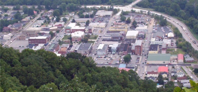
imagesize =
image_caption = Pineville, as seen from atop Pine Mountain
flag_size =
image_
seal_size =
image_shield =
shield_size =
image_blank_emblem =
blank_emblem_type =
blank_emblem_size =
mapsize = 250px
map_caption = Location of Pineville within Kentucky
mapsize1 =
map_caption1 =
image_dot_
dot_mapsize =
dot_map_caption =
dot_x =
dot_y =
pushpin_
pushpin_label_position =
pushpin_map_caption =
pushpin_mapsize =
subdivision_type = Country
subdivision_name =United States
subdivision_type1 = State
subdivision_name1 =Kentucky
subdivision_type2 = County
subdivision_name2 = Bell
government_footnotes =
government_type =
leader_title =
leader_name =
leader_title1 =
leader_name1 =
leader_title2 =
leader_name2 =
leader_title3 =
leader_name3 =
leader_title4 =
leader_name4 =
established_title =
established_date =
established_title2 =
established_date2 =
established_title3 =
established_date3 =
area_magnitude =
unit_pref = Imperial
area_footnotes =
area_total_km2 = 3.7
area_land_km2 = 3.7
area_water_km2 = 0.0
area_total_sq_mi = 1.4
area_land_sq_mi = 1.4
area_water_sq_mi = 0.0
area_water_percent =
area_urban_km2 =
area_urban_sq_mi =
area_metro_km2 =
area_metro_sq_mi =
area_blank1_title =
area_blank1_km2 =
area_blank1_sq_mi =
population_as_of = 2000
population_footnotes =
population_note =
population_total = 2093
population_density_km2 = 561.2
population_density_sq_mi = 1452
population_metro =
population_density_metro_km2 =
population_density_metro_sq_mi =
population_urban =
population_density_urban_km2 =
population_density_urban_sq_mi =
population_blank1_title =
population_blank1 =
population_density_blank1_km2 =
population_density_blank1_sq_mi =
timezone = EST
utc_offset = -5
timezone_DST = EDT
utc_offset_DST = -4
latd = 36 |latm = 45 |lats = 47 |latNS = N
longd = 83 |longm = 41 |longs = 58 |longEW = W
elevation_footnotes =
elevation_m = 309
elevation_ft = 1014
postal_code_type =ZIP code
postal_code = 40977
area_code = 606
blank_name = FIPS code
blank_info = 21-61248
blank1_name = GNIS feature ID
blank1_info = 0500726
website =
footnotes =Pineville is a city in Bell County,
Kentucky ,United States . The population was 2,093 at the 2000 census. It is thecounty seat of Bell CountyGR|6. It is located on a small strip of land between theCumberland River and Pine Mountain.It is one of the oldest settlements in Kentucky, tracing back to 1781 and a settlement called Cumberland Ford. It was part of a tract of land once owned by
Isaac Shelby , Kentucky's first governor. When Bell County was formed in 1867, Cumberland Ford was the obvious choice, but a courthouse was not completed until 1871. The settlement incorporated in 1889 as Pineville.Its riverside location has made it subject to flooding, including a devastating incident on
April 4 1977 . The 1952 floodwall was overwhelmed and 200 houses were destroyed or damaged. TheU.S. Army Corps of Engineers upgraded the floodwall in 1988.The economy is dependent on the coal mining industry and tourist at nearby
Pine Mountain State Resort Park , although there is some heavy manufacturing in the city. The population has declined from 2,817 in 1970.Geography
Pineville is located at coor dms|36|45|47|N|83|41|58|W|city (36.762932, -83.699375)GR|1.
According to the
United States Census Bureau , the city has a total area of 1.4square mile s (3.7km² ), all of it land.Demographics
As of the
census GR|2 of 2000, there were 2,093 people, 871 households, and 518 families residing in the city. Thepopulation density was 1,452.1 people per square mile (561.2/km²). There were 961 housing units at an average density of 666.7/sq mi (257.7/km²). The racial makeup of the city was 92.74% White, 4.30% African American, 0.24% Native American, 0.24% Asian, 0.14% from other races, and 2.34% from two or more races. Hispanic or Latino of any race were 0.91% of the population.There were 871 households out of which 27.6% had children under the age of 18 living with them, 34.6% were married couples living together, 20.8% had a female householder with no husband present, and 40.5% were non-families. 38.6% of all households were made up of individuals and 20.1% had someone living alone who was 65 years of age or older. The average household size was 2.17 and the average family size was 2.90.
In the city the population was spread out with 22.5% under the age of 18, 8.6% from 18 to 24, 24.2% from 25 to 44, 24.9% from 45 to 64, and 19.8% who were 65 years of age or older. The median age was 40 years. For every 100 females there were 82.0 males. For every 100 females age 18 and over, there were 76.1 males.
The median income for a household in the city was $12,435, and the median income for a family was $20,625. Males had a median income of $24,125 versus $23,229 for females. The
per capita income for the city was $12,692. About 37.1% of families and 44.2% of the population were below thepoverty line , including 58.8% of those under age 18 and 30.0% of those age 65 or over.References
External links
Wikimedia Foundation. 2010.