- Columbia, Kentucky
-
 City of Columbia, Kentucky
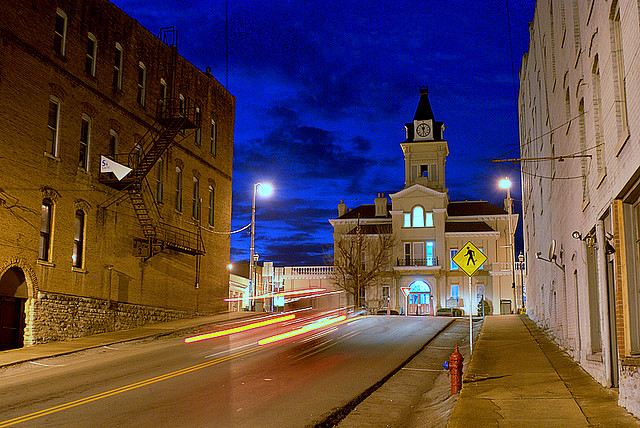
— City — Adair County Courthouse: A Local Landmark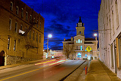 Location of Columbia, Kentucky
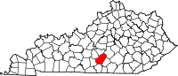
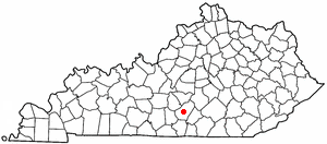
Coordinates: 37°6′2″N 85°18′22″W / 37.10056°N 85.30611°WCoordinates: 37°6′2″N 85°18′22″W / 37.10056°N 85.30611°W Country United States State Kentucky County Adair Government - Type Mayor-Council - Mayor Patrick R. Bell - City Attorney Marshall Loy - Governing body Columbia Council Area - Total 3.4 sq mi (8.9 km2) - Land 3.4 sq mi (8.9 km2) - Water 0.0 sq mi (0.0 km2) Elevation 748 ft (228 m) Population - Total 4,014 Time zone Central (CST) (UTC-6) - Summer (DST) CDT (UTC-5) ZIP codes 42715, 42728, 42735 Area code(s) 270 FIPS code 21-16750 GNIS feature ID 0489885 Columbia is a city in Adair County, Kentucky, United States, just above Russell Creek. The area was settled around 1802 by Daniel Trabue. The post office was opened on April 1, 1806 by John Field, who also ran a local store. The population was 4,014 at the 2000 census. It is the county seat of Adair County[1]. For the origin of the name see Columbia.
The Louie B. Nunn Cumberland Parkway runs through Columbia as it extends from Bowling Green, KY to Somerset, KY. This Parkway is a future Corridor of Interstate 66. The addition of an interchange with a 2006 reconstruction of Highway 61 South, Columbia now has two exits on the Parkway.
Exit 49, the original exit on the parkway, merges onto Highway 55 South (also known as Jamestown Street) bringing drivers through the middle of Columbia.
Exit 47, the new exit, merges onto Highway 61 South (also known as Burkesville Street/Road) and drivers can choose to go north and visit the new Holladay Place Shopping Center, home of Columbia's Super Wal-Mart or go to Burkesville to the south.
The Highway 55 Bypass was officially opened on October 7, 2008, for more information see below.
Columbia is also the home of Lindsey Wilson College, a private four year college.
Contents
Geography
Columbia is located at 37°6′2″N 85°18′22″W / 37.10056°N 85.30611°W (37.100652, -85.306056)[2].
According to the United States Census Bureau, the city has a total area of 3.4 square miles (8.8 km2), all land. Official revisions have been made to the total area of the city as at least eight annexations have occurred since November 4, 2004.
Demographics
As of the census[3] of 2000, there were 4,014 people, 1,554 households, and 893 families residing in the city. The population density was 1,167.9 people per square mile (450.5/km²). There were 1,789 housing units at an average density of 520.5 per square mile (200.8/km²). The racial makeup of the city was 90.38% White, 7.37% African American, 0.22% Native American, 0.60% Asian, 0.02% Pacific Islander, 0.20% from other races, and 1.20% from two or more races. Hispanic or Latino of any race were 1.02% of the population.
There were 1,554 households out of which 24.8% had children under the age of 18 living with them, 39.9% were married couples living together, 14.5% had a female householder with no husband present, and 42.5% were non-families. 40.3% of all households were made up of individuals and 22.1% had someone living alone who was 65 years of age or older. The average household size was 2.12 and the average family size was 2.84.
In the city the population was spread out with 18.0% under the age of 18, 19.1% from 18 to 24, 23.1% from 25 to 44, 19.1% from 45 to 64, and 20.6% who were 65 years of age or older. The median age was 36 years. For every 100 females there were 83.8 males. For every 100 females age 18 and over, there were 78.6 males.
The median income for a household in the city was $22,861, and the median income for a family was $31,344. Males had a median income of $23,906 versus $21,000 for females. The per capita income for the city was $17,836. About 19.9% of families and 26.6% of the population were below the poverty line, including 39.4% of those under age 18 and 17.9% of those age 65 or over.
Education
Schools in Columbia include:
- Adair County Elementary School (Kindergarten, 1st, 2nd, 3rd, 4th, 5th, & 6th Grade Students from County)
- Colonel William Casey School ( Pre-school, Kindergarten, 1st,& 2nd Grade Students from City)
- John Adair Intermediate School (3rd, 4th, & 5th Grade Students from City)
- Adair County Middle School (7th, & 8th Grade Students)
- Adair County High School (9th-12 Grade Students)
The higher education presence is Lindsey Wilson College.
Events
Events held in Columbia, Kentucky:
- Downtown Days, two-day festival on the streets of downtown Columbia. The event includes a parade, a beauty pageant, reenactment of the James/Younger Bank of Columbia robbery, 5-K run, pet show, train rides for the kids, kids carnival, face painting, inflatables, live entertainment, food, fun, clowns, choirs, and more.
Media
Media in Columbia, KY, include:
- The Adair Progress, a local 2x weekly newspaper
- WHVE, a contemporary radio station
- WAIN, a country radio station
- Adair County Community Voice, a local once weekly newspaper complete with Public Records information
- Columbia Magazine, an online-only magazine updated daily with local news and history.
Columbia Bypass
After years of promises by various Governors and other Kentucky Officials, Governor Ernie Fletcher finally made construction of the Columbia Bypass a reality. Construction began early in May 2007, which culminated in an official ground breaking ceremony by the former Governor himself on May 15, 2007 [1] near the front of the newly constructed Adair County Elementary School, which faces the direction of the bypass.
The Columbia Bypass was opened to the public on October 7, 2008 featuring a traffic light at the intersection of the bypass and North 55 as well as a traffic light at the intersection of South 61. The bypass has relieved a majority of the downtown traffic, the purpose of it being built in the first place.
Notable residents
- Damon E. Allen - Columbia optometrist who led the move to permit optometrists to prescribe medication to their patients
- Ben Arnold - inventor of the Phantom, a medical bone density measurement device used in diagnosis of osteoporosis
- Elizabeth Arnold - Miss Kentucky (2002)
- Steve Hamilton- Major League Baseball pitcher (1935-1997)
- Vernie McGaha - Kentucky state senator from Adair County since 1997
- Marine Sergeant Dakota Meyer - In September 2011, he received the Medal of Honor from President Barack Obama at age 23; he saved numerous American and Afghan troops during a Taliban ambush and is the third living recipient of the honor (and first living Marine) from the Iraq and Afghan wars
- Doug Moseley - United Methodist clergyman and a member of the Kentucky State Senate from 1974–1987; former Columbia resident
- Frank Lane Wolford - U.S. Congressman (1883–1887)
Popular culture
Columbia, Kentucky was depicted in the film Resurrection Mary starring Wilford Brimley in 2002. The film was directed by another Columbia native, Matthew Eric Arnold as part of the USC School of Cinematic Arts graduate thesis program and won awards at the Big Bear Lake International Film Festival. The filming was featured on local news stations and in USA Today.
References
- ^ "Find a County". National Association of Counties. http://www.naco.org/Counties/Pages/FindACounty.aspx. Retrieved 2011-06-07.
- ^ "US Gazetteer files: 2010, 2000, and 1990". United States Census Bureau. 2011-02-12. http://www.census.gov/geo/www/gazetteer/gazette.html. Retrieved 2011-04-23.
- ^ "American FactFinder". United States Census Bureau. http://factfinder.census.gov. Retrieved 2008-01-31.
- Resurrection Mary at IMDB
External links
Municipalities and communities of Adair County, Kentucky County seat: ColumbiaCity Columbia
Unincorporated
communitiesAbsher | Barnett Springs | Bliss | Breeding | Cane Valley | Casey Creek | Chance | Christine | Coburg | Craycraft | Crocus‡ | Cundiff | Dunbar Hill | Ella | Eunice | Fairplay | Feathersburg | Flatwood | Gadberry | Garlin | Gentrys Mill | Glens Fork | Gradyville | Holmes | Inroad | Joppa | Kellyville | Keltner | Knifley | Milltown | Montpelier | Neatsville | Nell | Ozark | Pellyton | Pickett | Portland | Purdy | Sparksville | Toria | Weed
Footnotes ‡This populated place also has portions in an adjacent county or counties.
Categories:- Populated places in Adair County, Kentucky
- Cities in Kentucky
- County seats in Kentucky
- Populated places established in 1802

Wikimedia Foundation. 2010.