- Montpelier, Kentucky
-
Montpelier — Unincorporated community — Location within the state of Kentucky
 Montpelier
Coordinates: 37°1′8″N 85°11′8″W / 37.01889°N 85.18556°WCoordinates: 37°1′8″N 85°11′8″W / 37.01889°N 85.18556°W Country United States State Kentucky County Adair Elevation 876 ft (267 m) Time zone Central (CST) (UTC-6) – Summer (DST) CDT (UTC-5) ZIP codes FIPS code GNIS feature ID 508630 Montpelier is an unincorporated community in Adair County, Kentucky, United States. Its elevation is 876 feet (267 m).[1]
References
Municipalities and communities of Adair County, Kentucky City 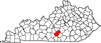
Unincorporated
communitiesAbsher | Barnett Springs | Bliss | Breeding | Cane Valley | Casey Creek | Chance | Christine | Coburg | Craycraft | Crocus‡ | Cundiff | Dunbar Hill | Ella | Eunice | Fairplay | Feathersburg | Flatwood | Gadberry | Garlin | Gentrys Mill | Glens Fork | Gradyville | Holmes | Inroad | Joppa | Kellyville | Keltner | Knifley | Milltown | Montpelier | Neatsville | Nell | Ozark | Pellyton | Pickett | Portland | Purdy | Sparksville | Toria | Weed
Footnotes ‡This populated place also has portions in an adjacent county or counties.
Categories:- Populated places in Adair County, Kentucky
- Unincorporated communities in Kentucky
- Kentucky geography stubs


Wikimedia Foundation. 2010.