- Mount Washington, Kentucky
-
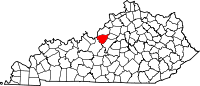
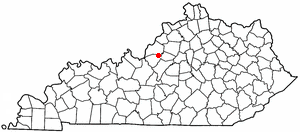
Mount Washington, Kentucky — City — Location of Mount Washington, Kentucky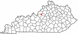
Coordinates: 38°2′46″N 85°33′17″W / 38.04611°N 85.55472°WCoordinates: 38°2′46″N 85°33′17″W / 38.04611°N 85.55472°W Country United States State Kentucky County Bullitt Area – Total 5.3 sq mi (13.8 km2) – Land 5.3 sq mi (13.8 km2) – Water 0.0 sq mi (0.0 km2) Elevation 705 ft (215 m) Population (2000) – Total 13,598 – Density 1,588.8/sq mi (613.4/km2) Time zone Eastern (EST) (UTC-5) – Summer (DST) EDT (UTC-4) ZIP code 40047 Area code(s) 502 FIPS code 21-54228 GNIS feature ID 0498905 Website http://www.mtwky.org/ Mount Washington is a city in northeast Bullitt County, Kentucky, United States. The population was 8,485 at the 2000 census. The estimated population as of 2006 was 11,761. It is located at what was once the crossroads of two stagecoach routes, which spurred early population growth and the incorporation in 1822 of a town called Mt. Vernon, after George Washington's home. The name was changed to Mount Washington in 1833 to avoid confusion with Mount Vernon in Rockcastle County.
The city is one of several surrounding Louisville, Kentucky that have experienced a sharp rise in population in the past two decades, becoming a commuter town.
Contents
History
Mount Washington was founded in the early nineteenth century and was known then as The Cross Roads. It was officially chartered in 1822 as Mount Vernon, but when a post office was applied for, it was discovered that a city in Rockcastle County was already using the name. In 1822 the city of Mt. Washington contained three churches, two schools, six stores and groceries, five doctors, two taverns and twelve mechanical trades. The population at that time was aprox. 700.
Mount Washington became the economic center of Bullitt County by the 1850s. In the Autumn of 1862, the town was held by John Wharton's Confederate cavalry, who skirmished with Maj. Gen. Thomas L. Crittenden's men north of Mount Washington along Floyds Fork on October 1. A defeat the following day lead to a Confederate retreat from the area.
Through the nineteenth century a two room school building stood on the southern end of Highway 31E, but in 1916, a new building consisting of four classrooms was built. Where the four room classroom building once stood, now stands Mt. Washington Middle School. Mt. Washington Middle School (MWMS) was built in the early 1940s and at that time was the High School. MWMS had to expand and remodel in 1995 because the population was growing tremendously, and now supports over 200 classrooms and offices. So much, that another middle school had to be built on the other side of the city. That project was completed in 2006.
Mount Washington's industries aged and by the 1930s it was no longer the most prominent town in the county. The decline continued when fire burned much of the business district on November 18, 1940. Mount Washington enjoyed an influx of new residents starting in the late 1960s with the opening of General Electric's Appliance Park nearby. The population grew from 2,020 in 1970 to over 8,000 by the 2000 census. This trend continues today despite a downturn at the Appliance Park, and the area is commonly recognized as a commuter town in regards to Louisville.
Main article: Strip search prank call scamThe events of the final call of the Strip search prank call scam took place in Mt. Washington in 2004. The local police department charged David Stewart with the crime, however he was acquitted in 2006.
The previous Mayor of Mt. Washington was a contestant on The Price is Right, playing the Money Game and winning $185 (but losing a PT Cruiser). Before the game, the mayor presented the key to the city to Bob Barker.
Historic Homes
Three homes in Mt. Washington are listed on the National Register of Historic Places.[1] Of particular note is the Lloyd House, which is in the care of the Mount Washington Historical Society and is currently being renovated to become a historical museum of the city.
- James M. Lloyd House
- Henry J. Barnes House
- Zack Stansbury House
Geography
Mount Washington is located at 38°2′46″N 85°33′17″W / 38.04611°N 85.55472°W (38.045982, -85.554676)[2].
According to the United States Census Bureau, the city has a total area of 5.3 square miles (13.8 km²), all of it land.
Demographics
Historical populations Census Pop. %± 1860 473 — 1870 340 −28.1% 1880 387 13.8% 1890 327 −15.5% 1900 1,093 234.3% 1960 1,173 — 1970 2,020 72.2% 1980 3,977 96.9% 1990 5,226 31.4% 2000 8,485 62.4% Est. 2008 11,980 [3] 41.2% Population for incorporated years[4] As of the census[5] of 2000, there were 8,485 people, 3,111 households, and 2,445 families residing in the city. The population density was 1,588.8 people per square mile (613.5/km²). There were 3,294 housing units at an average density of 616.8 per square mile (238.2/km²). The racial makeup of the city was 98.26% White, 0.32% African American, 0.32% Native American, 0.15% Asian, 0.27% from other races, and 0.68% from two or more races. Hispanics or Latinos of any race were 0.58% of the population.
There were 3,111 households out of which 43.8% had children under the age of 18 living with them, 62.3% were married couples living together, 12.2% had a female householder with no husband present, and 21.4% were non-families. 17.7% of all households were made up of individuals and 5.3% had someone living alone who was 65 years of age or older. The average household size was 2.69 and the average family size was 3.03.
The age distribution was 29.0% under 18, 8.9% from 18 to 24, 34.8% from 25 to 44, 18.6% from 45 to 64, and 8.7% who were 65 or older. The median age was 32 years. For every 100 females there were 91.9 males. For every 100 females age 18 and over, there were 90.0 males.
The median income for a household in the city was $43,813, and the median income for a family was $46,507. Males had a median income of $35,439 versus $23,600 for females. The per capita income for the city was $18,495. About 5.9% of families and 7.9% of the population were below the poverty line, including 11.8% of those under age 18 and 7.8% of those age 65 or over.
Infrastructure
Education
Mount Washington is served by the Bullitt County Public Schools. There are four elementary schools, two middle schools, and one high school within the city limits. A new elementary school is currently under construction.
There are no colleges or universities in Mt. Washington.
Elementary Schools
- Old Mill Elementary School
- Mount Washington Elementary School
- Pleasant Grove Elementary School
- Crossroads Elementary School
Middle Schools
- Mount Washington Middle School
- Eastside Middle School
High School
Transportation
The primary method of transportation in Mt. Washington is by road. Formerly named The Crossroads, Kentucky Route 44 and US Route 31E intersect in the heart of the city. A bypass on the east end of the town creates a second north-south route through the town.
References
- ^ "National Register Information System - Bullitt County, KY". National Register of Historic Places. National Park Service. 2010-04-30. http://www.nationalregisterofhistoricplaces.com/KY/Bullitt/state.html.
- ^ "US Gazetteer files: 2010, 2000, and 1990". United States Census Bureau. 2011-02-12. http://www.census.gov/geo/www/gazetteer/gazette.html. Retrieved 2011-04-23.
- ^ KSDC 2008 City Population Estimates Retrieved on 2010-2-12
- ^ Census Bureau Retrieved on 2010-2-12
- ^ "American FactFinder". United States Census Bureau. http://factfinder.census.gov. Retrieved 2008-01-31.
Municipalities and communities of Bullitt County, Kentucky Cities Fox Chase | Hebron Estates | Hillview | Hunters Hollow | Lebanon Junction | Mount Washington | Pioneer Village | Shepherdsville
CDP Community Louisville, Kentucky • Portal Subject areas Attractions/Events • Cityscape • Economy • Education • Geography • Government • History • Media • Neighborhoods • Parks • People • Performing arts • Sports • Transportation
Top subjects National
Historic
LandmarksProminent suburbs
(over 10K pop.)Bardstown • Clarksville • Jeffersontown • Jeffersonville • Mount Washington • New Albany • St. Matthews • Shelbyville • Shepherdsville • Shively50 most populous cities of Kentucky - Mount Washington
- Shelbyville
- Bardstown
- Campbellsville
- Lyndon
- Mayfield
- Lawrenceburg
- Middlesboro
- Oak Grove
- Shepherdsville
Categories:- Populated places in Bullitt County, Kentucky
- Cities in Kentucky
- Louisville metropolitan area


Wikimedia Foundation. 2010.