- New York State Route 83
-
NYS Route 83
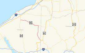
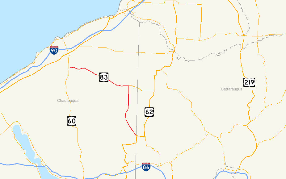
Map of Cattaraugus and Chautauqua Counties with NY 83 highlighted in redRoute information Maintained by NYSDOT Length: 21.82 mi[2] (35.12 km) Existed: 1930[1] – present Major junctions South end:  US 62 in Ellington
North end:  NY 60 in Pomfret
Location Counties: Chautauqua Highway system Numbered highways in New York
Interstate • U.S. • N.Y. (former) • Reference • County←  NY 82
NY 82I-84  →
→New York State Route 83 (NY 83) is a state route located entirely in Chautauqua County, New York in the United States. It extends from an intersection with U.S. Route 62 (US 62) in the hamlet of Conewango Valley (at the Cattaraugus County border) to NY 60 in the hamlet of Laona, near Fredonia. Along the way, NY 83 intersects with NY 322 at Balcom Corners and serves the village of Cherry Creek.
NY 83 initially extended south to Frewsburg when it was assigned as part of the 1930 renumbering. The portion of the route between Frewsburg and Conewango Valley became part of US 62 ca. 1932, resulting in the truncation of NY 83 to its current southern terminus in the 1940s.
Contents
Route description
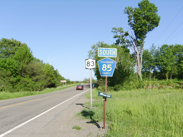
 These signposts in Arkwright show CR 85 running concurrently with NY 83.
NY 83 begins at US 62 in the hamlet of Conewango Valley, located in the northeastern corner of the town of Ellington. The route heads north-northwestward, paralleling a pair of train tracks, and shortly after enters the village of Cherry Creek, where it intersects County Route 70 (CR 70) and CR 68, respectively. Known as Main Street, it bows out to the east slightly, and subsequently takes on a due north path as it heads through the town of Cherry Creek. A couple miles later, it reaches the hamlet of Balcom Corners (located in the town of Villenova), a community situated at the junction of NY 83 and the western terminus of NY 322. Here, NY 83 turns westward toward the community of Hamlet, where it intersects with CR 72.[3]
NY 83 begins a more erratic routing, passing between West Mud Lake and Black Pond as it enters the town of Arkwright. For a short distance it is concurrent with CR 85, and takes on the name Black Corner Street, so named because it is located within the hamlet of Black Corners.[4] Although this portion of NY 83 is cosigned with CR 85, it is maintained by the New York State Department of Transportation.[5] An intersection with CR 79 is not far off, as it passes just north of the town of Arkwright. NY 83 proceeds west-northwest until it reaches its ending terminus at NY 60 in the community of Laona, located just west of the Arkwright town line in Pomfret.[4]
History
NY 83 was assigned as part of the 1930 renumbering of state highways in New York to an alignment extending from Frewsburg in the south to Laona in the north.[1] US 62 was extended into New York ca. 1932, overlapping NY 83 from Frewsburg to Conewango Valley.[6][7] The overlap was eliminated in the 1940s when NY 83 was truncated to its junction with US 62 in Conewango Valley.[8][9]
Major intersections
The entire route is in Chautauqua County.
Location Mile[2] Destinations Notes Ellington 0.00 US 62Hamlet of Conewango Valley Villenova 9.62  NY 322
Hamlet of Balcom Corners; western terminus of NY 322 Pomfret 21.82 NY 60Hamlet of Laona 1.000 mi = 1.609 km; 1.000 km = 0.621 mi References
- ^ a b Automobile Legal Association (ALA) Automobile Green Book, 1930/31 and 1931/32 editions, (Scarborough Motor Guide Co., Boston, 1930 and 1931). The 1930/31 edition shows New York state routes prior to the 1930 renumbering
- ^ a b "2008 Traffic Data Report for New York State" (PDF). New York State Department of Transportation. June 16, 2009. p. 218. https://www.nysdot.gov/divisions/engineering/technical-services/hds-respository/NYSDOT_Traffic_Data_Report_2008.pdf. Retrieved December 8, 2009.
- ^ Google, Inc. Google Maps – first overview map of NY 83 (Map). Cartography by Google, Inc. http://maps.google.com/maps?hl=en&q=from:+RT-83%20@42.242190,%20-79.062400+to:+RT-83%20@42.388149,%20-79.168314. Retrieved May 3, 2008.
- ^ a b Google, Inc. Google Maps – second overview map of NY 83 (Map). Cartography by Google, Inc. http://maps.google.com/maps?hl=en&q=from:+RT-83%20@42.388149,%20-79.168314+to:+RT-83%20@42.413378,%20-79.304593. Retrieved May 2, 2008.
- ^ New York State Department of Transportation (1978). Forestville Digital Raster Quadrangle (Map). 1:24,000. http://www.nysgis.state.ny.us/gisdata/quads/drg24/dotpreview/index.cfm?code=u5. Retrieved January 20, 2010.
- ^ Kendall Refining Company (1931). New York (Map). Cartography by H.M. Gousha Company.
- ^ Texas Oil Company (1932). Texaco Road Map – New York (Map). Cartography by Rand McNally and Company.
- ^ Gulf Oil Company (1940). New York Info-Map (Map). Cartography by Rand McNally and Company.
- ^ Texaco (1946). New York with Pennsylvania (Map). Cartography by Rand McNally and Company.
External links
Categories:- State highways in New York
- Transportation in Chautauqua County, New York

Wikimedia Foundation. 2010.