- New York State Route 82
-
NYS Route 82
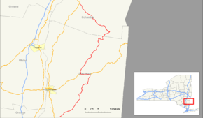
Map of the Mid-Hudson Valley with NY 82 highlighted in redRoute information Maintained by NYSDOT Length: 59.91 mi[2] (96.42 km) Existed: 1930[1] – present Major junctions South end:  NY 52 near Fishkill village
 Taconic Parkway in East Fishkill
 US 44 in Millbrook
US 44 in Pleasant Valley
Taconic Parkway in TaghkanicNorth end: 

 US 9 / NY 9H / NY 23 in Livingston
Location Counties: Dutchess, Columbia Highway system Numbered highways in New York
Interstate • U.S. • N.Y. (former) • Reference • County←  NY 81
NY 81NY 83  →
→New York State Route 82 (NY 82) is a state highway in the eastern Hudson Valley of New York, United States. It begins at an intersection with NY 52 northeast of the village of Fishkill, bends eastward towards Millbrook, and then returns westward to end at a junction with U.S. Route 9, NY 9H, and NY 23 at Bell Pond, near Claverack. NY 82 meets the Taconic State Parkway twice; it is the only state highway that has more than one exit with the parkway. The road spans two counties: Dutchess and Columbia.
NY 82 was assigned as part of the 1930 renumbering of state highways in New York. An alternate route of NY 82 from South Millbrook to Pine Plains, designated as New York State Route 82A, was assigned at the same time. Part of NY 82A was replaced by the new U.S. Route 44 ca. 1935. The routings of NY 82 and NY 82A were swapped in the mid-1930s, but the change was reverted in the mid-1960s. Ownership and maintenance of NY 82A was transferred from the state of New York to Dutchess County in 1980, at which time it was redesignated as County Route 83.
Contents
Route description
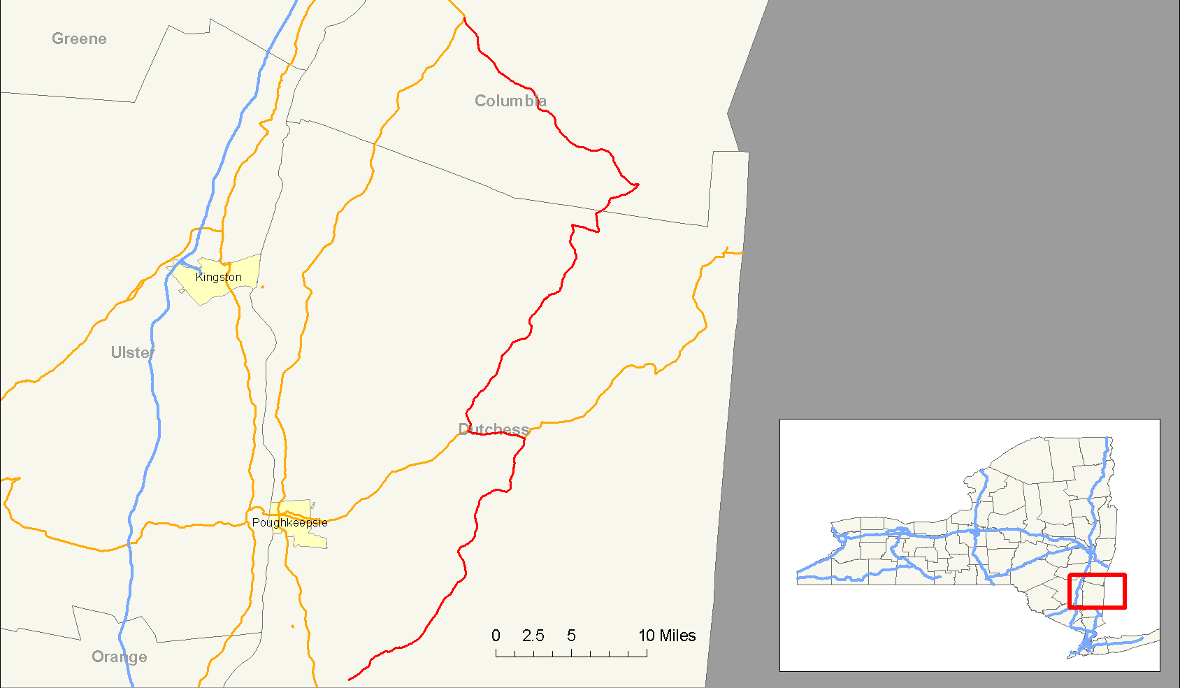
Dutchess County
NY 82 begins at an intersection with NY 52 in Brinckerhoff. The route proceeds to the northeast, paralleling the path of the Fishkill Creek through southern Dutchess County. At the East Fishkill hamlet of Hopewell Junction, NY 82 briefly overlaps NY 376 before separating from the waterway east of the hamlet. NY 82 continues north to the community of Arthursburg, where it meets the Taconic State Parkway at an interchange. Past the exit, the two roads begin to follow parallel routings through the center of the county. To the north in Billings, NY 82 intersects NY 55 before continuing onward toward the village of Millbrook. South of Millbrook, NY 82 turns to the west at an intersection with NY 343. Midway between Millbrook and the Taconic Parkway, NY 82 meets U.S. Route 44 and overlaps the route for a short distance to the west. The two routes separate just east of where US 44 meets the parkway.[3]
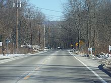 NY 82 looking south, near Millbrook
North of the split with US 44, NY 82 passes through the former hamlet of Bloomvale. It then leaves the vicinity of the parkway and begins to parallel Wappinger Creek as it heads through the northern extent of Dutchess County. At Pine Plains, the creek terminates while NY 82 intersects NY 199 in the center of the hamlet. NY 82 turns east, forming a brief overlap with NY 199 before splitting outside of the community. Shortly after leaving NY 199, NY 82 passes into Columbia County.[3]
Columbia County
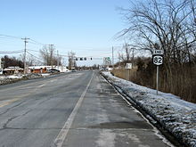
 Signage for NY 82 near Millbrook
Within Columbia County, NY 82 maintains a predominantly northwest–southeast routing. From the county line northward, NY 82 passes through Ancramdale and Ancram prior to meeting the Taconic Parkway a second time near the Lake Taghkanic State Park in West Taghkanic. Past the Taconic, NY 82 continues onward to Bell Pond, where it terminates at an intersection with U.S. Route 9, NY 9H, and NY 23.[3]
History
Origins and establishment
In 1908, the New York State Legislature created Route 1, an unsigned legislative route extending from New York City to Rensselaer. Route 1 left modern NY 22 at the hamlet of Amenia and followed what is now U.S. Route 44 west to Smithfield Valley Road. From there, the route headed north through the town of North East and northwest through the town of Pine Plains to the community of Pine Plains by way of Smithfield Valley Road. Route 1 continued northward on Silvernails and Gallatinville Roads and modern County Route 7 to the hamlet of Ancram, where it turned northeast to follow today's CR 7 toward Copake.[4][5] On March 1, 1921, Route 1 was realigned between Amenia and Copake to use modern NY 22 instead.[6]
 NY 82's northern terminus at US 9, NY 23 and NY 9H in Bell Pond.
In the 1930 renumbering of state highways in New York, the portion of pre-1921 legislative Route 1 between Pine Plains and Ancram became part of NY 82, a new route extending from the vicinity of the village of Fishkill in the south to the town of Livingston in the north.[1][7] At the same time, the segment of old Route 1 from Amenia to Pine Plains became part of NY 82A, an alternate route of NY 82 between the hamlets of South Millbrook and Pine Plains by way of Amenia.[1]
Realignments and maintenance transfers
Ca. 1935, the portions of NY 82 and NY 82A between Washington's Hollow and Amenia were incorporated into the new US 44. As a result, NY 82A was truncated to begin at US 44 near Amenia while NY 82 overlapped US 44 from South Millbrook to Washington's Hollow.[8][9] The routings of NY 82 and NY 82A between South Millbrook and Pine Plains were swapped ca. 1936, with the route via Amenia becoming NY 82 and the route via Stanford becoming NY 82A. From South Millbrook to Amenia, NY 82 overlapped US 44.[9][10]
NY 82 has been realigned twice between Pine Plains and Ancram since its assignment. Ca. 1935, the route was altered to bypass Gallatinville Road and continue on Silvernails Road to the hamlet of Silvernails, where it met modern County Route 7.[8][9] In the early 1950s, NY 82 was changed to exit Pine Plains to the east by way of an overlap with NY 199. At Hammertown, the two routes split and NY 82 continued north to Ancram by way of Ancramdale. Between Ancramdale and Ancram, NY 82 replaced NY 201,[11][12] a route originally assigned as part of the 1930 renumbering.[7]
In the mid-1960s, NY 82 and NY 82A were restored to their ca. 1935 alignments, with NY 82 routed through Washington's Hollow and NY 82A beginning in Amenia.[13][14] On April 1, 1980, ownership and maintenance of NY 82A was transferred from the state of New York to Dutchess County as part of a highway maintenance swap between the two levels of government. Also transferred from the state to the county was the portion of NY 82's original routing in Pine Plains between NY 199 and Silvernails Road.[15] Following the swap, NY 82A was redesignated as County Route 83 while NY 82's former routing in Pine Plains became CR 83A.[16]
As part of the above highway maintenance swap, the state assumed maintenance of the portion of NY 82 from NY 199 to the Columbia County line. At the same time, the state also acquired ownership of the segment of NY 82 in Columbia County between the Dutchess County line and CR 7 in Ancram as part of a separate swap with Columbia County. Both segments had previously been county-maintained.[15]
NY 82 originally entered the hamlet of South Millbrook instead of bypassing it to the west. Its former routing into the community is now County Route 111 and known as "Old Route 82".[17]
Major intersections
County Location Mile[2] Destinations Notes Dutchess Town of Fishkill 0.00 NY 52Hamlet of Brinckerhoff East Fishkill 4.24  NY 376 south
Hamlet of Hopewell Junction; western terminus of NY 82 / NY 376 overlap 4.30 NY 376 northHamlet of Hopewell Junction; eastern terminus of NY 82 / NY 376 overlap 7.83 Taconic ParkwayHamlet of Arthursburg; grade-separated interchange La Grange 11.35  NY 55
NY 55Hamlet of Billings Millbrook 20.24  NY 343
Western terminus of NY 343 22.13 US 44 eastEastern terminus of US 44 / NY 82 overlap Pleasant Valley 23.17 US 44 westHamlet of Washington's Hollow; western terminus of US 44 / NY 82 overlap Pine Plains 38.91  NY 199 west
Western terminus of NY 82 / NY 199 overlap 40.34 NY 199 eastEastern terminus of NY 82 / NY 199 overlap Columbia Taghkanic 55.07 Taconic ParkwayGrade-separated interchange Livingston 59.91 US 9 / NY 9H / NY 23Southern terminus of NY 9H 1.000 mi = 1.609 km; 1.000 km = 0.621 mi References
- ^ a b c Automobile Legal Association (ALA) Automobile Green Book, 1930–31 and 1931–32 editions, (Scarborough Motor Guide Co., Boston, 1930 and 1931). The 1930–31 edition shows New York state routes prior to the 1930 renumbering
- ^ a b "2008 Traffic Volume Report for New York State" (PDF). New York State Department of Transportation. June 16, 2009. pp. 137–138. https://www.nysdot.gov/divisions/engineering/technical-services/hds-respository/NYSDOT%20TVR%202008%20by%20Route.pdf. Retrieved January 31, 2010.
- ^ a b c Google, Inc. Google Maps – Map of NY 82 (Map). Cartography by Google, Inc. http://maps.google.com/maps?f=d&source=s_d&saddr=NY-82+N&daddr=NY-82+N+to:NY-82+N+to:42.174496,-73.75857&geocode=FdDreQIduNSY-w%3BFSbtewId5pea-w%3BFXr1gQIdf-ab-w%3B&hl=en&mra=dme&mrcr=1&mrsp=3&sz=17&via=1&sll=42.175975,-73.756531&sspn=0.004341,0.011362&ie=UTF8&ll=41.788721,-73.44223&spn=0.559068,1.454315&z=10. Retrieved January 10, 2010.
- ^ State of New York Department of Highways (1909). The Highway Law. Albany, New York: J. B. Lyon Company. p. 53. http://books.google.com/books?id=jZ0AAAAAMAAJ&pg=PA53. Retrieved July 14, 2009.
- ^ New York State Department of Highways (1920). Report of the State Commissioner of Highways. Albany, New York: J. B. Lyon Company. p. 496. http://books.google.com/books?id=Sj4CAAAAYAAJ&pg=PA496. Retrieved July 14, 2009.
- ^ New York State Legislature (1921). "Tables of Laws and Codes Amended or Repealed". Laws of the State of New York passed at the One Hundred and Forty-Fourth Session of the Legislature. Albany, New York: J. B. Lyon Company. pp. 42–44. http://books.google.com/books?id=6pE4AAAAIAAJ&pg=PA42. Retrieved May 10, 2010.
- ^ a b Standard Oil Company of New York (1930). Road Map of New York (Map). Cartography by General Drafting.
- ^ a b Texas Oil Company (1934). Road Map of New York (Map). Cartography by Rand McNally and Company.
- ^ a b c Sun Oil Company (1935). Road Map & Historical Guide – New York (Map). Cartography by Rand McNally and Company.
- ^ Standard Oil Company (1936). New York (Map). Cartography by General Drafting.
- ^ Sunoco (1952). New York (Map). Cartography by Rand McNally and Company.
- ^ Esso (1954). New York with Special Maps of Putnam–Rockland–Westchester Counties and Finger Lakes Region (Map). Cartography by General Drafting (1955–56 ed.).
- ^ Sinclair (1964). New York and Metropolitan New York (Map). Cartography by Rand McNally and Company.
- ^ Esso (1968). New York (Map). Cartography by General Drafting (1969–70 ed.).
- ^ a b New York State Legislature. "New York State Highway Law § 341". http://public.leginfo.state.ny.us/menugetf.cgi?COMMONQUERY=LAWS. Retrieved July 14, 2009.
- ^ New York State Department of Transportation (1989). Pine Plains Digital Raster Quadrangle (Map). 1:24,000. http://www.nysgis.state.ny.us/gisdata/quads/drg24/dotpreview/index.cfm?code=y49. Retrieved July 14, 2009.
- ^ New York State Department of Transportation (1989). Millbrook Digital Raster Quadrangle (Map). 1:24,000. http://www.nysgis.state.ny.us/gisdata/quads/drg24/dotpreview/index.cfm?code=z49. Retrieved July 14, 2009.
External links
Categories:- State highways in New York
- Transportation in Dutchess County, New York
- Transportation in Columbia County, New York


Wikimedia Foundation. 2010.