- Wappinger Creek
Geobox|River
name = Wappinger Creek
native_name =
other_name =
category = creek
etymology = Native American Indians know as the "Wappingers"
nickname =
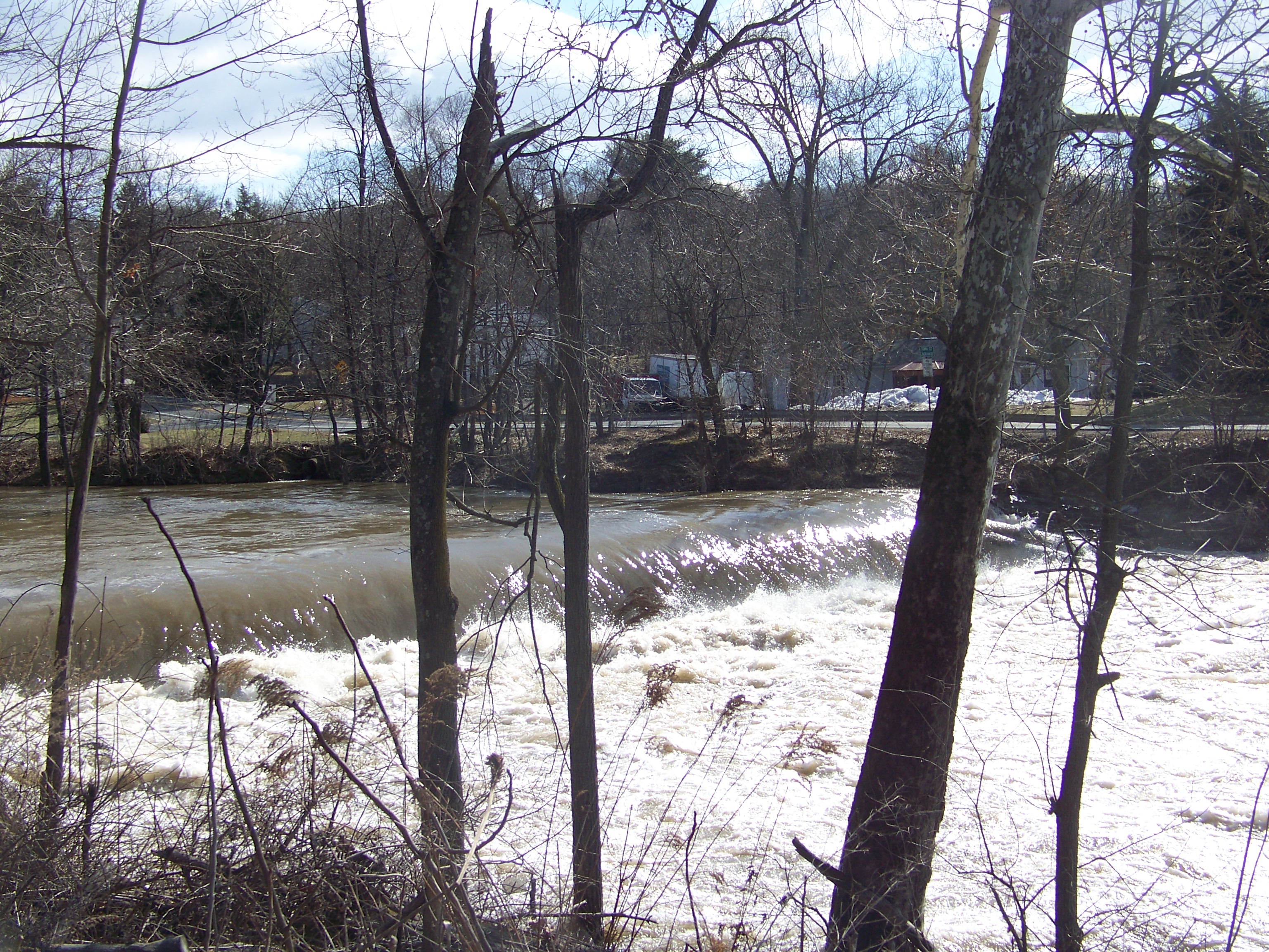
image_caption = Wappinger Creek at Red Oaks Mill
country =USA
state =New York
region = Dutchess
region_type = County
district =
municipality =Wappingers, New York ,Poughkeepsie, New York
source = Thompson Pond
source_location = Pine Plains | source_region = | source_country =
source_elevation_imperial =
source_lat_d = | source_lat_m = | source_lat_s = | source_lat_ = 41.5823158
source_long_d = | source_long_m = | source_long_s = | source_long_ = -73.6712383
mouth =Hudson River
mouth_location =New Hamburg, New York | mouth_region = DutchessCounty| mouth_country = USA
mouth_elevation_imperial =
mouth_lat_d = | mouth_lat_m = | mouth_lat_s = | mouth_lat_ = 41.5823158
mouth_long_d = | mouth_long_m = | mouth_long_s = | mouth_long_ = -73.9479157
length_imperial = 36| length_orientation = North–south
width_imperial = | width_orientation =
depth_imperial =
volume_imperial =
warershed_imperial =
discharge_imperial =
discharge_max_imperial =
discharge_min_imperial =
free = | free_type =
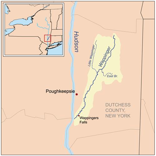
map_caption = Wappinger Creek Watershed
map_background =
map_locator =
map_locator_x =
map_locator_y =
website =
footnotes = cite web | work =Geographic Names Information System | publisher =United States Geological Survey | date =January 23 ,1980 |url=http://geonames.usgs.gov/pls/gnispublic/f?p=136:3:366818524881346406::NO::P3_FID:968772| title = Wappinger Creek | accessdate =2008-07-20]Wappinger Creek is a roughly convert|36|mi|km|abbr=on [cite journal|author=Jason Martin, et al|title=Wandering the Wappinger Creek|year=2008] long creek which runs from Thompson Pond in
Dutchess County, New York .Overview
The creek flows in a north–south direction on the eastern side of the
Hudson River . The creek's source is Thompson Pond near Pine Plains, and it heads southeastward towards its mouth in the Hudson River near New Hamburg. Along the way, it goes through fluctuations in width and follows an erratic path; in Wappingers Falls, it forms Wappinger Lake, a man-made reservoir.Cite web|author=|title=Wappinger Lake Fishing in Dutchess County, New York|publisher=Fishingworks.com|accessdate=2008-05-27|url=http://www.fishingworks.com/lakes/new-york/dutchess/wappingers-falls/wappinger-lake/] The initial convert|.25|mi|km|abbr=on|lk=on of the creek runs through rocky, steep, wooded terrain. However as it approaches the Hudson it enters the river's tidal range, and has sandbars, mudflats and marshes. The creek is also home to numerous species, and is an important spawning area foranadromous fish, which thrive in the creek between April and June.Largemouth bass ,bluegill ,pumpkinseed ,red-breasted sunfish , andbrown bullhead , however, are resident species.Cite web|author=NYSwaterfronts.com|title=COASTAL FISH & WILDLIFE HABITAT RATING FORM|year=1987|publisher=|accessdate=2008-05-27|url=http://www.nyswaterfronts.com/downloads/pdfs/sig_hab/hudsonriver/Wappinger_Creek.pdf] Also, the creek is annually stocked with various species of trout for the purpose of recreational fishing. [Cite web|author=|title=Spring 2008 Trout Stocking for Dutchess County|year=2008|publisher=New York State DEC|accessdate=2008-05-27|url=http://www.dec.ny.gov/outdoor/23326.html]Tributaries
Wappinger Creek has four distinct tributaries; the longest of which is Little Wappinger Creek which enters the creek from the east bank.
The tributaries are listed below from the source to the mouth, with Hunns Lake Creek being the northern most and Little Wappinger Creek being the southernmost.
References
See also
*
List of rivers in New York External links
* [http://newweb.erh.noaa.gov/ahps2/hydrograph.php?wfo=aly&gage=wapn6&view=1,1,1,1,1,1 Wappingers Creek water level]
Wikimedia Foundation. 2010.