- New York State Route 9D
-
NYS Route 9D
Route information Auxiliary route of US 9 Maintained by NYSDOT and the city of Beacon Length: 25.21 mi[2] (40.57 km) Existed: 1930[1] – present Major junctions South end: 
 US 6 / US 202 in Cortlandt
 I-84 / NY 52 near Beacon
North end: 
 US 9 / CR 77 in Poughkeepsie town
Location Counties: Westchester, Putnam, Dutchess Highway system Numbered highways in New York
Interstate • U.S. • N.Y. (former) • Reference • County←  NY 9B
NY 9BUS 9E  →
→New York State Route 9D (NY 9D), also known as the Bear Mountain – Beacon Highway, is a north–south state highway that runs along the eastern shore of the Hudson River in New York in the United States. It starts at the eastern end of the Bear Mountain Bridge at U.S. Route 6 (US 6) and US 202 in Westchester County, and ends at the intersection of Vassar Road (County Route 77) and US 9 north of the village of Wappingers Falls in Dutchess County. While US 9 follows a more inland routing between the bridge and Wappingers Falls, NY 9D runs along the river to serve the village of Cold Spring and the city of Beacon. The route originally began in Beacon when it was assigned in 1930; it was extended south to the Bear Mountain Bridge by the following year.
Contents
Route description
Westchester and Putnam Counties
Like its parent road, U.S. Route 9 (US 9), NY 9D runs north–south parallel to the Hudson River for its entire length. The route begins near the riverbank at the Bear Mountain Bridge, where it meets US 6 and US 202. A mere quarter-mile to the north, NY 9D passes into Putnam County.
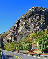 Breakneck Ridge and the tunnel
After crossing the Appalachian Trail, NY 9D passes a few historical areas, such as the house Benedict Arnold was holed up in prior to his treason, the point of land where he caught the ship downriver to New York City, and the eastern end of the chain that was strung across the Hudson River during the American Revolution to prevent ships from coming upriver north of West Point. Continuing north, NY 9D enters Garrison. Near the town center, at The Birches and the Garrison Grist Mill Historic District, NY 9D meets the western terminus of NY 403, an intra-county route leading to US 9 to the east.
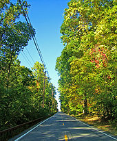
5 miles (8 km) to the north, NY 9D passes the historic Boscobel mansion and enters Cold Spring and becomes Chestnut Street. In the center of the village, NY 9D intersects Main Street, which carries NY 301 east of this point. On the opposite side of the intersection, NY 9D becomes Morris Avenue. A mile to the north of downtown Cold Spring, NY 9D merges with Fair Street, which runs along the Hudson in Cold Spring, and becomes the main riverside highway. The route, mere yards from the river, parallels the Metro-North Railroad for the next 2 miles (3 km) through Hudson Highlands State Park. This section of the route is locally known as the River Road, for its close proximity to the river, and "The Flats", for its relatively consistent elevation.
At the Putnam–Dutchess county line, NY 9D passes through the Breakneck Ridge tunnel, emerging in Dutchess County on the opposite side. Entering Beacon, NY along the river, parallelimg Beacon's Main Street.
Dutchess County
 NY 9D approaching Beacon
Heading away from Breakneck Mountain, NY 9D continues on a northerly path, heading away from the Metro-North line and the Hudson River, to the southern edge of the City of Beacon. At this point the route transitions from rural mountainous scenery to an urban setting when it becomes Wolcott Avenue. Upon reaching the city, however, NY 9D turns 90 degrees to the northwest and becomes the main north–south street through the city. Shortly after completing the turn, NY 9D crosses Fishkill Creek.
0.75 miles (1.21 km) northwest of the creek, NY 9D makes another 90 degree turn, this time to the northeast, giving NY 9D a "S"-shape as it travels through Beacon. To the north of the turn, NY 9D intersects Main Street, carrying NY 52 Business, and becomes North Avenue. NY 52 Business turns north onto NY 9D here, forming a concurrency along NY 9D north to an interchange with Interstate 84, concurrent with NY 52, on the northern edge of the city. NY 52 Business terminates at the interchange with I-84 and NY 52, while NY 9D continues north along the banks of the Hudson.
 Downtown Wappingers Falls
1 mile (1.6 km) north of Beacon, NY 9D runs by Dutchess Stadium, the home of the Hudson Valley Renegades, a Class A Minor League Baseball team. Further north, it passes west of the hamlets of Chelsea and New Hamburg, both of which lie on the banks of the Hudson.
Ultimately, NY 9D enters the village of Wappingers Falls from the south as South Avenue and comes to a T-intersection with East Main Street in front of Mesier Park. NY 9D turns left and follows East Main across Wappinger Creek, becoming West Main Street as it crosses over the water body and makes a sharp bend to the right (north). The route runs alongside Wappinger Lake for a short distance before terminating at US 9 north of the village, in the shadow of the South Hills Mall and the Poughkeepsie Galleria to the near west. County Route 77 (Vassar Road) continues on the other side of Route 9 as an extension of this road.
History
NY 9D was assigned as part of the 1930 renumbering of state highways in New York to the portion of its modern alignment north of Beacon. At the same time, the segment of modern NY 9D from the Bear Mountain Bridge north to Cold Spring became part of NY 9C, which continued south through Peekskill[1] to Croton-on-Hudson.[3] NY 9D was extended south to the Bear Mountain Bridge by the following year, replacing NY 9C from Cold Spring to the bridge.[4]
Major intersections
County Location Mile[2] Destinations Notes Westchester Cortlandt 0.00 US 6 / US 202Bear Mountain Bridge Putnam Philipstown 4.54  NY 403
Hamlet of Garrison; western terminus of NY 403 7.92  CR 16
CR 16Just outside Cold Spring village line Cold Spring 8.64  NY 301
Western terminus of NY 301 Dutchess Beacon 16.35 
NY 52 Bus. east (Main Street)Southern terminus of NY 9D / NY 52 Bus. overlap Fishkill 17.13 
I-84 / NY 52 / NY 52 Bus.Just outside Beacon city line; exit 11 (I-84/NY 52); northern terminus of NY 52 Business and NY 9D / NY 52 Bus. overlap Wappinger 22.38  CR 28
CR 28Hamlet of Hughsonville Town of Poughkeepsie 25.21 US 9 / CR 771.000 mi = 1.609 km; 1.000 km = 0.621 mi References
- ^ a b Standard Oil Company of New York (1930). Road Map of New York (Map). Cartography by General Drafting.
- ^ a b "2008 Traffic Volume Report for New York State" (PDF). New York State Department of Transportation. June 16, 2009. pp. 27–28. https://www.nysdot.gov/divisions/engineering/technical-services/hds-respository/NYSDOT%20TVR%202008%20by%20Route.pdf. Retrieved January 31, 2010.
- ^ Texas Oil Company (1932). Texaco Road Map – New York (Map). Cartography by Rand McNally and Company.
- ^ Kendall Refining Company (1931). New York (Map). Cartography by H.M. Gousha Company.
External links
Categories:- State highways in New York
- U.S. Route 9
- Hudson River
- Transportation in Westchester County, New York
- Transportation in Putnam County, New York
- Transportation in Dutchess County, New York


Wikimedia Foundation. 2010.