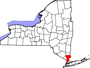
- Cortlandt, New York
-
This article is about the town in Westchester County, New York. For the city in Cortland County in upstate New York, see Cortland, New York.
Cortlandt, New York — Town — Location within the state of New York Coordinates: 41°15′41″N 73°54′9″W / 41.26139°N 73.9025°WCoordinates: 41°15′41″N 73°54′9″W / 41.26139°N 73.9025°W Country United States State New York County Westchester Area – Total 50.2 sq mi (129.9 km2) – Land 39.7 sq mi (102.7 km2) – Water 10.5 sq mi (27.2 km2) Elevation 318 ft (97 m) Population (2010) – Total 41,592 – Density 829.3/sq mi (320.2/km2) Time zone Eastern (EST) (UTC-5) – Summer (DST) EDT (UTC-4) FIPS code 36-18410 GNIS feature ID 0978871 Website http://townofcortlandt.com Cortlandt is a town in Westchester County, New York, United States. The population was 41,592 at the 2010 census.[1]
The Town of Cortlandt is in the northwest part of the county. The town includes the villages of Buchanan and Croton-on-Hudson.
Commuter service to New York City is available via the Cortlandt train station and the Croton-Harmon train station, served by Metro-North Railroad.
U.S. Route 9 passes through the town along the Hudson River side.
Contents
Geography
The town is bordered on the west by the Hudson River and the city of Peekskill. It is bordered to the north by the towns of Philipstown and Putnam Valley in Putnam County, to the east by Yorktown and on the south by the towns of New Castle and Ossining.
According to the United States Census Bureau, the town has a total area of 50.2 square miles (130 km2), of which 39.7 square miles (103 km2) is land and 10.5 square miles (27 km2) is water.
Demographics
As of the census[2] of 2000, there were 38,467 people, 13,517 households, and 10,137 families residing in the town. The population density was 969.7 people per square mile (374.4/km²). There were 14,065 housing units at an average density of 354.5 per square mile (136.9/km²). The racial makeup of the town was 88.60% White, 4.59% African American, 0.21% Native American, 2.57% Asian, 0.01% Pacific Islander, 2.35% from other races, and 1.68% from two or more races. Hispanic or Latino of any race were 7.19% of the population.
There were 13,517 households out of which 39.3% had children under the age of 18 living with them, 64.3% were married couples living together, 7.9% had a female householder with no husband present, and 25.0% were non-families. 21.3% of all households were made up of individuals and 8.8% had someone living alone who was 65 years of age or older. The average household size was 2.75 and the average family size was 3.22.
In the town the population was spread out with 26.5% under the age of 18, 5.3% from 18 to 24, 30.1% from 25 to 44, 25.3% from 45 to 64, and 12.8% who were 65 years of age or older. The median age was 39 years. For every 100 females there were 95.8 males. For every 100 females age 18 and over, there were 92.7 males.
The median income for a household in the town was $75,442, and the median income for a family was $89,053. Males had a median income of $59,949 versus $41,115 for females. The per capita income for the town was $33,432. About 2.9% of families and 4.5% of the population were below the poverty line, including 4.1% of those under age 18 and 5.1% of those age 65 or over.
Communities and locations in Cortlandt
- Buchanan – the Village of Buchanan
- Chimney Corners – a hamlet north of Croton-on-Hudson
- Cortlandt Manor – an area in the town of Cortlandt
- Croton-on-Hudson – the Village of Croton-on-Hudson
- Crugers – a hamlet of Cortlandt. Includes the Cortlandt train station.
- Furnace Woods
- Mohegan Lake – a hamlet partially in the town of Cortlandt
- Montrose – a hamlet of Cortlandt
- Mount Airy – a neighborhood
- Oscawana – includes Oscawana Island
- Pleasantside
- Roe Park
- Teatown – a hamlet partially in the town of Cortlandt
- Toddville
- Valeria
- Van Cortlandtville – The John Jones Homestead, Old St. Peter's Church, and Van Cortlandtville School are listed on the National Register of Historic Places.[3]
- Verplanck – a hamlet of Cortlandt
- Woodybrook
References
- ^ "Profile of General Population and Housing Characteristics: 2010 Demographic Profile Data (DP-1): Cortlandt town, Westchester County, New York". U.S. Census Bureau, American Factfinder. http://factfinder2.census.gov. Retrieved November 15, 2011.
- ^ "American FactFinder". United States Census Bureau. http://factfinder.census.gov. Retrieved 2008-01-31.
- ^ "National Register Information System". National Register of Historic Places. National Park Service. 2009-03-13. http://nrhp.focus.nps.gov/natreg/docs/All_Data.html.
External links
Categories:- Towns in New York
- Populated places in Westchester County, New York
Wikimedia Foundation. 2010.


